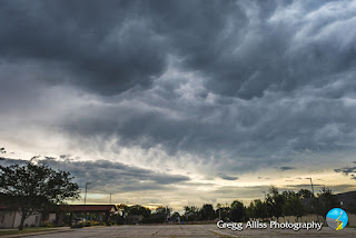
Cedar Rapids Evades Severe Weather Again
Saturday, August 20, 2022
11:22 am CDT, Friday, August 19, 2022. Storm Prediction Center (SPC) Slight Risk is modified from previous coverage of most of the eastern half of Iowa.
3:05 pm. Severe Thunderstorm Watch 521 is issued, valid until 8:00 pm for central, southern and eastern Iowa. Two severe-warned storm cells are under way and moving east, one east of Fort Dodge, and the other over the Des Moines metropolitan area.
5:06 pm. Now set up for spotting operations at Noelridge Christian Church in Cedar Rapids, Iowa. The southern cell has more or less merged with the northern cell and are both tracking to the northeast, taking the system north and away from the Cedar Rapids area. The panoramic image above looks west.
5:24 pm. Closeup of the left edge (south) of the storm, looking due west.
Radarscope image corresponding to 5:36 pm. The blue target icon is my location, with the severe warned area shown in the accompanying photographs located to my northwest, about 25 miles distant near Urbana, Iowa in Benton County. Note the Spotter Network tornado report (upper left) from a spotter near Oelwein, Iowa.
5:37 pm. Looking east with roiling mammatus clouds moving overhead.
5:38 pm. Funnel-like scud cloud looking west.
5:43 pm. Looking northwest at severe-warned storm cell, now more compact in size.
5:44 pm. Zoomed-in version of image above it. Nikon D7200 DSLR camera.


0 comments:
Post a Comment