My storm chase of a severe-warned cell on the afternoon/evening of May 7, 2023 in east-central Iowa was one of scrambling to get into position and scrambling to get out of its way. I would spend no more than five minutes at any location, and would frequently jump out of my vehicle in front of the approaching storm, snap a few pictures, jump back in and flee to a better position. Because of the lack of time, my camera tripod never left its case! My window of escape before wind or hail arrived was many times measured in mere minutes, and thankfully I was successful in this endeavor the entire chase. No hail stone touched my vehicle. The images above show the Storm Prediction Center's (SPC) categorical, tornado, hail and wind outlooks at 11:30 am CDT.
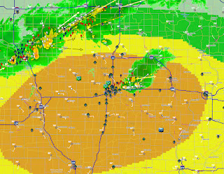
Weathertap radar for 11:37 am, showing the storm cell beginning to fire up east of Des Moines. The orange area is the SPC Enhanced Risk, the yellow area a Slight Risk.
3:11 pm. Now on the road westbound on Shellsburg Road (E36), just north of Hollenbeck Road in Palo, Iowa. Distant storm clouds are gathering on the horizon. I had made the decision to travel west in a more northerly position, thinking the storm cell forming to the east would make a more northeasterly track. This proved to be incorrect. I now had to reposition south.
Radarscope frame capture for 3:22 pm. My targeted severe-warned storm cell was still a good distance away (southwest of Marshalltown) but I still needed to get south to position myself southeast of it when it arrived. Pay attention here to the two small cells east of Marshalltown and south of Traer...
3:30 pm. The two small cells have now intensified and are beginning to merge--and much closer to me. Another small cell is also forming nearby. My window to get south was now closing.
3:34 pm. A quick stop on 2nd Avenue next to Vinton-Shellsburg High School in Vinton, Iowa. Looking southwest at growing storm cell.
3:42 pm. Westbound on 64th Street (E30) just east of US Highway 218 in Benton County. The road configuration here required me to briefly travel west (toward the approaching storm) before I could turn south again (left, in the distance above).
3:45 pm. Southbound on US Highway 218, about 3.5 miles northeast of Van Horne, Iowa. Storm is about 15 miles to my southwest.
3:47 pm. Storm to my immediate west is intensifying, and is now sporting a hail core. My need to get south was getting more urgent!
3:52 pm. Now merging onto westbound US Highway 30 from southbound US Highway 218. My situation was again in the direct path of the storm.
3:55 pm. Westbound on US Highway 30 and looking impatiently for a south option. It was coming up soon (background left)-- County Road V66 detour (Highway 82) in Benton County.
3:57 pm. Brief stop. Looking west at picturesque approaching storm from 74th Street, a quarter-mile west of County Road V66 (82), and 2.6 miles north of Blairstown in Benton County.
3:57 pm. Panoramic view.
4:08 pm. Very low, ground hugging inflow cloud, looking west while southbound on County Road V66 near Blairstown, Iowa.
4:13 pm. Another brief stop. Looking west at approaching severe-warned cell alongside V66, about 1.5 miles north of the town of Marengo in Iowa County.
4:15 pm. Finally getting south of the severe-warned cell just to my northwest.
4:16 pm. Brief stop on V66 at a railroad yard in the town of Marengo. Storm (right) is advancing from the northwest.
4:20 pm. Dramatic shelf cloud from the severe-warned cell approaching from the northwest, seen from V66 (M Avenue) 2.3 miles south of Marengo. I had jumped out of my vehicle, snapped a few shots, and jumped back in to continue heading south.
4:20. Panoramic version. It was approaching fast!
4:24 pm. Panorama looking northwest from 190th Street (left) at V66 (M Avenue, right). I had been anxiously looking for a spot to turn off on the right side of V66 to catch this beautiful storm, and found it at this location. I spent the longest amount of time out of the vehicle during the chase here (maybe 3-4 minutes) before resuming my south escape.
4:24 pm. Looking northwest with my vehicle in the foreground. 190th Street is at left.
4:24 pm. Similar view.
4:29 pm. Now fleeing eastbound on Interstate 80 near the Williamsburg Kinze Manufacturing plant in Iowa County. The menacing storm is to my north. Frequent bolts of positive CG lightning were occurring at this time, indicating an intensifying storm.
4:30 pm. Emergency Alert on my cell phone, warning of a severe thunderstorm warning with baseball size hail.
4:32 pm. Storm appearing to roll over the McDonald's truck stop in Williamsburg. My objective was to outrun the storm to the east, then race northbound on Interstate 380 in time not to be impacted by it.
Corresponding radar image to the photograph above it. My location is the blue Spotter Network target.
4:37 pm. Looking back at the awesome storm structure while racing east on Interstate 80, between Williamsburg and Amana.
4:55 pm. Looking west while northbound on Interstate 380 near North Liberty, Iowa in Johnson County. It was a race now for me to get ahead of it to the north. At this time I began formulating a plan to either stop and spot at the BP convenience store at the Shueyville exit coming up, or stop at the exit and take some quick shots before departing again.
5:00 pm. At the Shueyville exit (Exit 10). Looking back south from the I-380 off ramp. The truck with the camper in the background was parked alongside the road with the intent to ride out the storm.
5:00 pm. Panorama of the incoming storm from the exit.
5:00 pm. Similar shot with my vehicle in the foreground. It was right now that I had to make a decision: pull into the convenience store and be impacted by the storm or get out right now and resume north. I chose the latter, but not without problems. There was a convergence of traffic here, some indecisive and some in a panic snarling up the road. I was finally able to get back on to I-380, and probably with only minutes to spare. Wind and rain impacted me, but I missed the hail.
Dual-pane radar image for 5:03 pm, showing reflectivity (top), and velocity (bottom).
Weathertap radar image for 5:58 pm. I was safely home by this time, but a tornado warning (right) showed up in Muscatine County. The black target is Cedar Rapids.
But the day was not over for me yet--- a "cherry on top of the dessert" was coming. Beautiful mammatus formations revealed themselves to all in Cedar Rapids. The sunset-lit mammatus resembled globules from a lava lamp. The image above in Bowman Woods Park was captured at 6:47 pm.
6:48 pm. Mammatus over Bowman Woods Elementary School. Mammatus are rapidly descending clouds from very moist air and are usually formed in association with turbulence in cumulonimbus clouds. Though they are associated with severe weather, mammatus clouds themselves are not dangerous.
6:55 pm. Growing more distinct.
7:01 pm. Though maybe not the best mammatus I've ever seen, I would definitely rank this event in my top five. Nikon D7200 DSLR camera.
Read more...


