Storms Fast Opening Act, Beautiful Finale

Tuesday, July 28, 2020


A line of storms began forming quickly just east of Cedar Rapids, Iowa around 4:00 pm CDT on Sunday, July 26, 2020, began intensifying, then moved east. The image above, looking southeast at 5:03 pm from Bowman Woods Park in Cedar Rapids, shows a very strong area of that line about five minutes before it went severe warned. The area was located about 20 miles to the ESE, near the town of Mechanicsville in Cedar County.


5:04 pm. This was a multi-cellular storm, but these two cells merged (above) as it progressed.


Radarscope capture from 5:05 pm, showing the line of storms and the severe-warned polygon.


5:17 pm. Panorama of the storm after it had gone severe warned. The most intense area of the line was located about 22 miles distant, just west of the town of Stanwood in Cedar County.


5:22 pm. Interesting cloud feature resembling a horizontal funnel, looking east from my backyard. This particular storm system would move on and into far Eastern Iowa after 7:00 pm.


A new area of storms had gotten going to the south and east of Cedar Rapids around 6:00 pm, and these too intensified. With daylight fading, the sky to the east turned brilliant with reflective pinks, yellows and oranges. This image looks east from my backyard at 8:33 pm. The illuminated clouds in the background were located in Jones County, about 30 miles distant.


8:33 pm. Vertical capture.


8:34 pm. Panoramic view from backyard.


Radar capture corresponding to 8:35 pm. My location is illustrated by the target icon at left, the area of clouds exhibiting the brilliant luminosity are shown at right.


8:38 pm. Another panoramic capture. Within about ten minutes this scene faded into darkness. Nikon D7200 DSLR camera.


Read more...

NEOWISE Composite Pic

Saturday, July 25, 2020


This is a composite image of the Comet NEOWISE and the water tower at the Linn County Engineer facility at Highway 13 and County Home Road, about 2.5 miles north of Marion, Iowa. Both the comet and water tower were photographed from this same location, but at slightly different times and positions in the sky on Wednesday, July 22, 2020. The water tower was captured at 9:41 pm CDT, and is a 13 second exposure at f/4.5, ISO 160 and 34mm focal length. The comet was captured at 10:22 pm and is a 15 second exposure at f/4.5, ISO 2000 and 26mm focal length. The background is a stack of four images to reduce noise. The water tower was once part of the Linn County Home, which was operated from 1892-1977. Nikon D7200 DSLR camera.

Read more...

NEOWISE, Jupiter, Saturn, Moon & Milky Way

Thursday, July 23, 2020


The Comet NEOWISE (C/2020 F3) made its closest approach to Earth on July 22-23, 2020, and unfortunately from here on it's all "down hill"--the comet is heading back out to space, is beginning to dim, and will fade out completely sometime next month. Because of this, I consider the recent days of clear skies precious. I did not plan it, but in the image above the International Space Station (ISS) glided by just above NEOWISE at 9:53 pm CDT on Sunday, July 19, and I was able to capture it. Location was Lowe Park in Marion, Iowa. The faint star just above the comet's coma is the 7.56 magnitude HIP46351 in the constellation Ursa Major. Three combined images, each a 15 second exposure at f/4, ISO 500 and 70mm focal length.


10:05 pm. This was a test shot from Lowe Park, with a very vibrant band of clouds stretching over the lights of the area. 10 second exposure at f/5.6, ISO 320, 80mm focal length.


10:12 pm. Closeup of the comet. 15 second exposure at f/4, ISO 1000, 70mm focal length.


Next evening, July 20. Skies were beautifully clear upon my arrival at my desired photography location--in rural Shueyville, Iowa, but within a half-hour of the capture of this image at 9:55 pm, the sky had become completely clouded over, and the show was over for the night! Image looks northwest. 10 second exposure at f/2.8, ISO 400, 16mm focal length.


The planets Saturn and Jupiter were in conjunction and at their brightest on the evening of Tuesday, July 21, and their capture was my prime objective for the night. This picture looks southeast from Bowman Woods Park in Cedar Rapids, Iowa at 10:13 pm. Saturn (left) reflected at magnitude 0.10, while Jupiter was much brighter at magnitude -2.74. Two of Jupiter's moons (Callisto and Ganymede) can be seen close and left of the planet. 2 second exposure at f/4, ISO 1250, 70mm focal length.


300mm focal length closeup images of the two planets, with their largest moons included. Lens not powerful enough the resolve the rings of Saturn.


Meanwhile, a bank of clouds to the west had finally lifted, giving me an opportunity to capture NEOWISE. Unfortunately, high humidity was causing heavy condensation on my camera's lens, and this smudgy image taken at 10:50 pm was one of the best. 15 second exposure at f/5, ISO 1250, 70mm focal length.


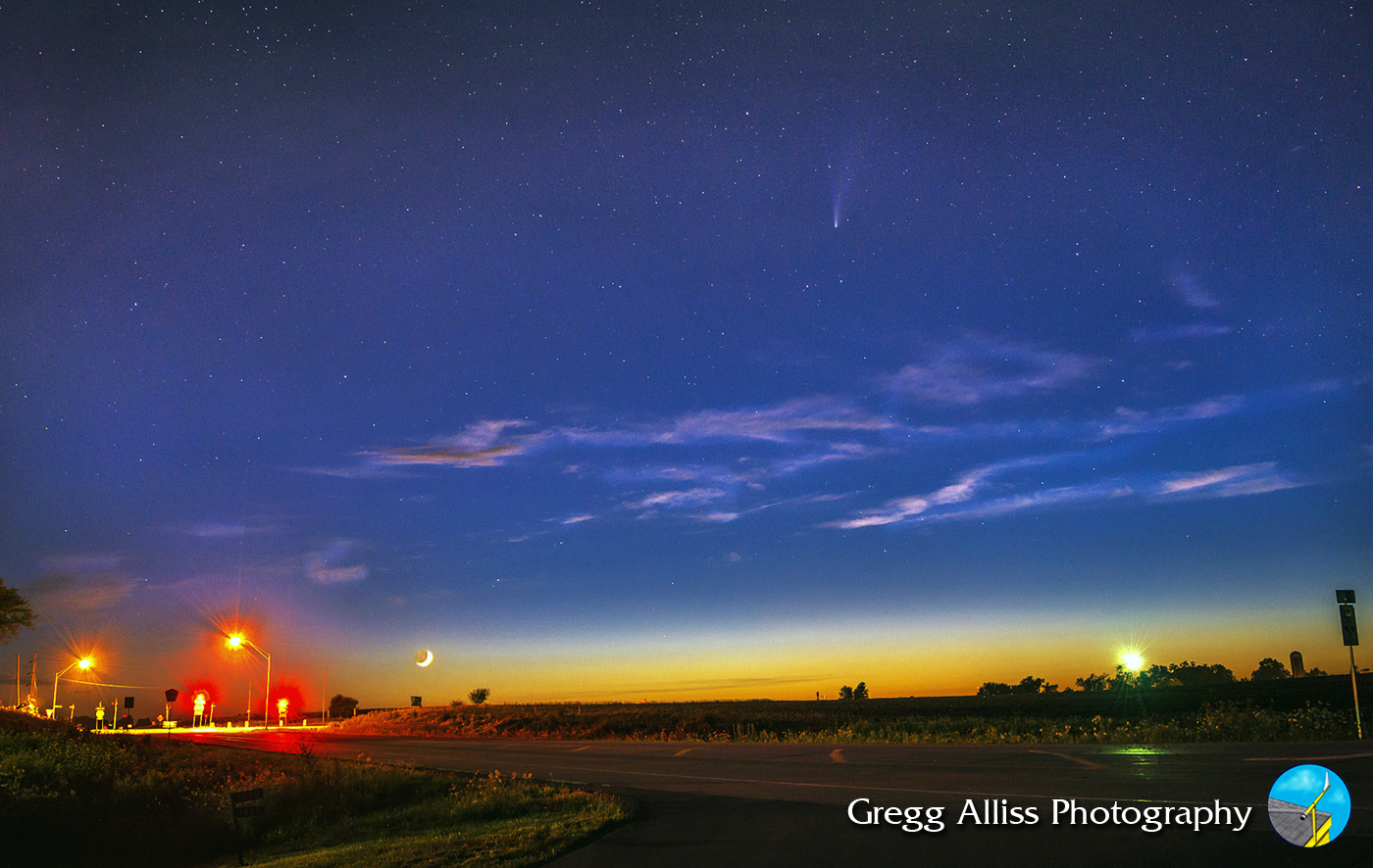
Wednesday, July 22, 2020. The evening sky started clear and stayed that way! NEOWISE made its closest approach to Earth during this night, with the added bonus of a thin crescent moon included, if one was fast enough to capture them both before the moon set. This is another test shot, more about the moon. The image looks west at 9:37 pm from County Home Road (E34), about .1-mile east of Highway 13, and about 2.5 miles north of Marion, Iowa. The intersection of both roads is illuminated in the background. 2 second exposure at f/5.6, ISO 200, 52mm focal length.


9:56 pm. Same location with Comet NEOWISE included. Moon is setting and low on the horizon at left. 10 second exposure at f/3.5, ISO 500, 18mm focal length.


9:58 pm. 10 second exposure at f/3.5, ISO 500, 18mm focal length.


10:19 pm. Closeup of the comet among some thin passing clouds. 15 second exposure at f/4.8, ISO 2000, 38mm focal length. A shout-out to the couple who unexpectedly joined me at this location last night to view NEOWISE. Good company and conversation!


10:26 pm. 13 second exposure at f/4, ISO 2500, 26mm focal length.


10:31 pm. Getting close to my time to head back home. The sky, though, had another cool feature in store--the Milky Way. Though I was somewhat surprised by its clarity, the location is far enough north and away from the light polluted skies of the Cedar Rapids/Marion area. This panorama image is a merge of four separate photographs, all 15 second exposures at f/3.5, ISO 2500, 18mm focal length. The left part of the image is the northeast sky, and stretches to the southeast at right.


10:33 pm. Bright planets Saturn and Jupiter (center) were still there too, in this image looking SSE. Part of the Milky Way stretches skyward at right. 10 second exposure at f/3.5, ISO 2500, 18mm focal length. Nikon D7200 DSLR camera.

Read more...

Patriotic Balloons

Monday, July 20, 2020


Three hot air balloons drifted over the cities of Marion and Cedar Rapids, Iowa on the evening of July 4, 2020--Independence Day, each with an American flag draped from their gondolas. This image looks northwest from Bowman Woods Park in Cedar Rapids, Iowa at 8:21 pm CDT. The balloons were moving away from the camera.


A single balloon is silhouetted by the setting sun in this image captured at 8:23 pm, looking west. Nikon D7200 DSLR camera.

Read more...

Good Evening, NEOWISE

Saturday, July 18, 2020


The Comet NEOWISE (C/2020 F3) began transitioning from a predawn observing event to an evening one starting about Monday, July 13, 2020. My first attempt at photographic capture of the evening comet on July 13 was not a memorable one. I was never able to make it out with my eyes, couldn't find it with binoculars, and had conflict with drifting clouds. Once again though, long  exposures from my camera pulled it out--albeit dimly. Above, the camera looks northwest at 9:47 pm CDT from near East Robins Road and Alburnett Road in Marion, Iowa. 10 second exposure at f/4.5, ISO 160 and 34mm focal length.


Two evenings later and again only marginally successful results. Though the evening of Wednesday, July 15 began with a promising weather outlook, clouds began moving in just as the comet became visible in darkening skies. This image was one of the few I captured before clouds blocked the view. The comet was again dim because of the early evening hour. This is a northwest look from a pond in rural Shueyville, Iowa at 9:30 pm. 8 second exposure at f/4, ISO 160 and 35mm focal length.


Thursday, July 16, 2020. Clear skies and lower humidity--ideal comet viewing conditions. This view looks west from Bowman Woods Park in Cedar Rapids, Iowa at 10:19 pm. On this night I could see  the comet with the naked eye, even with the light pollution in the background. 15 second exposure at f/5.3, ISO 400 and 48mm focal length.


10:32 pm. Near the top of Bowman Woods Park sledding hill, looking northwest over Bowman Woods Elementary School. 15 second exposure at f/5, ISO 500 and 25mm focal length.


10:44 pm. Closeup of Comet NEOWISE. 15 second exposure at f/5, ISO 500 and 46mm focal length.


10:45 pm. Similar view. 10 second exposure at f/5, ISO 800 and 46mm focal length.


10:48 pm. Another closeup. 15 second exposure at f/5.6, ISO 800 and 55mm focal length.


Following night, Friday, July 17, 2020. Mostly clear but oppressively humid and my camera lens fogged frequently. Distant clouds were seen along the northern horizon, but were moving away. My location on this night was from the grounds of Echo Hill Presbyterian Church north of Marion, Iowa. This image was captured at 9:58 pm and is a 15 second exposure at f/5, ISO 500, 26mm focal length.


10:18 pm. Same location. Foreground weeds were "light painted" by use of a flashlight. 15 second exposure at f/4.2, ISO 500 and 28mm focal length.


10:30 pm. My wife activated my camera's two second shutter delay and light painted the foreground in this image--including yours truly! 8 second exposure at f/4.2, ISO 800 and 28mm focal length.


10:36 pm. Comet NEOWISE in the northwest sky. 15 second exposure at f/4.2, ISO 800 and 28mm focal length.


10:44 pm. One last shot before calling it a night. 15 second exposure at f/4.2, ISO 800 and 28mm focal length. Nikon D7200 DSLR camera.

Read more...

July 9 Storm

Friday, July 17, 2020


Severe Thunderstorm Watch 348 was issued by The Storm Prediction Center (SPC) for the eastern half of Iowa on Thursday morning, July 9, 2020.


The Thunderstorm Outlook posted at 11:51 am CDT showed similar prospects, and prospects looked good for an intercept with severe weather advancing east into northeast Iowa by the early afternoon. My son-in-law accompanied me on this intercept, and we headed north on Highway 13.


1:45 pm. Sky to the north growing dark. We are northbound on Highway 38, about 1.8 miles south of Greeley, Iowa in Delaware, County.


1:49 pm. Northbound on Highway 38, about .9-mile north of Greeley in northern Delaware County.


1:49. Nearer to wind farm on Highway 38.


2:26 pm. Stationary on 10 Street, about a tenth of a mile east of C Avenue (Highway 187) at the  Fayette/Buchanan county line. Image looks northwest at approaching storm. Storm was moving right-to-left in image.


2:27 pm. Panorama looking west from spotting position on 10th Street.


2:46 pm. Shelf cloud in distance while southbound on C Avenue (Highway 187), about 2.9 miles north of US Highway 20. Storm was moving right-to-left in image and across our path.


2:47 pm. Similar capture. Nikon D7200 DSLR camera.


2:58 pm. Westbound on US Highway 20. A brief but intense rain squall made driving past this semi rig very difficult--and dangerous! The severe weather was moving on east in the north so we returned home. This image is a GoPro Hero 4 video frame capture.

Read more...

Double Shelved

Thursday, July 16, 2020


The weather on Saturday, July 11, 2020 was rare in that two shelf cloud/gust front events occurred in the same areas of Eastern Iowa on the same day--one in the morning, and one in the evening. I was a little caught off guard by the morning event. My wife and I were invited to a friend's acreage near Robins, Iowa to pick gooseberries on their property, and I was unfortunately unprepared for the coming storm with only with my cell phone with me. In the image above, we are northbound on Council Street about .75-mile south of East Main Street near Robins at 9:11 am CDT, en route to our destination. The most intense area of the severe-warned storm (left) was located about 52 miles distant, near Readlyn, Iowa in Bremer County.


9:14 am. Westbound on West Main Street in Robins at Quass Road and nearing our berry picking destination. Image looks north toward the storm.


10:19 am. Berries mostly picked, and just in time. Above, an incoming and impressively striated shelf cloud approaches from the north. The severe-warned gust front was about 12 miles away. Image captured from Stamy Road and West Main Street in Robins.


Radar frame capture corresponding to 10:20 am, with my location shown by the target icon. Black arrows indicate storm movement. Note the lavender hail core.


10:20 am. Looking northeast at shelf cloud from Stamy Road at West Main Street. This part of the storm was some 11 miles distant, just west of Central City, Iowa.


10:20 am. Panorama capture looking north.


10:21 am. Storm has now closed to about 10 miles distant. Looking north from West Main Street.


10:21 am. Looking northwest. Underside of shelf cloud is very turbulent in appearance.


10:22 am. Panorama of gust front, drawing ever closer at about 8 miles. With the wind picking up and the temperatures falling, I began slowly backpedalling closer to our car. Image looks north from Stamy Road near West Main Street.


10:23 am. Last look at the storm (toward the northeast), before about-facing and hustling to the car. This very impressive looking storm event produced some high winds and rain in the area, but not nearly as much as a second gust front which would occur later in the day. iPhone 6 Plus camera.


10:49 am. Back home. This view of the sky looks east at the trailing end of the departing storm.


Storm Prediction Center (SPC) Convective Outlook, posted at 2:50 pm CDT, with a large area of the state of Iowa in a Slight Risk category for severe weather.


4:00 pm. At my spotting location on Quiver Court, just south of Boyson Road and just west of Alburnett Road in Marion, Iowa, with storms approaching yet again. This image looks northwest at gathering storm clouds. The most intense area of the severe-warned storm cell was located about 40 miles distant, near the town of Traer, Iowa, in Tama County.


4:01 pm. Panorama looking northwest.


4:20 pm. Panorama looking northwest. The most intense area of the storm was located about 32 miles away, near the town of Dysart, Iowa in Tama County.


Radarscope image for 4:38 pm, showing my position at right.


5:44 pm. Edge of incoming severe-warned gust front was about 10 miles to the northwest, near Center Point in Linn County. Storm was now forming a shelf cloud appearance, but not nearly as impressive looking as the earlier morning event.


5:44 pm. A small embedded funnel is seen on the churning leading edge of the shelf cloud at center. The funnel formed and dissipated in mere seconds.


Radar capture corresponding to 5:45 pm. My spotting location is indicated by the target icon, with storm movement shown by the arrows.


5:47 pm. Panorama of the shelf cloud, now just 8 miles distant and near the town of Toddville, Iowa in Linn County.


5:47 pm. Closeup of leading edge of gust front looking north. It was now time to hunker down inside my vehicle and wait out the brunt of the storm. I estimate wind speeds peaked around 70 mph here (it actually rolled my parked car about a quarter-tire turn backward twice). This was a much more powerful wind event than the storm from earlier in the day. Several spotters in the area reported some large trees down. Nikon D7200 DSLR camera.


Radarscope image for 5:51 pm, showing a new (radar indicated) tornado warning east of my location.

Read more...

  © Blogger template On The Road by Ourblogtemplates.com 2009

Back to TOP