Catching Some Rays

Friday, August 26, 2022


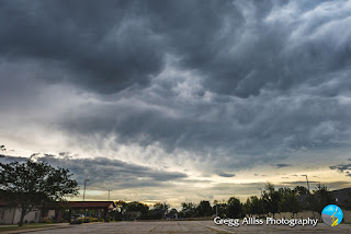
Drifting cumulus clouds covered the setting sun, creating some striking crepuscular rays in Cedar Rapids, Iowa on Sunday evening, August 21, 2022. The views on this post look west over Bowman Woods Park. Time for the image above is 7:09 pm CDT.


7:15 pm.


7:18 pm.


7:19 pm.


7:20 pm. Panoramic capture, showing the formation of an arch. South is to the left. Nikon D7200 DSLR camera.

Read more...

Cedar Rapids Evades Severe Weather Again

Saturday, August 20, 2022


11:22 am CDT, Friday, August 19, 2022. Storm Prediction Center (SPC) Slight Risk is modified from previous coverage of most of the eastern half of Iowa.


3:05 pm. Severe Thunderstorm Watch 521 is issued, valid until 8:00 pm for central, southern and eastern Iowa. Two severe-warned storm cells are under way and moving east, one east of Fort Dodge, and the other over the Des Moines metropolitan area.


5:06 pm. Now set up for spotting operations at Noelridge Christian Church in Cedar Rapids, Iowa. The southern cell has more or less merged with the northern cell and are both tracking to the northeast, taking the system north and away from the Cedar Rapids area. The panoramic image above looks west.


5:24 pm. Closeup of the left edge (south) of the storm, looking due west.


Radarscope image corresponding to 5:36 pm. The blue target icon is my location, with the severe warned area shown in the accompanying photographs located to my northwest, about 25 miles distant near Urbana, Iowa in Benton County. Note the Spotter Network tornado report (upper left) from a spotter near Oelwein, Iowa.


5:37 pm. Looking east with roiling mammatus clouds moving overhead.


5:38 pm. Funnel-like scud cloud looking west.


5:43 pm. Looking northwest at severe-warned storm cell, now more compact in size.


5:44 pm. Zoomed-in version of image above it. Nikon D7200 DSLR camera.


Read more...

Roll Cloud Rollin' on Through...

Saturday, August 13, 2022


This roll cloud was seen from Noelridge Christian Church in Cedar Rapids, Iowa on Sunday morning, August 7, 2022, north of my position and moving toward me to the south. Roll clouds and shelf clouds are closely related, as they are both found near the leading edge of thunderstorms and form when relatively cool air from the storm's downdraft, moves ahead into warm, moist air that's feeding the storm. The difference between the two is that roll clouds are detached from the parent storm. The image above looks due north at 8:03 am CDT.


8:06 am. Looking northwest.


8:07 am. Looking NNW.


8:07 am. Panorama looking north. This storm turned out to be much more foreboding in appearance than its actual strength--some rain and higher wind. Nikon D7200 DSLR camera.

Read more...

2020 Iowa Derecho Nears 2 Year Mark, Additional Photos Posted Here

Saturday, August 6, 2022


 We're coming up on the two year mark of the catastrophic derecho that ravaged Iowa (and especially Cedar Rapids) on August 10, 2020. Wind speeds in Hiawatha, Iowa were estimated at nearly 140 mph--the equivalent of a Category 3 hurricane. This was the costliest land thunderstorm in US history, estimated at around $11 billion in damages. Most definitely a once-in-a-lifetime occurrence. Posted here today are some additional photos of mine that did not make their way to the National Weather Service or TV stations. The image above is a three panel capture of the shelf cloud feature at the leading edge of the derecho as it approached my spotting position on Quiver Court in Marion, Iowa (42° 2'33.74"N,  91°36'48.03"W). Quiver Court is part of the Bowman Meadows housing development, just south of Boyson Road and just west of Alburnett Road. It afforded a clear, 360-degree view of the sky. The images look west, with the top panel captured at 12:33 pm CDT, middle at 12:35 pm, and bottom at 12:36 pm. Note how quickly the storm's appearance changes in such a small amount of time (ground speed was around 60 mph). The bottom panel looks like a giant mouth about to swallow up a cluster of houses (which essentially it did).


12:32 pm. Looking northwest. This image is the last "photo of normalcy" as the storm draws nearer. Darkness from its leading edge can be seen along the horizon at left. One can only look at the houses and trees in this image and imagine the transformation that would take place just a short time later.


12:36 pm. Looking due west. It's serious time--here it comes! With this type of storm (covering hundreds of miles) it was "no where to run, no where to hide." That reality made it dangerous and unnecessary to "chase." It was better to stay as close to home as possible. This location was .8-mile from home.


12:37 pm. Looking southwest. Leading edge almost upon me in this ominous view. Amateur radio was already alive with reports of "fallen mature trees and power outages" a few miles to my west.


12:44 pm. Looking southeast. Very small at left center is some unfortunate person's battered blue swimming pool rolling along vertical in the winds. Wind was from the right-to-left in this image. Note the bending of the tops of the trees in the distant background.


12:49 pm. Looking southwest. Hard-driving rain in the high wind created a white out-like appearance along the ground. Power had been extinguished here about two minutes earlier, after I had witnessed three separate power flashes in the distance toward the west.


1:05 pm. Looking northeast through the front passenger side window. For this shot I lowered the window for a better capture of the background. Open for less than a minute, and even though the wind was impacting the opposite side of the car, everything on the seat became soaked from rain borne by winds exceeding 100 mph. If you look real close at the sideview mirror at lower left, you can see the reflection of a pickup truck whose driver had tucked in behind me, using me as a wind break on the cul-de-sac.


1:07 pm. This is a video frame capture from my mounted Go Pro Hero 4 Silver camera. Image looks northwest, situated directly into the wind. I can remember saying a few prayers and feeling like the experience was similar to that of moving through an automated car wash--the car was rocking and water and suds were blasting my front windshield. You don't however, have 100 mph projectiles coming at you in a car wash! A small piece of debris did hit the metal strip between the windshield and my driver's side window, making me jump out of my seat!


1:36 pm. Traveling west on tree-strewn Boyson Road, near Newcastle Road in an attempt to return home. Dazed motorists slowly weave through the destruction.


1:42 pm. I was denied entry onto my street because of large fallen trees blocking the way, so I continued on, seeking an alternate route home. Because my spotting location had been in a open and newer area, there weren't many large trees down there. But as I continued west on Boyson Road it became apparent widespread destruction had taken place in the older neighborhoods. The image above, east of C Avenue on Boyson Road, is an example of that. 


1:45 pm. Continuing on in search of an outlet to my street. This image looks south from C Avenue NE in Cedar Rapids, just south of Boyson Road. Note the toppled power lines (probably where I had seen the power flashes earlier), the snarled traffic and the distant plume of smoke on the horizon.


1:48 pm. Turning onto Brentwood Drive to the south I soon found conditions even worse there than they were to the north--more downed trees and deep pools of water. I had to turn around and go back. Shown in this image is a crumpled street light at the intersection of Brentwood Drive and Devonshire Drive NE. I eventually settled on the relatively damage-free parking lot at Bowman Woods Elementary School. From there I walked home and relocated my car once our street was clear.


10:20 pm. 98% of Cedar Rapids lost power due to the storm. The skies cleared later that evening. I didn't even think about it at first, and was soon reminded that because of the unprecedented darkness from the power failures, the Milky Way might be seen--even from my own backyard. And indeed there it was! This was the first (and only) time the Milky Way could be seen with the naked eye from home. City light pollution has always made this impossible. The image above looks southeast from the eastern edge of Bowman Woods Park, bordering our backyard. In addition to the Milky Way, the planets Saturn (left) and Jupiter can be seen at lower center. The reddish areas are drifting clouds. Image is a 15 second exposure at f/2.8, ISO 4000 and 13mm focal length. Our home was one of the luckiest in the entire area--we were only without power for 27 1/2 hours!


A wayward beach ball became our "souvenir" of the storm, as it had become wedged into our fence at some point (see inset), and no one came looking for it. It should be known however, it is still available for reclaiming if that original owner finds the need! Nikon D7200 DSLR camera.

Read more...

Another Crepuscular Arch Culminates a Busy Stormy Day in Eastern Iowa

Thursday, August 4, 2022


Talk about a full day of weather! Storms, turning severe as they passed through Cedar Rapids, Iowa during the morning hours of Wednesday, August 3, 2022 began the busy day. Next, a spectacular cumulonimbus storm cell formed in the distant NNE sky during the mid afternoon. This storm tracked to the southeast, becoming more linear in nature and eventually arriving in Cedar Rapids just before 7:00 pm. This striking storm was accompanied by vibrant crepuscular rays and would produce yet another crepuscular arch--just my second encounter with this phenomenon--and only in a month's time! In the image above, storms approach my location at 33rd Street and 12th Street SW at 10:04 am CDT.


10:10 am. Panorama looking west.


Radarscope image corresponding to 10:10 am, showing the line of approaching storms. The blue target icon is my location.


10:11 am. Similar capture.


10:16 am. Looking northwest. This storm produced copious amounts of rain and generated 60-70 mph winds east of here.  iPhone 11 camera.


10:21 am. Severe weather warning issued by the National Weather Service.


Later in the afternoon on my way home from work, my attention was diverted to a large cumulus cell on the northern horizon, distant and situated all by itself in a clear sky. The cloud continued to maintain its robust appearance along the way, and so was a potential photo opportunity. Stopping briefly at home to gather my Nikon camera, I scouted a clear northern view and soon found myself at Lowe Park in Marion, Iowa. This view looks NNE from the park at 3:32 pm. 


3:35 pm. 78mm shot of the cell, showing a strong updraft toward the upper left.


3:36 pm. Similar image in panoramic form.


Radarscope image for 3:40 pm. My location in Linn County is shown by the target icon at lower left. The white arrow points to the storm, some 80 miles distant, in Allamakee County in far northeast Iowa. This system was tracking to the southeast, frequent in the summertime.


3:43 pm. Viewed from nearby Tower Terrace Road, just west of the YMCA facility in Marion. The storm cell is now fully mature and exhibits a flattening anvil top. Echo tops at this moment reached 50,000 feet. Weather conditions at this moment: 81 degrees F, 75 degree dew point, 82% humidity, wind south at 9 mph. 


Weather.us Echo Tops map for 3:45 pm, showing the highest altitude (circled area) of the storm, over Lansing, Iowa.


That storm system progressed to the southeast, becoming more linear in nature. And it was tracking toward the Cedar Rapids metro area. Above, the leading edge of the advancing storm is seen in the northwest sky from Bowman Woods Park in Cedar Rapids at 6:41 pm.


Radarscope image for 6:42 pm, showing the approaching line of storms.


By 7:00 pm cloud formations were vibrant and contrasty, reflecting the setting sun. I now chose an unusual spot for photo captures: on top of our house's roof! Above, the sun peeks from behind the left side of the storm at 7:11 pm, forming the rare crepuscular arch. North (and Bowman Woods Park) is at the center of the panorama. 


7:13 pm. Looking north at the storm's anvil. My Tempest Weatherflow weather station is visible at right.


Radarscope image for 7:14 pm, showing the storm cell just to my northwest.


7:16 pm. Dramatic crepuscular rays emanate from behind the storm. This was the arch's source.


7:21 pm. Terminus of crepuscular arch in the east as seen over our roof, opposite in the sky from its source. This was my second encounter ever with a rare crepuscular arch (the last one being on June 28). Either this is an incredible coincidence or I just haven't been paying close attention before! The vision seen in the image above persisted for several minutes, and in clear blue sky. Eventually clouds covered the sun in the west and the arch gradually disappeared. This crepuscular arch was more difficult to photograph in its entirety than the precious one because it was situated more overhead. My weather station recorded a total of 0.91 inches of rain from all storms this day. Nikon D7200 DSLR camera. 


What an "action-packed, fun-filled day" for the weather enthuiast!


Read more...

  © Blogger template On The Road by Ourblogtemplates.com 2009

Back to TOP