Showing posts with label 2022. Show all posts

Best of 2022 In Review

Wednesday, January 4, 2023


The following images were favorites of mine taken during the 2022 year. Unfortunately I didn't encounter a confirmed tornado, but there were still many sky and weather captures that stood out. The 16 images are listed here in chronological order. Image number 1 (above) shows intrepid sledders in a stinging blizzard at Bowman Woods Park in Cedar Rapids, Iowa on January 1, 2022.


#2. Sun dog panorama as seen from Bowman Woods Park in Cedar Rapids, Iowa on January 6, 2022. Air temperature was -1 degree F.


#3. Brilliant sunset on Brentwood Drive NE in Cedar Rapids, Iowa on March 3, 2022.


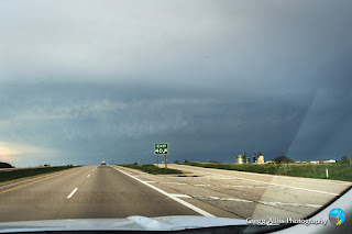
#4. Severe-warned storm cell as seen from US Highway 151 near Dodgeville, Wisconsin on May 13, 2022.


#5. Maturing supercell seen from US Highway 61 near Kieler, Wisconsin on June 15, 2022.


#6. Tornado-warned cell as seen from Blue River Road in Iowa County, Wisconsin on June 15, 2022.


#7. Brilliant sunrise from Marion, Iowa on June 17, 2022.


#8. Rare crepuscular arch stretching from west (left) to east (right) emanating from a severe-warned cell near  Cedar Rapids, Iowa on June 28, 2022. 


#9. Approaching shelf cloud panorama as seen from Cedar Rapids, Iowa on July 5, 2022.


#10. Storm cell with crepuscular arch as seen from Cedar Rapids, Iowa on August 3, 2022.


#11. Western wildfire enhanced sunset as seen from Marion, Iowa on September 8, 2022.


#12. Rising Hunter's Moon as seen from North Marion Road north of Marion, Iowa on October 10, 2022.


#13. Full lunar eclipse in the western sky as seen from Radio Road, northeast of Marion, Iowa on November 8, 2022. This was the second of two full lunar eclipses occurring during the year, the other one on May 15-16.


#14. Moon/Mars occultation sequence from Cedar Rapids, Iowa on December 7, 2022.


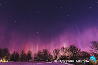
#15. Brilliant light pillars seen from Bowman Woods Park in Cedar Rapids, Iowa during the early morning hours of December 18, 2022. Air temperature was 9 degrees F.


#16. Christmas Eve planetary alignment shortly after sunset as seen from Cedar Rapids, Iowa on December 24, 2022.


Read more...

Warm Air, Warm Sky

Sunday, January 1, 2023


Air temperatures at 5:08 pm CST, Thursday, December 29, 2022 in Cedar Rapids, Iowa hovered at a balmy 54 degrees F, down from a high of 60.4 degrees about three hours earlier. The sunset at this time was also warm, as seen in these images looking west from Bowman Woods Park. Just a few days earlier wind chills here registered at around -20 degrees F.


5:09 pm. Similar shot but in panorama form. The altocumulus clouds took on an almost reptilian scale appearance. Nikon D7200 DSLR camera.


5:13 pm. iPhone 11 camera rooftop panorama capture.


Read more...

Alignment Check

Monday, December 26, 2022


5:13 pm CST, Saturday, December 24, 2022. 0.3 second exposure at f/2.8, ISO 200, 11mm focal length. Christmas Eve planetary alignment panorama, looking east (left) to west (right) from the grounds at Noelridge Christian Church in Cedar Rapids, Iowa: -1.43 magnitude Mars, -2.41 magnitude Jupiter (top), 0.81 Saturn, Moon, -0.28 Mercury and -3.91 Venus (just above tree). Air temperature was 6 degrees F, with wind chills around -20 degrees F. After just a few minutes out in the frigid elements, my body started to shiver uncontrollably--forcing me to high-tail it back to my nearby running vehicle to warm up, then emerge to go back out again. I had to do this twice. I was happy I was able to include all the visible planets (and moon) into a single panoramic image, because of my haste to get back to warmth!


                      Identical image from one at top, but with planet identifications. The planets Uranus, Neptune and the dwarf planet Pluto were also present, but too dim to see. Their positions are shown in this image as well. The following evening (Christmas Day) offered an even better alignment viewing opportunity for this location, but cloud cover and snowfall would prevent it. Nikon D7200 DSLR camera.


Read more...

Blizzard Bluster

Friday, December 23, 2022


Talk of an impending blizzard with possible 10-15 inches of snow, 50 mph wind gusts and sub-zero temperatures in the days leading up to its arrival in Eastern Iowa had residents on edge. As weather conditions would play out in the days ahead, the blizzard was indeed potent, but not to the degree of some of the dire forecasts out there. The Radarscope image above shows the storm's progress at 3:41 pm CST, Wednesday, December 21, 2022, and again at 5:54 pm (below). The yellows and greens in Central Iowa show the more intense areas. The National Weather Service (NWS) issued a Blizzard Warning for Eastern Iowa on Wednesday evening, an upgrade from the previous issuance of a Winter Storm Warning.


8:23 pm. The image above looks west from Boyson Road at the Boyson Park trailhead parking lot during the early phase of the blizzard warning. The colorful streaks along the road at right are long exposure headlights and taillights. 10 second exposure at f/20, ISO 100, 24mm focal length. Air temperature was 21 degrees F.


Weather conditions for 8:36 pm.


9:00 pm. Looking northeast at Christmas lights on Timber Creek Drive, as seen from Boyson Road during the initial phase of the blizzard. 2 second exposure at f/9, ISO 100, 18mm focal length.


9:01 pm. Similar image. 2.5 second exposure at f/7.1, ISO 100, 30mm focal length.


Radarscope image for 8:03 am CST, Thursday, December 22, 2022. I had headed north of town to capture rural blizzard images. The image above shows that at this point most of the intense areas of snow (yellows and greens) had already passed east of my location (target icon).


8:04 am. Eastbound on County Home Road (E34), just west of North Marion Road/North Tenth Street, north of Marion, Iowa.


8:06 am. Looking south from North Marion Road, just north of County Home Road.


Weather conditions for 8:06 am.


8:08 am. Looking south from North Marion Road, just north of County Home Road, with snowplow in the distance.


8:09 am. Looking southwest from North Marion Road, just north of County Home Road, with farm house at right.


8:11 am. Southbound on North Tenth Street, just south of County Home Road.


8:11 am. Southbound on North Tenth Street, just south of County Home Road.


8:12 am. Southbound on North Tenth Street, just south of County Home Road.


8:15 am. Looking north from the parking lot at Lowe Park in Marion, Iowa.


3:24 pm CST, Thursday, December 22, 2022. The skies had sufficiently cleared enough to allow this vivid sun dog to appear in the western skies. This image was captured from Alburnett Road in the Bowman Meadows housing development. Air temperature was -8 degrees F, with wind chills near -30 degrees F. My bare fingers instantly froze upon air exposure capturing this shot.


9:02 am CST, Friday, December 23, 2022. High winds and fast moving clouds did not prevent a morning sun dog from showing through. This image looks southeast over the Brentwood Drive NE neighborhood of Cedar Rapids, Iowa, as seen from Bowman Woods Park. Air temperature was -8 degrees F, with some wind gusts creating -40 degree wind chills. The snowfall in Cedar Rapids from the start of this storm on Wednesday was about 5 inches.


Nightfall in Cedar Rapids on December 23. Blizzard conditions continue with blowing snow. This image looks south from Brentwood Drive NE at 5:13 pm and is a (StarStax2) 5-image stack, with each image an 8 second exposure at f/11, ISO 100 and 18mm focal length. Nikon D7200 DSLR camera.


Sidenote: While standing outside to capture the Friday morning sun dog, I observed how high winds impacted the rear of houses along the eastern border of Bowman Woods Park. Snow carried along during high speed winds gusts visually showed how wind in open areas of the park (background and right) slammed unhindered into the back of houses, while houses downwind from where I was standing (foreground) were largely protected by the large hill (toward the left in this image). This provided a visual confirmation to the notion that houses protected by the hill survived the derecho winds of August 10, 2020 without much damage while those in open areas did not.


Read more...

Acid Reflux Led Me to Ice Pillar Phenomenon Viewing

Sunday, December 18, 2022


I woke about 12:15 am on Sunday, December 18, 2022 with an acid reflux-induced cough starting up. Rather than coughing in our bedroom I rose to do so in the kitchen. While in the kitchen I decided to step outside to check out the night sky. I gasped as I observed shafts of light all over the sky. My initial thought was an auroral storm was taking place, but curiously, my aurora alerts app showed nothing significant. It wasn't until about four hours later after my images had been processed and sent to the National Weather Service (in Des Moines, Iowa), that I was corrected and given the true nature of the event--Ice Pillars (also known as Light Pillars). Ice pillars are defined as optical illusions created from lights reflecting off the surface of horizontal ice crystals low in the atmosphere. These plate-like hexagonal shaped crystals are suspended in the air for a period of time, as is freezing fog. When the crystals get low enough in the atmosphere, they create the illusion of the ice pillars. Light sources that illuminate the crystals from below can be street lamps or other brightly colored lights over a city. The image above looks north over Bowman Woods Park in Cedar Rapids, Iowa at 12:43 am CST, and is a 5 second exposure at f/2.8, ISO 500, 11mm focal length. Ice pillar colors have been enhanced. Air temperature was 9 degrees F, with wind chills at zero.


12:45 am. Panorama looking north (center) over Bowman Woods Park. 5 second exposure at f/2.8, ISO 500, 11mm focal length. 


12:46 am. Similar image looking northwest.


12:52 am. Looking southeast over Brentwood Drive NE neighborhood. 8 second exposure at f/2.8, ISO 500, 11mm focal length.


12:56 am. Panorama looking northwest (center) from another area of Bowman Woods Park. Bowman Woods Elementary School is seen at lower left. 4 second exposure at f/2.8, ISO 500, 11mm focal length.


12:56 am. Looking northeast from same area. Ursa Major (The Big Dipper) can be seen at center.


1:00 am. Looking southeast over Brentwood Drive NE neighborhood. 3 second exposure at f/2.8, ISO 400, 11mm focal length. As it turned out, I was "fortunate" that my acid reflux allowed me to be awake for this event! By 3:00 am the pillars had mostly disappeared. 


7:45 am. Sunrise several hours later. A sun pillar is shown flanked by sun dogs as seen from the parking lot at Noelridge Christian Church. The hexagonal ice crystals were still present in the atmosphere to create this atmospheric light variation. Sun pillars (and moon pillars) are created in exactly the same way as ice pillars, but with the light of the sun or moon creating the shaft. Air temperature here was 5 degrees F. Nikon D7200 DSLR camera.


Read more...

Live Nativity Weather--Mild And With An Added Bonus

Friday, December 16, 2022


Noelridge Christian Church
in Cedar Rapids, Iowa held its Live Nativity event on Wednesday, December 14, 2022--typically a time of year that is cold and snowy. Not so this year. Early evening temperatures hovered around 40 degrees F. An added bonus was fiery clouds in the western sky, enhanced by the sun from an open gap along the horizon. The image above was captured at 4:59 pm CST, an hour before the start of the Live Nativity event.


5:06 pm.


5:22 pm. Five shot stitched panorama image. Luminaries line the parking lot. 0.4 second exposure at f/3.5,  ISO 200, 18mm focal length. Nikon D7200 DSLR camera.

Read more...

  © Blogger template On The Road by Ourblogtemplates.com 2009

Back to TOP