Let It Storm? Let It Storm? Let It Storm?

Tuesday, December 29, 2015


This day on Wednesday, December 23, 2015 should have been a white snowy landscape in Iowa. Instead, it was 55 degrees F with a nearly identical dew point. Even more amazing was the fact that the Storm Prediction Center issued Tornado Watch 561 covering areas in three midwestern states just before 3:00 pm CST. The watch box's northern boundary stretched nearly to Cedar Rapids, Iowa.


Though no tornadoes would materialize in the Cedar Rapids area, an approaching thunderstorm (above) was seen in this image of the SW sky from Bowman Woods Park at 3:33 pm.


At 3:35 pm, a bank of convective clouds, more indicative of spring or summer, stretched across the northwest sky, seen here behind Bowman Woods Elementary School.


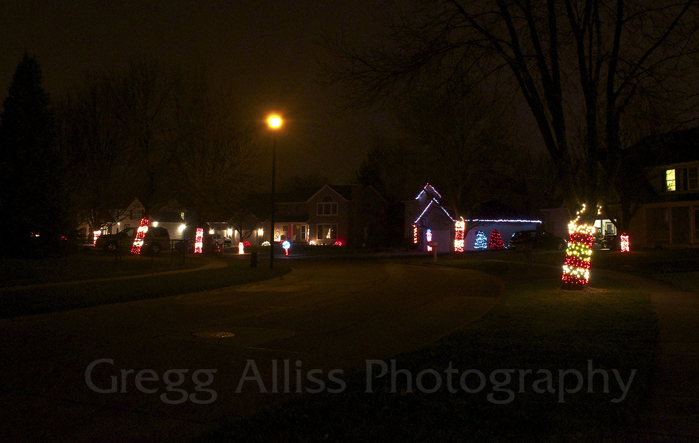
The thunderstorm is almost upon this location on Brentwood Drive NE at 4:43 pm. Christmas decorations in the foreground of the image give the moment an almost surreal appearance.


A testament to the abnormal weather conditions of the month and day is this image of my Vantage Vue weather station at 4:08 pm. 22 confirmed tornadoes in five states--two rated at EF3--would drop from this system. A Particularly Dangerous Situation (PDS), infrequent even in the springtime, was issued by the SPC for parts of Louisiana, Arkansas, Mississippi and Tennessee during the event. Nikon D5000 DSLR camera.

Read more...

Dazzling In Drizzle

Tuesday, December 22, 2015


These three images, all from the vicinity of Bowman Lane and Bowman Court NE in Cedar Rapids, Iowa, were shot from 7:03-7:06 pm CST, Monday, December 21, 2015. A light, falling drizzle only slightly subdued the dazzle of the neighborhood Christmas lights displayed there. A three exposures were just over a second long at f/13, 2500 ISO and 18mm focal length. Nikon D5000 DSLR camera.

Read more...

Brilliance In A Bleak Winter Sky

Thursday, December 10, 2015


In an otherwise bleak "hazy shade of winter" sky on Wednesday evening, December 9, 2015, a cloud opening in the west allowed a brief, but brilliant sunset color to pour through. These two images were captured from Bowman Woods Park in Cedar Rapids, Iowa. The image above was shot at 4:42 pm, CST.


This photo, a three-image stitch, was captured at 4:43 pm. A minute or so later, the cloud aperture closed and with it the splash of color. Actual sunset time was 4:35 pm. Nikon D5000 DSLR camera.

Read more...

Dusting The Creekside

Tuesday, November 24, 2015


Dry Run Creek in Boyson Park, near the Marion and Cedar Rapids, Iowa boundary, was the setting for these three images. All three look west. Snow had been falling for nearly a half-hour and was beginning to dust solid objects surrounding the creek. When the snow system had exited the next day, some seven inches fell here. Capture times: Bottom image, 4:03 pm CST, Friday, November 20, 2015; Middle image, 4:06 pm; and top image, 4:07 pm. Nikon D5000 DSLR camera.

Read more...

Before The Snow Flew…And During

Monday, November 23, 2015


This image, a two-photo stitch, looks north from Alburnett Road, about .8-mile north of County Home Road, and north of Marion, Iowa at 3:26 pm, Friday, November 20, 2015. Miniature flakes of snow had just begun to filter downward as the first significant snowstorm of the season approached.


32 minutes later, this was the scene at Boyson Park near the border of Marion and Cedar Rapids, Iowa. Heavier snow was now falling, and when the system vacated the area the next morning, some 7 inches of snow had covered the ground. Air temperature for the top image was 33 degrees F. By 10:50 pm the following day (November 21), air temperature was 7 degrees F. Nikon D5000 DSLR camera.

Read more...

November Severe Weather

Thursday, November 12, 2015


With the SPC forecasting severe weather potential for southern Iowa and northern Missouri two days in advance, storm initiation finally began in western Iowa before noon on Wednesday, November 11, 2015. Tornado Watch 535 was issued for much of eastern Iowa at 3:20 pm CST. A mix of strong CAPE, wind shear and warm air contributed to this unusual November severe event. The above image looks west at an advancing line of severe storms at 4:54 pm from Nutmeg Avenue at 220th Street (County Road G36), one mile east of Highway 1 in central Washington County, Iowa.


As the storm passed overhead, torrents of blinding rain made driving on 220th Street extremely difficult. We witnessed an SUV drive slowly off the road and into the ditch to the left, miraculously recover and pull back up to the road surface, only to slowly go off and into the ditch at right. A small parking oasis just before Highway 1 allowed us to pull into it to wait out the rain and hail. I could not see the hail clearly in the dark, but judging by the impacts on our vehicle estimated it to be penny size. The middle image--a video frame capture--shows a parked dump truck at 5:02 pm, which served as sort of a directional beacon which drew us to the safety of the fortuitous parking area.


This radar image graphic shows our position near the time of the middle image. Small hail cores can be seen in the area, colored in lavender. The early darkness of November made photographing the storm a challenge. Nikon D5000 DSLR camera.

Read more...

Growing Glow In The East

Monday, November 9, 2015


An ever-increasing glow in the eastern sky is seen here at 6:18 am CST, Monday, November 9, 2015, from Progress Drive in Hiawatha, Iowa. This image was captured a half-hour before sunrise and features a waning crescent moon. Air temperature was a crisp 43 degrees F. iPhone 6 Plus camera.

Read more...

A Little More Than Expected

Wednesday, October 21, 2015


Earlier forecasts for Tuesday afternoon, October 20, 2015 in Cedar Rapids, Iowa called for "light showers possible." A little more than that occurred. Fast moving, but prolonged thundershowers/thunderstorms dropped around a half inch of rain in some places and was accompanied by high winds and vivid lightning shows. Hastily revised forecasts even called for "pea size" hail possibilities, but none were encountered here. The unexpected weather system provided much needed moisture for the area, which was under a fire hazard advisory the previous day due to very dry conditions and wind. This image, a two-photo stitch, looks northwest toward Bowman Woods Park around 6:30 pm CDT. Air temperature was 60 degrees F. Nikon D5000 DSLR camera.

Read more...

Morning Roll Call

Monday, October 12, 2015


Rising before dawn on Saturday mornings isn't necessarily common practice for most folks, but the clear skies and a rare celestial conjunction made it more than worth the while on October 10, 2015.
Lining up in an arc from ground up were four planets and a thin crescent moon. Both these images look east from White Road, about a half-mile east of North Alburnett Road, and about three miles north of Marion, Iowa. A family dog from a nearby farmstead did not care for my presence and barked into the darkness nearly the entire time I was there. The above image, shot at 6:15 am CDT, is a 3-second exposure at f/5.6, 500 ISO and 22mm focal length.


This image, captured five minutes later, is a closeup view of the lineup, which includes from bottom left to top right: the planet Mercury (magnitude 0.54), the moon, Jupiter (-1.74), Mars (1.76) and Venus (-4.47). It is a 4-second exposure at f/8, 1600 ISO and 35mm focal length. A chilly air temperature of 41 degees F made for numb fingers! Nikon D5000 DSLR camera.

Read more...

Dome Cap

Monday, October 5, 2015


Stratus clouds squeeze the sky ceiling down to mountain tops as seen from the observation tower at Clingmans Dome in the Great Smoky Mountains National Park on the afternoon of Thursday, September 17, 2015. In the views looking southwest above, the elevated walkway leading to the observation tower can be seen in the foreground. The top image was captured at 2:53 pm EDT, and the image directly above earlier at 2:34 pm.


This view, looking toward the northeast, shows the approach to the observation tower platform which affords a 360-degree vista of Appalachian Mountains. 2:56 pm. Half of the platform is claimed by the state of Tennessee and the other half by North Carolina. Altitude at the platform in 6,675 feet. Nikon D5000 DSLR camera.

Read more...

In Proper Alignment

Thursday, October 1, 2015


Clear and cool conditions (44 degrees F) provided for excellent viewing of three planets and a bright star which formed an arc alignment in the east sky on the morning of Thursday, October 1, 2015. Location here was Progress Drive in Hiawatha, Iowa. The glittering celestial objects, suspended above the growing glow of dawn at 6:13 am CDT are, from bottom-to-top: Jupiter (-1.72 magnitude), Mars (1.77), Regulus (in Leo, 1.34), Venus (-4.52). Nikon D5000 DSLR camera.

Read more...

West Sky, Best Sky- At Least At This Moment

Wednesday, September 30, 2015


The east sky on the evening of Sunday, September 27, 2015 featured a rising supermoon and later a total lunar eclipse, but the west sky was wowing viewers as well. All three of the images seen on this post were captured from the grounds at Echo Hill Presbyterian Church in Marion, Iowa. The above image shows Canada geese in flight in their characteristic "V" formation, heading west at 7:07 pm CDT.


This image captures the sunset with the church's silhouette in the foreground. 7:17 pm.


Seven minutes later crepuscular rays add to the beauty of the sunset. Actual sunset time was 6:55 pm. Nikon D5000 DSLR camera.

Read more...

Super Moon, Super Eclipse

Monday, September 28, 2015


Most of the day on Sunday, September 27, 2015 was cloudy, with only intermittent breaks. But as luck would have it on the big supermoon/eclipse day in Eastern Iowa, the cloud cover dissipated just in time! The image above looks east toward a farmstead just west of Lyons Drive in Marion, Iowa at 7:04 pm CDT. The full moon was closest to earth on this day for all of 2015.


The above image is an eclipse sequence. Time for each separate image is from left: 7:53 pm,
8:09 pm, 8:22 pm, 8:30 pm, 8:35 pm, 8:41 pm, 8:51 pm, 9:47 pm.


This capture is a close-up of the eclipsed image at far right above. It is a 2 second exposure at f/13, 3200 ISO and 200mm focal length. Nikon D5000 DSLR camera. The "blood moon" gets its appearance because the sun's light leaks around the edge of the Earth and passes through its atmosphere during the eclipse. The moon was in the Earth's "umbra"shadow for one hour and 22 minutes, making it a true total lunar eclipse. The next supermoon eclipse won't occur until 2033!

Read more...

Milky and Smoky

Tuesday, September 22, 2015


A recent vacation which included east Tennessee produced these three images during a a clear night in the Chilhowee foothills of the Great Smoky Mountains, about 15 miles southeast of Knoxville. The two Milky Way images above, both shot around 9:19 pm EDT, are 20-second exposures at f/3.5, 2500 ISO and 18mm focal length. The house seen in the foreground was "light painted" with a flashlight for about a second or so. Both images look southwest.


This starry sky scene was captured nearby around 9:00 pm EDT, looks east, and is a 30-second exposure. Nikon D5000 DSLR camera.

Read more...

Not So Super Supermoon

Sunday, August 30, 2015


Heavy cloud cover at moonrise in the Cedar Rapids/Marion area of Iowa (7:41 pm) completely prevented any observation or photo capture of the "supermoon" on the evening of Saturday, August 29, 2015. All hopes of a really fat, golden moon hanging on the horizon of a rolling farm field were then doomed. Even the possibility of catching it in "reverse" at moonset the next morning never happened as the land was shrouded in fog. The above image was all that was possible for me as the moon peeked in and out of cloud gaps high above the landscape at 8:53 pm CDT Saturday evening. The pic is a combined image with the clouds shot as a 1.3-second exposure at f/5.6, 1600 ISO and 200mm focal length, and the moon a 1/400-second exposure at f/8, 3200 ISO and 200mm focal length. Better luck next supermoon, which occurs here on September 27. A lunar eclipse occurs with this one, so we will have a "super-blood moon." Nikon D5000 DSLR camera.

Read more...

Wild Goose Chase?

Wednesday, August 19, 2015


Tornado Watch 494 was issued for eastern Iowa and western Illinois by the SPC at 1:30 pm CDT on Tuesday, August 18, 2015. A report of a tornado was made from near Stanwood, Iowa, in northern Cedar County around 3:15 pm, just as I was arriving home in Cedar Rapids from work. At this time the severe weather was already well east and pushing farther east as I scrambled to catch it. Some 20 miles away, the storm suddenly weakened below severe levels. The Nikon D5000 DSLR camera image above shows a line of strong--but no longer severe--storms in western Jackson County as seen from state highway 64 in southeast Jones County at 4:24 pm CDT.


My attention was quickly given to a new severe storm warning emanating from my weather radio, this one in Scott County to the south (see above Radarscope image). Thoughts here were the opportunity to salvage the venture. I drove east to Maquoketa, then south on US Highway 61, in an apparent intercept path.


About 15 minutes later this storm too detensified below severe levels and the chase was done. Yes, but not without drama--just north of Eldridge, Iowa on Highway 61 around 5:15 pm, the heavens opened and unleashed a torrent of rain (Go Pro Hero video frame capture above). At one point I could barely see where I was driving and braced for that dreaded crash from behind. Luckily it never came. Many cars, as seen in the image above, pulled over to the side of the road, but this was only slightly safer, or maybe not AS safe? This image was captured when the rain had actually slightly let up. The chase produced nothing significant in the 170 miles driven. Photos weren't even that great because the gray and grayer sky lacked much contrast. Wet wild goose chase!

Read more...

Two Bright Ones

Thursday, August 13, 2015


Ya snooze ya lose. The early morning hours of Wednesday, August 12, 2015 in Cedar Rapids, Iowa provided crisp, clear, weather conditions for the Perseids meteor shower, one day ahead of its peak. And indeed I went outside for a look and witnessed several bright meteors in the short time I was out there. Weather forecasts for the following few days called for the same, so I opted to photograph the shower during its "official" peak the following night. As I staggered outside after 3:15 am on Thursday, August 13, a high veil of cirrus clouds covered all but the brightest stars. Momentary letups in the cloud cover allowed for two of the only three meteor streaks I saw to be captured by my camera. The farthest left meteor in the image above was shot at 3:59 am (and combined with the image containing the other meteor), photographed at 4:04 am. The meteor's point of origin--the radiant--emanated from the namesake constellation Perseus, located out of the picture above. At right is the constellation Auriga. Image looks northeast from Bowman Woods Park in Cedar Rapids. It is a 30-second exposure at f/3.5, 500 ISO and 18mm focal length. Nikon D5000 DSLR camera.

Read more...

Fire And Rain

Monday, August 10, 2015


This rural Shueyville, Iowa bonfire, set ablaze for entertainment purposes for a large group of spectators, was timely. When the majority of the large blaze--whose smoke rose high into the evening sky--finally wound down, sprinkles then a steady rain began to fall which lasted all night and into the next morning. Raindrops in the nearby pond can be seen in the top image, captured at 8:52 pm CDT, Saturday, August 8, 2015. It is a one second exposure at f/13, 200 ISO and 38mm focal length. The middle image, shot at 8:53 pm, is a 6-second exposure at f/13, 200 ISO and 18mm focal length. Bottom image, photographed at 8:57 pm, is a one second exposure at f/8, 2000 ISO and 18mm focal length. Nikon D5000 DSLR camera.

Read more...

Tassels In The Sky

Friday, August 7, 2015


Passing storms clouds and clouds seen in the distance are offered in these images using a corn field as foreground piece. All three photos look east from Yucca Avenue, less than 2 miles east of Ainsworth, Iowa on the evening of Tuesday, July 28, 2015. The top image, captured at 7:18 pm CDT, includes the moon--three days before it reached its "Blue Moon" status. The middle image is dominated by a large rain shaft and was photographed at 7:25 pm. The bottom image, shot at 7:30 pm, frames a distant cumulus tower. Nikon D5000 DSLR camera.

Read more...

Up, Up and Away

Thursday, August 6, 2015


Seen here from Fay Clark Park in Hiawatha, Iowa, cumulus towers some 50 miles distant were rising into the fading sunlight on Sunday, August 2, 2015. Images look south and southeast. In the top image (8:02 pm CDT), the towers are nearly vertical. In the middle image (8:06 pm) they begin to interact with stronger winds aloft. Some of the structures are bent nearly horizontally in the bottom image (8:14 pm). Severe weather was occurring behind the towers, over 100 miles away near the Iowa/Missouri border. Nikon D5000 DSLR camera.

Read more...

Same Cell, Three Different Locations

Wednesday, August 5, 2015


This isolated storm cell, with its classic cumulonimbus characteristic, billowed upwards of 45,000 feet in south-central Poweshiek County Iowa on the evening of Sunday, August 2, 2015. Captured for this posting are images of the cell from three different locations. The image above was shot from Archer Drive and Bowhunter Drive in Marion, Iowa around 7:44 pm CDT. The cell was about 57 miles to the southwest.


 Location here was about 3.7 miles to the west of the top image, on Boyson Road over Interstate 380 in Hiawatha. Time was 7:55 pm.


Four minutes later and one mile farther west, captured from Fay Clark Park in Hiawatha. Nikon D5000 DSLR camera.

Read more...

  © Blogger template On The Road by Ourblogtemplates.com 2009

Back to TOP