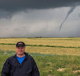
Pileus Cap On April 27 Storm Cell

Thursday, April 30, 2020


This storm cell had passed east over my location at Brentwood Drive NE in Cedar Rapids, Iowa on the evening of Monday, April 27, 2020. As it did so, it acquired a pileus cap (right) at 6:25 pm CDT. Pileus are short-lived formations created by strong updrafts at lower altitudes acting on moist air above, causing the air to cool to its dew point. Moist pileus are associated with severe weather, but this particular occurrence was not. Weather conditions at the time were: 74 degree F temperatures, 52 degree dew point and 47% humidity. Nikon D7200 DSLR camera.


Radar capture corresponding to the same time as the photograph at top. Arrow points to the area of the pileus cloud. 

Read more...

Didn't Happen

Wednesday, April 29, 2020


These were the Storm Prediction Center's (SPC) Categorical, Tornado, Wind and Hail convective outlooks posted at 7:26 AM CDT on Tuesday, April 28, 2020. The eastern half of the state of Iowa was included with definite potential for severe weather, and the day's scenario looked reminiscent of the setup on May 24, 2019 where instability was greater in Texas and Oklahoma in the south but with greater wind shear in southeast Iowa in the north. That setup would produce a tornado southwest of Iowa City. This time, The Weather Channel was setting TorCons of 3 in eastern Iowa (30% chance of a tornado in a 50 mile radius), and Extreme Meteorologist Reed Timmer had pegged tornado chances for the Dubuque and Davenport areas in a morning briefing.


Garden variety thundershowers moved through the Cedar Rapids area around 1:00 pm, followed by some partial clearing. By 4:00 pm a small but promising cell began to form near Iowa City, moving northeast. I quickly got on US Highway 30 east, with the expectation that this cell would go severe and I would be able to intercept it in time. In reality though, by the time I reached it, it began to weaken. In fact, despite all earlier forecasts, NOWHERE in the state of Iowa were there any watches or warnings the entire day. In the image above, I am eastbound on US Highway 30, about .75-mile east of the town of Mechanicsville, Iowa, looking toward the weakening cell at 4:48 pm.


Looking northeast at the cell at 4:49 pm.


4:53 pm. Eastbound on US 30 just east of the town of Stanwood and 5 miles west of Clarence, Iowa. I would continue east until I was located between the towns of Clarence and Lowden before deciding to return home, realizing the show was over for the day. A major bust in Iowa. Nikon D7200 DSLR camera.


Radar capture for 4:55 pm. The large area at right was the object of my intended intercept. The small cell at lower left formed and then dissolved within a few minutes. The black arrow indicates storm movement.

Read more...

Bullish on the Moon, Venus and Aldebaran

Sunday, April 26, 2020


A waxing crescent moon, the -4.51 magnitude planet Venus (at top), and of course the 0.84 magnitude star Aldebaran were in Taurus (The Bull constellation) on the evening of Saturday, April 25, 2020, forming a right triangle of sorts. These captures look west from Bowman Woods Park in Cedar Rapids, Iowa. The image above, captured at 8:45 pm CDT, is a 0.6 second exposure at f/5.3, ISO 640 and 48mm focal length. Below is a 0.6 second exposure at f/5.6, ISO 800 and 55mm focal length, captured at 8:47 pm. Nikon D7200 DSLR camera.


Read more...

Much Ado About Nothing

Thursday, April 23, 2020


Churning mammatus-like cloud formations were seen approaching in the western sky from Bowman Woods Park in Cedar Rapids, Iowa on Wednesday morning, April 22, 2020. Despite the ominous appearance, however, it dissipated into a full overcast within minutes and only produced some light rain. The three images posted here were captured around 7:30 am CDT. Nikon D7200 DSLR camera.


Radar capture corresponding to the time of the cloud formations shown above, showing the garden variety weather system approaching.

Read more...

2020 Lyrids Meteor Shower

Wednesday, April 22, 2020


I set my alarm for 1:30 am on Wednesday, April 22, 2020 to view the Lyrids Meteor Shower peak. A weather forecast predicted clouds arriving after 3:00 am, so I chose this slightly less desirable earlier time. At 1:30 am the sky was clear but hazy. Temperature was 42 degrees F and 58% humidity. My Nikon D7200 DSLR camera was set up from my back deck on a tripod with a remote cord to continuously capture shots to stack together as star trails later in post processing. The image above looks northeast from Brentwood Drive in Cedar Rapids, Iowa. It is a 10 second exposure at f/2.8, ISO 800, 16mm focal length, captured at 1:45 am CDT. An additional fainter meteor streak (from 2:10 am) has been added to the image at right center, just right of the radiant constellation Lyra, featuring its bright star Vega.


This image is a combination of 192 separate images, stacked together in StarStaX 2, creating a star trails image. Each of the images are 10 second exposures at f/2.8, ISO 800, 16mm focal length. Total photographing time was from 1:38-2:11 am. The annual Lyrids meteor shower is created when during late April our Earth crosses through debris from the orbital path of the Comet Thatcher. The debris enters Earth's atmosphere at 110,000 miles an hour and are vaporized into the bright trajectories of light we see from the ground.

Read more...

A Definite Climate Change

Friday, April 17, 2020


Winter Storm Sadie began rolling across the state of Iowa on Thursday, April 16, 2020. The sizable and unusual snow system for the season reached Cedar Rapids around 11:00 pm CDT. Above is a radar capture corresponding to 4:40 am on April 17, with heavier precipitation shown well over the city. The white arrow indicates storm movement. Though light flurries continued after 7:00 am, I recorded a total of 3.5 inches of snowfall from my location on the eastern border of Bowman Woods Park in Cedar Rapids.


The image above and following images were captured from my backyard or in the park from 6-7 am Friday morning. By 2:00 pm, with temperatures having climbed into the upper 40s, all of the snow was gone. Nikon D7200 DSLR camera.


Weather station showing conditions at 6:48 am after most of the snow had fallen.

Read more...

Winter's Spring Ambush

Tuesday, April 14, 2020


Didn't think it could snow at 44 degrees Fahrenheit? While hiking along the Boyson Park Trail in Marion, Iowa on Thursday, April 9, 2020, it was a seemingly warm and sunny springtime jaunt. Intermittent clusters of swirling clouds suddenly began to roll over me, with surprising results: a mild snow squall emanated from the first, lasting about ten minutes--in 44 degree temperatures. The image above from the trail shows the churning snow cloud after it had passed east of me at 12:21 pm CDT.


A panoramic shot of the cloud from the same time. Sunlight again broke out and then went back under with another snow squall on my return walk. iPhone 6 Plus camera.

Read more...

Easter Morning Sunrise Sky

Monday, April 13, 2020


The sun peeks through a veil of clouds on Easter Sunday morning at 8:04 am CDT (above) and 8:07 am (below), April 12, 2020. The location was at Noelridge Christian Church on C Avenue NE, just north of Boyson Road in Cedar Rapids, Iowa.


The cloud would increase and rain would arrive hours later. Nikon D7200 DSLR camera.

Read more...

A Plague of Hail

Thursday, April 9, 2020


So let it be written. So let it be done. First of all, I wasn't expecting any thunderstorms at all for Cedar Rapids, Iowa on Tuesday, April 7, 2020. The Storm Prediction Center (SPC), had the city just barely inside the lightest outlook for thunderstorms, and had only a 5% chance for hail in an area stretching east of Davenport (top graphic). A day later the SPC posted a preliminary report for actual hail occurrences (bottom graphic, above).


Around 5:10 pm CDT, a small area formed some 28 miles west of Cedar Rapids, near the towns of Dysart and Garrison, and began to track east. At 5:27 pm it had intensified (radar capture, above left) but was not severe warned. By 5:35 pm it was (above right).


Of course now I began to take closer notice of the situation and set up my spotting observations from my backyard on the east edge of Bowman Woods Park in Cedar Rapids. Above is what the underside of the storm's anvil looked like facing west at 5:42 pm, as it stretched overhead toward the east.


A similar capture looking west at 5:48 pm, with the anvil beginning to block out the sun.


5:49 pm. Severe-warned storm cell is exhibiting a very vigorous updraft.


5:53 pm. Similar capture, wider view.


5:54 pm radar capture as the storm cell was over Cedar Rapids. Though severe warned, this storm did not affect much in my viewable area, and passed on leaving a feeling that the threat for anything further was over.


Not so! At 6:15 a new storm cell now materialized just west of Cedar Rapids, trailing the earlier one. Air temperature was 78 degrees F, 60 degree dew point with 54% relative humidity.


By 6:30 pm, ominous amateur and weather radio reports told of significant hail associated with the new storm cell to the west. Above, my view of the west sky overlooking Bowman Woods Park at 6:35 pm--a classic calm before the storm scenario--as the hail would come about three minutes later.


Radarscope capture closely corresponding to the photograph above it.


And hail it did! This image from 6:40 pm shows hail pelting down in our backyard. Falling hail started as pea size, grew to penny size, then golf ball, then a few with maximum sizes of 2.5 inches!


Radar capture for 6:40 pm.


Backyard hail at 6:44 pm, near the end of the event.


6:45 pm. A handful of harvested golf ball size hail. Note the conglomerate dimpled appearance of these stones.


6:52 pm. The hail storm finally over and a safe view of the leftovers.


6:54 pm. The trailing edge of this potent storm, looking west. The trailing edge slid east to my south and caused no further mayhem here.


Aftermath: Hail stones with various shapes and compositions, at 7:05 pm (above, top), and two of the largest stones gathered at 7:15 pm (above, bottom).


7:10 pm. A view of the departing storm system to my east, seen over our house roof.


7:24 pm. Departing severe-warned storm cell looking more dramatic as it created distance. At this moment the cell was some 20 miles distant to the southeast, just north of Mechanicsville, Iowa in Cedar County.


Corresponding radar capture to the images above and below.


7:31 pm. Panorama captured from Bowman Woods Park, looking east. The area at right is part of the southern edge of the system which missed this location.


7:32 pm. Panoramic view of the trailing edge of the storm system as it departed east, looking south from Bowman Woods Park.


Curiously, an eerie and dense ground fog enveloped the area following the storm's departure. This image looks east along Boyson Road at Brentwood Drive NE in Cedar Rapids, near the border with the neighboring community of Marion, Iowa at 7:43 pm. Weather conditions at this moment: 66 degrees F, 58 degree dew point and 84% relative humidity. Nikon D7200 DSLR camera.


POSTSCRIPT: The largest discovered hailstone from our backyard is compared to an old tennis ball.


The one and only hail damage casualty from home. Superficial dents to the roof of my car excluded, it was to the wind vane arrow of my Davis Instruments Vantage Vue weather station, which was broken off. What make this truly amazing is the fact that the wind vane shaft is such a small target, a mere 1/4 inch-wide and protrudes only two inches out from under the main unit. (Surprisingly the main unit and the fragile anemometer cups survived intact). My first thought was that the wind vane suffered a wild chance hit, but now as I ponder the volume of hail that was falling at the time, I guess I should not be surprised. Storms have not been kind to my roof-mounted weather stations. My former weather station, an Oregon Scientific WMR968 unit, was damaged beyond repair by a falling tree branch on June 29, 2012. The largest hailstones from the April 7, 2020 storm may be the largest I've ever witnessed! iPhone 6 Plus camera.


7:35 pm CDT, Tuesday, April 7, 2020. My weather station with the backdrop of the departing storm system whose hail damaged its wind vane. Nikon D7200 DSLR camera.

Read more...

  © Blogger template On The Road by Ourblogtemplates.com 2009

Back to TOP