Mars in Opposition, Moon in Full

Friday, July 27, 2018


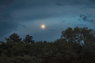
The planet Mars officially reached opposition--when it was at its closest approach to Earth (35.8 million miles) and with Earth being directly in the middle of the Sun and the red planet--at 2:50 am CDT, Friday, July 27, 2018. Mars was at its brightest from Earth since 2003. Accompanying the -2.78 magnitude Mars (left) in the image above, was a full moon and 0.16 magnitude planet Saturn (lower right). The camera faces SSW at Hampshire Circle, just north of Prescott Lane and just south of East Robins Road in Marion, Iowa. Air temperature was a cool 55 degrees F. This image is a Starry Landscape Stacker stack of five images, all shot at 1/15 second, f/2.8, ISO 5000 and 16mm focal length.


2:59 am. 0.4-second exposure at f/5.6, ISO 1000, 34mm focal length. Nikon D7200 DSLR camera.

Read more...

Other Areas of the Sky Were More Interesting

Thursday, July 26, 2018


A line of storms, some severe, were moving from the Mason City and Waterloo Iowa areas southeast toward Cedar Rapids on the evening of Wednesday, July 25, 2018. In response to this I set up a spotting position on Hampshire Circle, just north of Prescott Lane and just south of East Robins Road in Marion, Iowa. I was not optimistic about capturing good shots from these storms, however, as it was growing dark and they were beginning to fizzle out as they drew nearer. But...all was not lost as other areas of the sky provided some very nice photo opportunities. Above, some of the leading storm clouds in the northeast sky were passing over this clump of wildflowers at 8:38 pm CDT. This image is a 1/15 second exposure at f/4.5, 200 ISO and 18mm focal length.


8:45 pm. Panorama looking west toward a housing development in Marion. Dark clouds from the approaching line of storms can be seen at right. 1/10 second exposure at f/6.3, 200 ISO and 18mm focal length.


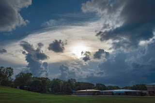
8:48 pm. A waxing gibbous moon is thinly veiled by clouds in the southeast sky. 1/15 second exposure at f/5.6, 200 ISO and 55mm focal length.


9:01 pm. Panorama looking south. 1/6 second exposure at f/3.5, 400 ISO and 18mm focal length.


9:01 pm. Panorama looking SSW. Same settings as image above it. Nikon D7200 DSLR camera.

Read more...

Unexpected Destructive Day

Sunday, July 22, 2018


No one really saw this one coming. SPC forecasters posted only a Slight Risk for the state of Iowa on Thursday, July 19, 2018. Models predicted a better chance for hail or wind for the area, with only a 2 percent chance of tornadoes (above).


So surprise was raised when at 3:10 pm CDT Tornado Watch 285 was posted for central/east central Iowa.


Almost immediately, tornado-warned cells sprang to life and began moving east in central Iowa--lined up from Hardin County in the north to Mahaska County in the south. The IEM radar images above show reflectivity scans from 2:55 pm, 3:30 pm, 4:45 pm and 5:25 pm. Below, GOES16 satellite imagery for 4:40 pm, 4:55 pm and 5:17 pm is shown. The Marshalltown storm is circled.


A much more sophisticated visual of the growing storm is this weatherTAP radar screen image from 3:32 pm. Note the large amount of lightning just east of the Des Moines area, and the "Tail-end Charlie" storm cell. It was soon after this moment that I gathered my photography and communication gear and headed south with the intention of navigating Interstate 380/US Highway 218 south to intercept the "Tail-end Charlie." Driving south through downtown Cedar Rapids I glanced at the tornado-warned radar signatures on radar and began thinking the cell just west of Marshalltown was appearing more and more ominous. A last-minute instinctual decision diverted my objective west toward this storm on US Highway 30.


4:32 pm. I captured this image through the windshield westbound on US Highway 30, about 2 miles east of Highway 21 in western Benton County. It reveals at left the explosive tornadic storm cell as it was approaching Marshalltown, some 35 miles distant. Reflective glare in the image at right shows dashboard items.


4:38 pm. Still westbound on US Highway 30, with the junction of Highway V18 in southeastern Tama County seen in the distance at center-right. I would make a last-second decision to turn here to acquire a relatively safe spotting position away from Marshalltown, where at this moment a powerful tornado was just entering town. The churning clouds in the background of this image are from that storm.


4:40 pm. Arrived at my spotting position, about a half-mile north of US Highway 30 on Highway V18 at 320th Street. Above is a radar screen capture during this time, showing my location (target icon at right), direction and mileage to the tornado (black arrow), and storm movement (white arrows).


4:46 pm. Volatile storm clouds out ahead of the tornado. This image looks northwest from the intersection of Highway V18 and 320th Street. At this moment I received an emergency alert on my iPhone and my weather radio was spewing forth dire warnings such as: "Tornado emergency for Marshalltown. This is a particularly dangerous situation. Expected hazards include an extremely dangerous and potentially deadly tornado."


4:50 pm. Looking north at storm lowering along Highway V18 toward the town of Vining, about 1.3 miles distant.


4:51. Panorama of the storm, stretching from the west sky (left) to the north (right). At least three car occupants stopped to inquire "if the storm was coming here," and a fellow Spotter Network member from Marshalltown texted me asking if I could see a tornado on the ground from my location--(I could not).


4:51 pm. A single panel from the panorama image above it.


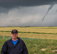
4:53 pm (approximately). A Go Pro Hero 4 Silver "selfie" of yours truly. This is a frame capture from an 18-minute video. The camera was mounted to the interior of my windshield. This wide-angle view looks northwest and shows much of the tornadic cell's structure.


4:53 pm. Looking northwest. Note the very low cloud base in the distance to the right of the barn. I might have been able to see the Marshalltown tornado if not for the many visual obstructions.


4:56 pm. Three-stitch panorama. The storm cell's updraft edge is becoming very defined at left. At this point the tornado was located about 22 miles away.


5:10 pm. The tornado warning for Marshalltown has been lifted, but the tornado warning has shifted east into southern Tama County (I am located in southeastern Tama County). The image above looks southwest at the storm cell's immense updraft (background), and the approaching inflow cloud-like feature in the foreground.


5:18 pm. Mildly rotating lowering approaching from the southwest. The lowering contains an inflow cloud connector at lower left.


5:22 pm. Looking south. Bowl-shaped lowering is sliding to my southeast (left). Heavier rain was beginning to fall at this moment.


Radarscope video frame capture with tornado warnings corresponding to the time for the image above it, and my location at right (target icon).


5:29 pm. Looking south along Highway V18. Probable funnel.


Radar screen capture at the time of the photograph above it, showing my location (target icon), and the arrow pointing to the area of the probable funnel, about 3 miles to the SSE, just east of the town of Chelsea. In about 15 minutes I headed for home. Surprisingly, despite the volatile nature of weather at this location on this day, nothing really met criteria for me communicating a report to the National Weather Service or to other spotters. No hail fell here, wind was minimal and heavy rain only fell later at different locations on my way home. I am of course mindful of the heavy property destruction wrought by three separate tornadoes to the towns of Bondurant (EF2), Pella (EF3), and nearby Marshalltown (EF3). I am thankful no fatalities occurred from all this unexpected weather!


A map showing the 26 tornadoes reported in Iowa on July 19, 2018.


7:50 pm. A striking but benign end of the day: cumulus towers in the northeast sky, as seen from Bowman Woods Park in Cedar Rapids. The clouds were located about 14 miles distant, just northwest of Central City, Iowa. Nikon D7200 DSLR camera.


Read more...

Batteries Not Included

Wednesday, July 18, 2018


My sister and brother-in-law hold an epic bonfire on their property in rural Shueyville, Iowa about twice a year. The bonfire is so large they contact the Shueyville Fire Department beforehand so no outside concern is raised. A gathering for a bonfire on Saturday evening, June 9, 2018 was postponed because of severe weather in the area, so a new date of July 7 was planned. I had great plans for my Nikon D7200 and Tokina 11-16mm f/2.8 lens to capture the event. Though my camera's battery was in no danger of dying, I removed it and placed it into the charger. Fast forward to the bonfire: In ample time before the fire was lit I set up my tripod, and began to prepare the settings for striking long-exposure night photography. Then...no power, no nothing. It was at this moment that I realized the battery was still back home, nice and cozy and powered-up in the charger. A photographer's nightmare! This left me with only my iPhone 6 Plus camera, which of course was a poor substitute for something like this. So...the image above, captured at 9:30 pm CDT, is the best of the set of cell phone camera photographs of the event. Included in the image in the western sky at background right is the -4.08 magnitude planet Venus. This night was definitely a case of: batteries not included--and live and learn!

Read more...

July 15 Venus/Moon Conjunction

Tuesday, July 17, 2018


A first, clouds low in the western sky threatened to obscure the close Venus-crescent moon conjunction show from this Cedar Rapids, Iowa location in Bowman Woods Park on the evening of Sunday, July 15, 2018. Instead, the clouds mixed with the setting sun provided for a beautiful sunset and a good warm-up for the celestial event. This image was captured at 8:38 pm CDT. Official sunset was at 8:40 pm.


By 8:53 pm (above) the clouds had begun to dissipate and the crescent moon and planet Venus revealed themselves brilliantly in open sky. This image looks southwest and is a 1/50 second exposure at f/11, ISO 500 and 55mm focal length.


9:07 pm. In the foreground is Bowman Woods Elementary School. Venus glittered at magnitude -4.12 and was within 2 degrees of the moon. This image is a 1/30 second exposure at f/6.3, 500 ISO and 46mm focal length. Air temperature was 79 degrees. Mosquitos were beginning to bite vigorously, so it was time to retire from the field! Nikon D7200 DSLR camera.

Read more...

Classic Summer Evening Storm

Saturday, July 14, 2018


The summer setup for a storm in eastern Iowa on Friday, July 13, 2018 was a classic one. At 4:30 pm CDT weather conditions in Cedar Rapids were: 93 degree F temperatures, 75 degree dew points, 56% humidity and winds out of the south at 9 mph. Despite a previous dinner engagement for my wife and me to attend at 6:00 pm (which prevented me from spotting out in the field), storm cells were popping up north, south, east and west of the city. One of the cells exhibiting a strong mushroom-like updraft was this one (above), shown at 5:00 pm, looking southeast. It was located about 15 miles distant over Lisbon, in SE Linn County. All images posted today were captured from our back deck.


The same storm cell five minutes later. All cluster of storms were moving ENE. By this time Cedar Rapids was included in a severe thunderstorm warning.


A zoomed in shot of the storm cell at 5:08 pm, showing some of its texture.


Radar frame capture for 5:21 pm, showing my position (target icon), surrounding storms and the severe thunderstorm warning boxes.


5:38 pm. Ominous stormy area in the northeast sky behind treetops in the eastern part of Bowman Woods Park. Minutes later as straight-line winds blew through, leaves from trees fluttered high above after being torn from branches, and some small branches fell to the ground. I estimate wind speeds here reached from 55-60 mph.  Getting to dinner was a wet one! Nikon D7200 DSLR camera.

Read more...

Lakeside Seats for the Cedar Rapids Fireworks

Saturday, July 7, 2018


Our viewing group set up plenty early this year for the annual downtown Cedar Rapids, Iowa Fourth of July fireworks show. This year we selected a location farther away than past years--across Cedar Lake and 1.2 miles from the fireworks' launch point. The wide expanse of water as a foreground element would give us a highly reflective view of the bursts of colorful light. We set up our chairs along the trail that edges the lake, but at 7:33 pm CDT (just over two hours until showtime), Wednesday, July 4, 2018, a small rain shower passed overhead creating the rainbow in the image above--a natural light show. The rain at this time appeared to be falling from a clear blue sky! St. Luke's Hospital can be seen at background right.


9:47 pm. Fireworks show is under way! Looking SSW across Cedar Lake toward the downtown buildings. The -2.28 magnitude planet Jupiter can be seen in the sky at left center. Image is a 3-second exposure at f/7.1, ISO 160, 55mm focal length. Air temperature was a pleasant 82 degrees F.


9:51 pm. Image is a 2-photo stack, each a 4-second exposure at f/7.1, ISO 160, 55mm focal length.


9:52 pm. 8-second exposure at f/7.1, ISO 160, 55mm focal length. Jupiter can be seen in this image as well.


9:53 pm. Image is a 2-photo stack, each a 6-second exposure at f/7.1, ISO 160, 55mm focal length.


9:58 pm. 6-second exposure at f/7.1, ISO 160, 55mm focal length.


10:04 pm. Image is a 3-photo stack. Each photo's exposure ranged from 6-8 seconds at f/7.1, ISO 160, 55mm focal length.


10:05-10:06 pm. Image is a 3-photo stack. Each photo's exposure ranged from 6-10 seconds at f/7.1, ISO 160 and 55mm focal length. Nikon D7200 DSLR camera, AF-S Nikkor 18-55 1:3.5-5.6 lens, Vanguard Alta Pro 263AT tripod.

Read more...

The Hot and Cold of It

Tuesday, July 3, 2018


Heat advisories were issued in Eastern Iowa for two straight days--June 29 and 30, 2018--where a combination of high temperature, dew point and humidity created dangerous situations for many. Looking for an ideal location to capture this photographically, I chose the grounds at Echo Hill Presbyterian Church in north Marion, Iowa, with its abundance of wildflowers and corn fields. Water vapor from the corn was contributing to the sultry conditions seen in the image above, looking west from the north border of the property at 3:44 pm CDT. Air temperature was 93 degrees, dew point 78 degrees and humidity 62%, creating a heat index of 106 degrees. The previous day's heat index topped out at 110 degrees.


I could just feel this cornfield aspirating humidity! The image looks north from the church grounds at 3:46 pm. The elevated view seen here was achieved by setting the camera's timer to a two second delay, pressing the shutter button, then quickly raising the camera-on-tripod as high as I could before it took the picture.


With the hot, many times comes the cold. This College of DuPage GOES16 satellite image shows high cloud tops (circled) at 6:36 pm in Marshall County--storm initiation fed by an approaching cold front.


6:55 pm. I began monitoring the storm's progress as it moved eastward and selected this vantage point in Bowman Woods Park in Cedar Rapids to view it. The anvil of the now-severe storm--located some 65 miles distant near Marshalltown--has nearly obscured the sun. In the foreground is Bowman Woods Elementary School.


Radar frame capture of the event, corresponding to the time of the image above it. My location is marked by the target icon at right, with the arrow pointing to the area of the storm.


7:09 pm. Now in my backyard and looking west over the park. The anvil is so large it required me to shoot a five image panorama to include its entire structure.


8:32 pm. I had in the last half-hour repositioned myself to a new open spotting location on the grounds of Noelridge Christian Church in Cedar Rapids. The cold front churned on. Despite the storm due west of here losing its severe warning, it sported a very impressive shelf cloud which dominated its leading edge. This panoramic image captured the incoming storm when it was about 11 miles distant, near the town of Shellsburg.


Looking northwest at a smaller visual slice of the shelf cloud at the same time.


Radar frame capture of the storm's appearance at nearly the same moment as the photograph above it. Again, my location is shown as a target icon. The arrow points to the leading edge of the gust front.


8:55 pm. The leading edge of the storm has passed through in this image looking southwest. Surprisingly, winds were less than 50 mph here, and lightning and rain were minimal. A much different situation than what the city of Des Moines found themselves in--10 inches of rain in some places--causing massive flash-flooding!


Read more...

  © Blogger template On The Road by Ourblogtemplates.com 2009

Back to TOP