Memorial Day Pop-up Storms

Thursday, May 31, 2018


Returning home to Cedar Rapids, Iowa from Des Moines on Memorial Day afternoon, May 28, 2018, we experienced pop-up thunderstorms--and of unusual variety. All of the small clusters of summer-like storm cells exhibited a northwesterly directional track. Above, an anvil cloud looms before us at 2:53 pm CDT as we enter the eastbound on-ramp for Interstate 235 from 56th Street in Des Moines.


3:06 pm. Skies are darkening to the east as we near the Altoona, Iowa exit on Interstate 80.


3:10 pm. Approaching a rest area on Interstate 80, about 3 miles east of Altoona. We can start to see features on the horizon such as trees and structures begin to dissolve into the approaching heavy rain shaft ahead. This rain shaft would carry pea-to-dime size hail, prompting a severe warning by the National Weather Service in Des Moines.


IEM radar image capture for 3:10 pm, showing the shaded area for Polk County and the accompanying severe warning polygon box.


3:17 pm. Heavy rain and hail slowed traffic to a crawl, and amazingly dropped air temperatures from around 96 degrees F to 66 degrees F--a difference of 30 degrees! Image was captured near Mitchellville, Iowa.


3:24 pm. Looking northeast at rain shaft while eastbound on Interstate 80 near Colfax, Iowa. Again, from the camera's point of view, these storms were moving right-to-left. Nikon D7200 DSLR camera.

Read more...

Round Two of May 25 Storm

Wednesday, May 30, 2018


With the severe warning being lifted in central Iowa just before 8:10 pm CDT, Friday, May 25, 2018, I left the Benton County area of US Highway 30 south of the town of Keystone. Another severe-warned storm was moving SE north and east of Marion, Iowa. Staying on 30 until I reached the northbound option of Highway 13, I encountered a shelf cloud vista (above)--loaded with lightning--at 8:44 pm while being located about a half-mile south of US Highway 151 in Marion. This storm was about 25 miles distant and closing.


Radar screen capture corresponding to the photo image at top--showing my location--with arrows pointing to the leading edges of the shelf cloud.


8:52 pm. Stationary at the WMT AM600 transmitter on Radio Road, about .3-mile east of Highway 13 and northeast of Marion. The approaching shelf cloud is now about 14 miles distant. 1/5-second exposure at f/5.6, ISO 500, 16mm focal length.


8:53 pm. Dramatic section of the shelf cloud, looking east down Radio Road. This section of the storm was located about 20 miles away. 1/5-second exposure at f/5.6, ISO 500, 16mm focal length.


8:56 pm. Also striking was this west-edge section of the shelf cloud, backlit by the setting sun. 0.8-second exposure at f/8, ISO 500 and 16mm focal length.


9:00 pm. Panorama from west-to-east. Leading edge now just about 8 miles distant. The wind was already beginning to pick up and the temperature to drop. Image is a stitch of 6 separate vertical exposures, each 0.8-second at f/8, ISO 500 and 16mm focal length. Nikon D7200 DSLR camera.

Read more...

May 25, 2018 Severe-Warned Central Iowa

Tuesday, May 29, 2018


I wasn't really expecting any severe weather within grasping range from my home in Cedar Rapids, Iowa on Friday afternoon, May 25, 2018. A small storm cell popped up around 3:00pm CDT near LuVerne, Iowa in northern Humboldt County and went unnoticed by me until about 5:00 pm, when it went severe-warned. This storm was moving in a southeasterly direction and over an hour later I made the decision to head toward it. I pulled off US Highway 30 just onto the Benton-Linn Road--just 3.5 miles west of Cedar Rapids--and captured the panoramic image above at 7:14 pm. The panorama creation was necessary to visually include the entire 60-mile stretch of this storm system. The left (southwest) edge of the system was located near the town of Albion, and the right (northeast) near Fairbank.


7:19 pm. Another panoramic image of the storm system. This time I was located at 30th Avenue (Highway 201), just north of US Highway 30 in Benton County. The most intense part of the storm (seen left of the cell tower) was located about 55 miles distant, just east of the town of Liscomb, in northern Marshall County.


7:20 pm. This is a zoomed-in portion of the most intense area of the panoramic image above it. I was a little nervous of this as it sported a near vertical updraft wall and resembled a wedge tornado. Note the now-engulfed sun at top.


This radar screen capture corresponds to the time of the image above it. The (target icon) image at lower right indicates my position, with arrows pointing toward the leading edges of the storm.


Another panorama at 7:20 pm.


7:23 pm CDT. On the move again. Westbound on US Highway 30, about .35-mile east of Highway 287, and about 1.75-mile south of Newhall, Iowa in Benton County. The underside of the storm is exhibiting a wall cloud-like appearance.


7:28 pm. Stationary behind the Youngville Cafe along US Highway 30, and about .1-mile east of 24th Avenue (US Highway 218). This panoramic image shows a small inflow cloud included with the wall cloud-like structure. That area was some 45 miles away, near the Marshalltown, Iowa airport.


7:40 pm. An artistic photographic rendering of the retro-flavored Youngville Cafe, with the storm cloud along US Highway 30 (left) in Benton County, Iowa. Image looks west.


7:47 pm. Looking west from 21st Avenue (County Road V66), just north of US Highway 30, and just under 3 miles south of Van Horne, Iowa.


Panoramic version of the same scene.


8:06 pm. Looking west from US Highway 30, about .4-mile west of County Road V56 and about 3.75 miles southeast of Keystone, Iowa. The sun is beginning to emerge from underneath the storm, whose severe warning would be cancelled in just minutes. At this point I decided to return on US Highway 30 back to Cedar Rapids and Marion, where a new storm was approaching that area from the north. Nikon D7200 DSLR camera.

Read more...

Remembering the May 25, 2008 Iowa Storm

Thursday, May 24, 2018


Ten years ago a powerful storm tragically blew through the northern part of Iowa, leaving in its wake serious destruction and anguish in the towns of Parkersburg and New Hartford. The .7-mile wide EF5 tornado that impacted the communities was responsible for 7 fatalities in Parkersburg and 2 in New Hartford. The radar image above shows Parkersburg (circled) about five minutes after the tornado entered town (5:00 pm CDT, Sunday, May 25, 2008).


By chance, I was on my way back home to Cedar Rapids with friends following a fishing trip in northeast Minnesota when we happened upon the storm. Our route back home took us across its track, though about an hour and a half following the Parkersburg event. Above, the camera looks southeast while eastbound on US Highway 18, about one mile west of Floyd, Iowa at 6:24 pm. A still-potent looking supercell dominates the background.


A minute later, entering the town of Floyd. The most intense area of the storm at this time was about 53 miles distant.


This image was not previously posted and I pulled it from some of my leftover images. Camera looks due south at 6:28 pm along US Highway 218, just south of 185th Street, and about 1.75-mile northwest of Charles City. The storm clouds here were a trailing line from the main system and about 15 miles distant. Parkersburg was actually located another 20 miles behind it.


Radar screen capture corresponding to the image above it. The target icon at left indicates our vehicle's mobile position, with black arrows pointing to Parkersburg, the closer line of clouds, and the most intense area of the storm system. The white arrows show the storm's track.


6:45 pm. Stopped for gas at the Casey's General Store in Nashua, Iowa. Note the wall of clouds in the eastern sky from the retreating storm. Around 5:20 pm, we were told, patrons and employees alike at this convenience store were forced to seek shelter as the sirens sounded. Later we noted sporadic areas of damage along US Highway 20 near Cedar Falls as we continued home. Kodak Z812 Digital camera.

Read more...

Low-light Highlights From May 17

Sunday, May 20, 2018


With ample time to prepare for the crescent moon/Venus conjunction after sunset in Marion, Iowa on the evening of Thursday, May 17, 2018, there were other sky capture opportunities as well. The setting sun creating a blazing vista was one. Above, the sun sets at the tree line near East Robins Road at 8:14 pm CDT, captured as a Aperture Priority setting from a new section of Hampshire Drive in Marion. Official sunset on this day was 8:22 pm.


A zoomed-in 210mm focal length Aperture Priority capture of the same scene a minute later.


Getting into the act in the northwest sky at 8:24 pm was this eastbound jet aircraft and its trailing contrail plume.


8:27 pm. Materializing from the growing darkness but behind a thin veil of clouds was the waxing crescent moon and its conjunction companion, the -3.95 magnitude planet Venus (right).


By 8:48 pm the cloud cover had diminished considerably, allowing the pair to hang majestically over a lighted city landscape with the last fading remnants of the sun's influence still in evidence. Image is a 1/10-second exposure at f/8, 400 ISO and 31mm focal length. Nikon D7200 DSLR camera.

Read more...

Video Screen Captures of May 2 Hills Iowa Tornadic Storm

Monday, May 14, 2018


This image and all the images below are all video screen captures from 7:47-7:52 pm CDT, Wednesday, May 2, 2018, taken from the Casey's General Store in Hills, Iowa and looking northwest. They show the approaching tornadic storm which prompted sirens to sound in the town of Hills. The lower resolution screen captures and growing darkness forced these grainy images, but their dramatic appearance overshadows the noise. Nikon D7200 DSLR camera.


Read more...

Close Encounter of the Jovian Kind

Saturday, May 12, 2018


Okay, 409 million miles is not exactly "close," but it was for the gas giant planet Jupiter in relation to Earth for all of the year 2018 on Thursday, May 10. Jupiter previously reached opposition--being directly opposite of the sun--on May 8. Above, I positioned myself in the Bowman Meadows housing development near Boyson Road and Alburnett Road in Marion, Iowa at 12:22 am on May 10.
The captured image looks southeast, with Jupiter positioned in the center. The planet shone at magnitude -2.51. Light pollution from the city of Marion can be clearly seen at right, enhanced by the five second exposure. Other Nikon 7200 DSLR camera settings for the picture were: f/3.5, 720 ISO, 12mm focal length. A retreating bank of clouds, which delayed the shooting of this image for about 20 minutes, can be seen at background left. Air temperature was 55 degrees F.


A zoomed-in, 300mm focal length capture of the Jovian system (upper right) at 12:05 am, May 10. Image is a 1/10-second exposure at f/5.6, 640 ISO. The moon alignment around Jupiter this night was: Callisto (just left and below), and from right of the planet: Ganymede, Io and Europa.

Read more...

Additional May 2 Hills Iowa Severe Weather Pics

Sunday, May 6, 2018


More of my images captured from the severe weather event in southern Johnson County Iowa during the evening of Wednesday, May 2, 2018. In the image above, I'm southbound on Interstate 380 in south Cedar Rapids, just north of the US Highway 30 exit at 7:09 pm CDT. I'm hoping that I can get south of the approaching storm cell--already tornado warned and approaching fast from eastern Iowa County--without having to cross its path in the process!


7:11 pm. Still southbound near the Eastern Iowa Airport exit (Exit 13) on I-380. Clouds in the distance in front of me are exhibiting a very turbulent and ominous appearance.


7:50 pm. Now at my stop-off spotting position, which was at the Casey's General convenience Store in the town of Hills, located in southern Johnson County. A wall cloud has formed in the west sky. Note the greenish color of the sky at right, denoting the presence of hail.


Same time and again looking west. Wider panoramic image of the view.


Again 7:50 pm. A view of the tornadic lowering in the NW sky. Hail-laden green sky at right background.


7:51 pm. Very pronounced lowering in the west sky. The illuminated area at right is the result off CC lightning. The sirens in Hills would sound in just a couple of minutes. Nikon D7200 DSLR camera.

Read more...

Headed For (the) Hills

Saturday, May 5, 2018


First storm spotting opportunity of 2018. In the morning hours of Wednesday, May 2, 2018, the Storm Prediction Center (SPC) issued its Day One Convective Outlook that that included a severe weather Moderate Risk for the extreme SW part of the state of Iowa and a Slight Risk for most of the eastern (above left). At 3:55 pm CDT, Severe Thunderstorm Watch 63 was issued for the southeastern part of Iowa and all of the northern part of neighboring Illinois (above right). At this point, I began monitoring radar from my home in Cedar Rapids for a possible spotting move.


At around 5:35 pm, a small storm cell began popping up just south of New Sharon, Iowa, in Mahaska County, moving ENE. Twenty minutes later its radar signature was that of the lower left portion of the radar screen capture shown above. At 6:35 pm these line of storms went severe-warned and at 6:50 pm tornado-warned. It was time to head south. But would I get there in time? The nearest intense cell was less than 20 miles west of US Highway 218 in southern Johnson County.


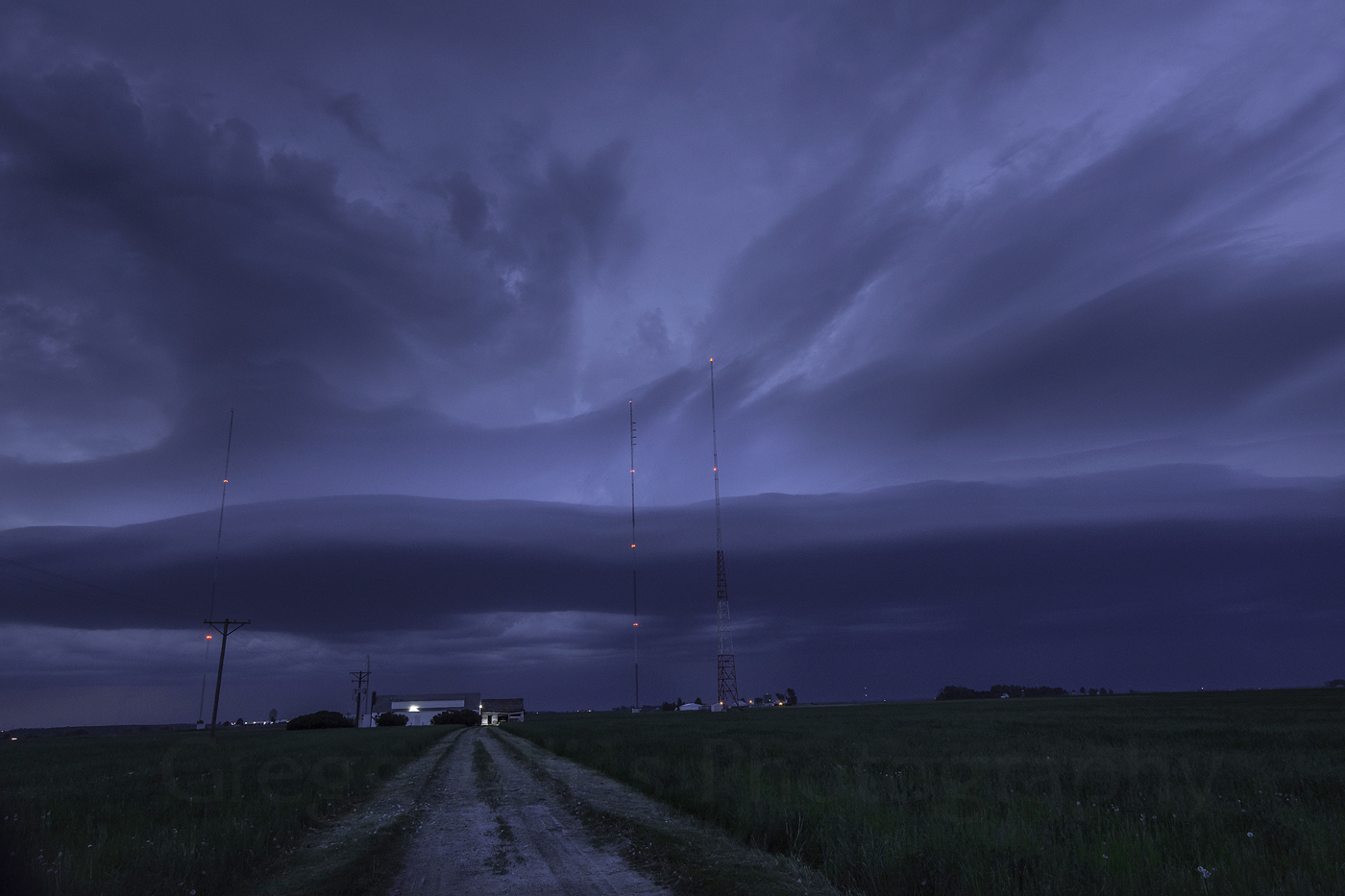
Arrive ahead of it I did. I chose the Hills, Iowa exit and then the parking area of the town's Casey's General Store, with a open view of the west--in perfect position. This image looks west at 7:46 pm and the approaching storm cell already had a tornadic appearance and motion.


7:50 pm. Looking southwest at the southern part of the storm, showing its shelf cloud appearance in that area. From the camera's perspective, the storm was moving from the background to the right of the image. Its forward speed was 20 mph. Temperature was 70 degrees F, dew point 66 degrees, humidity 88%.


Panorama looking west at 7:51 pm. The forming lowering that would pass in front of me in mere minutes is more pronounced now. This is the last sequence of shots I would take outside my vehicle, as CG lightning was becoming more frequent and I no longer had the desire to tempt fate!


7:53 pm. Now a wall cloud in the northwest sky. Taken from my open driver's side window. The adrenaline was beginning to kick in now!


7:53 pm. At this point I was alternating still shots with video from my Nikon D7200 DSLR camera. This image is a video frame capture. Sirens were now wailing in Hills. The ever-tightening tornadic lowering was now about two miles to my northwest, with a hail core about a half-mile farther.


7:55 pm. Video frame capture. Looking very threatening and approaching Oakcrest Hill Road SE (foreground). The lowering passed about two miles to my north. Inflow winds now picked up as did the rain and hail. I estimate at least 60 mph winds buffeted my vehicle, with pea-to-dime size hail falling. Vehicle headlights seen in the distant background are from US Highway 218.


As the lowering passed to my north, driving rain rendered visibility to near zero. Moving at this time would have been foolhardy. Rain and hail were pelting the vehicle so loudly I was barely able to make myself understood to the NWS Davenport severe weather report dispatcher. Above, the interior of my vehicle seen at 8:02 pm, as I waited out the deluge. iPhone 6 Plus image.


Radarscope image capture from 7:46 pm CDT, showing the severe and tornado-warned boxes, and my position in relation to both (blue target symbol) at Hills, Iowa.


Read more...

  © Blogger template On The Road by Ourblogtemplates.com 2009

Back to TOP