Cumulonimbus Cell Forms In Hot Conditions

Friday, August 30, 2013


With temperatures simmering around 97 degrees, this storm cell--sporting a long wispy anvil--was forming in NW Dubuque County, Iowa around 4:08 PM, Friday, August 30, 2013. The camera's perspective was from just east of Faulkner Avenue and Montgomery Circle in northeast Marion, Iowa. The images look northeast. This cell was not severe-warned, but the distant cell (seen at right in the top image) located in the Milwaukee, Wisconsin area was.

Read more...

Heavenly Shades Of Night Are Falling...

Friday, August 23, 2013


Waiting for the "blue moon" to rise in the east on this evening--August 20, 2013--had its fringe benefits. The sunset in the opposite side of the sky was brilliant and beautiful. These views look northwest from the grounds at Echo Hill Presbyterian Church in Marion, Iowa. The top image was captured at 7:36 PM, the bottom at 8:14 PM. Official sunset was at 7:59 PM CDT.

Read more...

Rarer Blue Moon

Wednesday, August 21, 2013


A classic "blue moon" is usually defined as the second full moon to occur in a single calendar month. This one was the other definition, a little more rare than the first. Normally there are three full moons to a season (in this case, summer), but occasionally there are four. The blue moon on this evening was the third of four. These two images look southeast from the grounds at Echo Hill Presbyterian Church in Marion, Iowa on Tuesday, August 20, 2013. The top image of the rising moon was captured at 8:03 PM, the bottom at 8:08 PM. Haze from humid atmospheric conditions made the moon emerge ghost-like from just above the horizon.

Read more...

Fading Glory

Wednesday, August 14, 2013


An illuminated thunderstorm anvil to the west as seen from the interchange of interstates 80 and 380, just west of Iowa City, Iowa. I-80 is seen in the background. This image was captured around 8:17 PM,  Tuesday, August 6, 2013. Less than a half-hour later, the brilliant leading edge turned silhouette.

Read more...

Perseid Peek On Peak

Monday, August 12, 2013


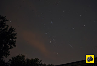
My first sky check at 3:00 AM on Monday, August 12, 2013 was one of disappointment. Skies were overcast on peak frequency night and water was dripping from trees from a recent rainfall. A return to the outdoors one hour later, I witnessed open areas of sky to the northeast--the direction of the Perseids meteor shower. This image, captured at 4:43 AM, was my best of several meteor streaks. The image looks over our roof from our backyard in Cedar Rapids, Iowa and also shows the constellation Taurus (just above and left of the meteor), the star cluster Pleiades (above Taurus) and the 0.06 magnitude star Capella (left, near trees). The brownish smudge to the left is a passing line of clouds (moved right-to-left).

Read more...

The Dark And Light Of It

Sunday, August 11, 2013


Skies were darkening in the top image while at nearly the same time being brightly illuminated by the sun in the middle image on the evening of Tuesday, August 6, 2013 along Sharon Center Road SW (County Road W62) in Johnson County, Iowa. The vantage point was located just south of the intersection of Highway 1, about 2 miles southwest of Iowa City. The top image looks south around 7:46 PM toward a storm cell located about 30 miles away. The middle image, captured at 8:05 PM, shows the setting sun's effect on an anvil cloud. The arrows in the bottom radar image correspond to the direction of each photograph from this spot. Sunset was at 8:18 PM.

Read more...

Hint Of Coming Perseids

Saturday, August 10, 2013


With prospects for a clear sky the next two days leading up to the peak early morning (August 12) of the Perseids meteor shower looking dim due to forecasts for cloudy skies, I took advantage of the cloudless early morning of Saturday, August 10, 2013. This meteor streak was the best of the three I witnessed in about an hour and a half vigil. It was captured from our back deck on Brentwood Drive NE in Cedar Rapids, Iowa looking northeast around 4:27 AM. It is a 15-second exposure at f/1.8, 250 ISO and 35mm focal length.

Read more...

North Liberty Illuminations

Friday, August 9, 2013


The leading edge of a storm cell anvil provided a colorful sky illumination when reflected by the setting sun on the evening of Tuesday, August 6, 2013 in North Liberty, Iowa. The storm was located about 35 miles away when these images were captured, and had fizzled out from previously being severe-warned. The top image, shot at 8:23 PM, includes the water tower near the Kansas Avenue/West Lake Road intersection. The bottom image looks west over the construction site of the University of Iowa Community Credit Union administrative offices building at 2355 Landon Road. Time was 8:30 PM.

Read more...

Pileus Capper

Thursday, August 8, 2013


The wispy hoodlike appearance over this cumulus tower, known as "pileus," was evident around 6:45 PM, Tuesday, August 6, 2013. The camera was located at Bowman Meadows Drive and Archer Drive in Marion, Iowa. The tower, with echo tops around 50,000-55,000 feet, was located about 90 miles to the southwest--in NW Davis County, southwest of Ottumwa (radar image at bottom). Pileus is formed by strong updrafts at lower altitudes acting upon moist air causing the air to cool to its dew point. This storm cell was severe-warned.

Read more...

  © Blogger template On The Road by Ourblogtemplates.com 2009

Back to TOP