Derecho:
A widespread, long-lived, straight-line wind storm that is associated with a fast-moving group of severe thunderstorms known as a mesoscale convective system and potentially rivaling a hurricane and tornadic forces. While we were sleeping, a nondescript storm cell began to form at 10:15 pm CDT, Sunday, August 9, 2020 near the town of Marty, in Charles Mix County, South Dakota, just north of the border with Nebraska. This innocent and for now unnoticed blip would remarkably wreak massive destruction across three states in the coming hours. Above, the radar barely recognizes an area of precipitation as the cell is born (red arrow). The
Storm Prediction Center (SPC) had forecasted a (Day 2) Marginal Risk for Cedar Rapids, Iowa, but this was changed to a Slight Risk during the night.
By 7:16 am CDT, August 10, The SPC had posted an Enhanced Risk (above) for Cedar Rapids, with high probabilities for excessive wind. This now had my full attention.
Severe Thunderstorm Watch 425 is posted by the
National Weather Service/Storm Prediction Center for Central Iowa.
The storm was growing in size and intensifying, and tracking east at around 70 mph. The above graphic shows its August 10 progression at 3:00 am, 8:00 am, 10:00 am and noon, with the most intense areas circled.
10:44 am. The storm was now coalescing into a super-charged severe-warned mass and taking aim at the Des Moines metropolitan area.The intense line stretched from just south of Fort Dodge in the north to just north of Creston in the south. (
Radarscope image).
10:57 am. The SPC posts a Moderate Risk for Cedar Rapids into Northern Illinois, and my heart nearly skipped a beat! Note the very high wind probability outlook at lower right. At this point it was obvious this storm--now classified as a
derecho--meant business and was not going to shed any of its energy along the way. Time to get my spotting gear in place in my car.
11:09 am.
SPC Thunderstorm Outlook, with probable intense areas predicted in far eastern Iowa and northern Illinois.
11:25 am.
Particularly Dangerous Situation (PDS) Severe Thunderstorm Watch 426 is issued for eastern Iowa, northern Illinois, southern Wisconsin and western Indiana.
11:36 am. Activated my
Spotter Network ID on Radarscope in preparation for heading out to my intended spotting location on Quiver Court in Marion, Iowa (42° 2'34.48"N, 91°36'47.94"W), only .8-mile east of my home. Note that the severe thunderstorm warning polygons are now extending two or three counties ahead of the actual storm.
Radarscope frame images for 11:38 am (left) and 11:56 am.
11:53 am. Radarscope image, with my home position in blue at right.
12:08 pm. Now in place at my spotting position on Quiver Court in Marion, Iowa. Sirens began to sound here at 12:18 pm.
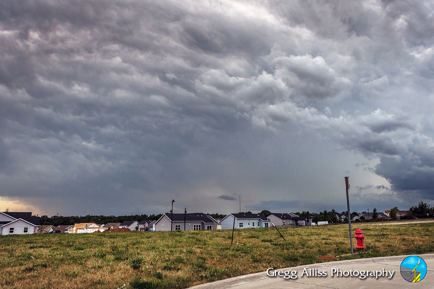
12:22 pm. Looking northwest from my spotting position. Sirens had just ceased sounding, but the sky at the moment looked rather unremarkable. That was about to change.
Spotter Mike Graber (W0WWX) texts me these two pictures taken near Stoney Point Road SW in Cedar Rapids. The left image (12:30 pm) shows the incoming shelf cloud, the right image (12:32 pm) a neighbor's awning and trampoline deposited in his yard from the storm.
12:31 pm. Spotter Billy Gant texts me this ominous west sky shot from 41st Avenue Drive at C Street SW in Cedar Rapids. From my perspective in Marion the sky looks only gray. I glance down to check my radar. When I look up again just a minute later...
12:32 pm. ...this is now how the west sky appears.
12:33 pm. Derecho is approaching fast (about 70 mph), and covering the horizon, as seen in this panorama.
12:35 pm. Similar panorama.
12:36 pm. Now showing a very dangerous appearance, not unlike a high precipitation supercell. The derecho was intensifying as its "bow-echo" apex approached Cedar Rapids.
12:36 pm. Looking west. Storm is immense and only about 7 miles distant, near the town of Fairfax in Linn County.
12:38 pm. Leading edge of the derecho is beginning to overtake my position. Precipitation core at right is evident. Storm is moving right-to-left in image. Image looks SSE.
12:38 pm. Almost here! Rain from the leading edge can be seen just behind the tree line in the background.
12:44 pm. Winds gusting at 60-plus mph in this image looking southeast in the
Bowman Meadows housing development in Marion. The inset picture at right shows a closeup of a swimming pool rolling across the field.
12:52 pm.
GoPro Hero 4 Silver video frame capture looking northwest. I had just repositioned my car to face directly into the wind in order to create the lowest profile. Winds were gusting to 80 mph. I made an amateur radio report at this moment, but this would not continue when I could no longer hear or be heard adequately over the tempest.
12:54 pm. Looking northeast at bending trees through passenger window.
1:05 pm. After a very brief lull, an extended back part of the derecho arrived, packing wind speeds up to 100 mph, as seen in this GoPro video frame capture. I likened this experience to that of being in an automated car wash!
1:05 pm. Looking northeast through the passenger side window at 100 mph winds. My car was rockin'! City power was out and cell service down. Ham radio remained operative. The small unincorporated town of Midway in Linn County recorded a top wind speed of 112 mph!
Winds finally died down enough at 1:30 pm to head out to access damage back home, which was now obviously everywhere the eye could see. My two mag-mounted radio antennas on my car roof were both intact. I turned onto my street from Boyson Road at 1:38 pm and immediately encountered a large fallen tree blocking my way (above).
1:42 pm. Time to try the other access way to my street via Boyson Road and C Avenue NE. Immediate and shocking damage to homes on Boyson Road in
Bowman Woods, one of them seen in this image.
1:45 pm. Southbound on C Avenue NE in an attempt to access Brentwood Drive from the south. Power poles and lines are down in the right lane with smoke in the distance. I had no better luck on Brentwood Drive from the south as a flooded area and more downed trees prevented this. What to do now? How to get back home? I decided to drive back and park in the
Bowman Woods Elementary School parking lot, located just across the park from our house, where I waited in my car for about 35 minutes for the lightning and rain to die down, before walking home.
3:04 pm. One of the many shattered trees encountered as I walked toward home across Bowman Woods Park to drop off some of my equipment--this tree a smaller one.
At about 3:30 pm volunteers cleared the downed tree on Brentwood Drive near Boyson Road and I was able to drive back home. Time to assess damage to our yard. We were fortunate. With no big trees in our yard, our house was undamaged, and our power would be out for only 27 1/2 hours. My roof-mounted weather station survived the gale and recorded a rainfall total of 1.86 inches. I came upon the beach ball in the image above pressed up against our back fence in the aftermath of the storm at 3:42 pm and pondered where it had come from. Des Moines??
Next day and on our way to assist friends on our street with storm cleanup. This image shows colossal damage on Brentwood Drive near Windsor Drive NE on Tuesday morning, August 11, 2020.
Noelridge Christian Church, with significant damage to its west side, is seen on Tuesday afternoon, August 11. The overturned vehicle in the foreground is a small camper.
Wednesday afternoon, August 12. My brother-in-law pushes a large fallen oak tree away from their house with a skid loader. The tree had missed the house by less than a foot!
Family members cutting branches and cleaning the yard.
A
National Crane company crane removes a large tree branch from the roof of a house on Brentwood Drive NE in Cedar Rapids, Iowa on Saturday afternoon, August 15, 2020, five days after the storm.
North view along Brentwood Drive NE on Monday afternoon, August 17, one week after the derecho event. Piles of cut tree branches line the street.
South view. Nikon D7200 DSLR camera.
The derecho blasted a swath of destruction some 600 miles, caused billions in damages and killed four. A virtual "land hurricane." The NWS image above shows the storm's location in one hour increments.
Detailed derecho timeline.
Extreme Meteorologist Reed Timmer doing derecho Live Updates on Monday morning August 10 (top) and after the event (bottom).
Thoughts and prayers to all those who have been impacted by this destructive event--a perhaps once-in-a-century occurrence. We Iowans help one another so well! -Gregg Alliss KE0RBK
Postscript: This
Newsradio 1040 WHO Des Moines article (with wind map above), released on Wednesday, August 19, reports the
National Weather Service Quad Cities (DVN) has determined a peak wind speed of about 130 mph took down an
AM 600 WMT Radio broadcast tower north of Marion, Iowa in the storm. If this were an (Enhanced Fujita tornado rating) it would be a high-end EF2. *** The DVN NWS then added this report at 11:55 am on Wednesday: "Based on the damage to the Westdale Court apartments on the southwest side of Cedar Rapids, which removed the roof, outside walls, and some inside walls from the top floor, National Weather Service damage surveyors estimate that 140 mph winds took place in that location." This would equate to an EF3 tornado rating!
My related YouTube video links:
https://youtu.be/qapgTUwK69w
https://youtu.be/wdXsDSaUQS0
Read more...