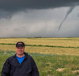
Where has the time gone? A decade has passed since Saturday, April 9, 2011 and the participation in my first "real" storm chase--that is: one where researching a "hot spot" was conducted, driving to a selected and distant location which was at the moment experiencing fair weather, waiting a lengthy period of time for storm initiation, responding to the initiation and following the storm system east, continually staying on its southeast flank. My son Ryan, who had earned his meteorology degree from Iowa State University the previous December, researched severe weather models that Saturday morning to determine if a chase was feasible. By the time the
Storm Prediction Center (SPC) posted the convective outlook shown above (11:21 am CDT), Ryan was convinced of good results for a chase, despite strong capping inversions present in the predicted area of western Iowa. We left Cedar Rapids for Ames, Iowa, where we met up with six of his meteorology student friends for a short strategy session concerning the coming chase. Included in this group were: Nick Carletta, Bryce Link, Ethan Milius, Tristan Morath, Tyler Roney and Sam Schreier. Our selected location to wait out storm initiation was a
Casey's at Minden, Iowa on Interstate 80, and an abandoned former convenience store site just to its north. By 4:55 pm with the cap broken and a supercell already exploding skyward to our west, we were at last underway. The group was now chasing what would turn out to be an epic tornado outbreak in western Iowa, and we would view 5-8 tornadoes before the night was done.
5:50 pm CDT. Storm chasers Bryce Link, Sam Scheier, Nick Coletta, Ryan Alliss and Tristan Morath view the growing supercell from about 3 miles west of the Onawa, Iowa Interstate 29 exit.
6:19 pm. Bloated supercell with mini funnels looking west while northbound on Interstate 29, just south of County Highway E24. (Bryce Link capture with my camera)
6:36 pm. Building supercell looking back south while eastbound on Highway 141, just south of Hornick, Iowa.
7:08 pm. Circulation aloft that would become the Mapleton, Iowa EF3 tornado. This location was just west of Ute, Iowa, and about 8.5 miles southeast of Mapleton.
7:22 pm. Panorama looking north at developing tornado as seen from Sumac Avenue, about 7 miles southeast of Mapleton.
7:24 pm. Looking northwest at EF3 tornado just before it impacted Mapleton. The tornado would destroy 60% of the town.
7:32 pm. Storm chasers Bryce Link, Sam Scheier, Nick Carletta, Ethan Milius, Ryan Alliss, Tyler Roney and Tristan Morath view the EF3 tornado as it leaves the Mapleton area. The location was Sumac Avenue at 170th Street, about 5 miles southeast of town.
8:12 pm. Storm chasers look north in 50-plus mph RFD winds from Keystone Avenue at 330th Street, one mile west of US Highway 59, and about 8 miles south of Ida Grove, Iowa. From left: Tyler Roney, Bryce Link, Ryan Alliss and Gregg Alliss. (Tristan Morath video frame capture)
8:30 pm. Driver Ryan Alliss observes tornado while northbound on County Highway M31, south of Arthur, Iowa. All tornado images from here on were video frame captures, illuminated by lightning.
8:32 pm. Stationary along County Highway M31, looking north, about one mile south of Arthur. Tornado is about 2.5 miles to our northwest, on a northeasterly track.
8:38 pm. Chasers looking north at low rotation from Hope Avenue at Highway 175 (330th Street), two miles east of Odebolt, Iowa. This EF3 tornado was on a northerly track.
8:38 pm. Multi-vortex tornado.
8:56-8:57 pm. Long exposure of a vivid lightning display looking northeast from 255th Street, about one-tenth mile east of US Highway 71 and 2.5 miles southeast of Early, Iowa. Strong RFD winds are blowing the trees in the background. The dark area at left is a supercell with a tornado on the ground at this moment. We were cautioned by a highway patrol trooper here who then sped on up the road at right.
9:10 pm. Too close! EF3 wedge tornado to our northwest as we are northbound on County Highway M50, approaching the center of town at Nemaha, Iowa. The tornado is less than 2 miles distant, and we later determined the strong probability of being in its outer circulation. We made a quick and safe escape east at the center of town.
9:46 pm. Stationary and looking north at supercell as seen from County Road D15 at County Road N33 (leading off into the distance), about 1.5 miles west of Knoke, Iowa. Long exposure image. Red lights in the distance are from a wind farm. High RFD winds made stabilization of the camera image difficult. The day's chase ended here, and we finally rolled back into Cedar Rapids around 1:15 am, April 10--exhausted but safe and exhilarated. Nikon D5000 DSLR images.
Read more...


