Pretty Pillar
Sunday, January 23, 2022


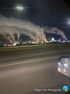
Friday morning, January 21, 2022 in downtown Cedar Rapids, Iowa, and it was C-O-L-L-L-L-D1! The frigid air temperature was -11 degrees F, and it was visually enhancing the steam emissions from the area's business plants. Above, I am southbound on Interstate 380 at 5:29 am CST. The steam at background left is from Ingredion (formerly Penford).
Similar capture at 5:30 am.

The moon shines feebly through the mist of drifting steam emissions from the nearby ADM plant in this view looking southwest from 33rd Avenue at 12th Street SW. Time was 5:40 am. iPhone 11 camera.
Read more...
Snow began to fall in Cedar Rapids from a powerful winter storm approaching from the northwest just after 9:00 am on Friday, January 14, 2022. Forecasts for Central Iowa were in the 10 inch range, but less in the eastern part of the state. Above, I am northbound on Interstate 380 in downtown Cedar Rapids at 10:07 am. Light snow was falling and beginning to stick to the ground. Air temperature was 32 degrees F.

Similar image.

Radarscope frame capture at 10:08 am. The heaviest areas (yellows and greens) were tracking to the southeast.

10:09 am. Continuing northbound on I-380 near St. Luke's Hospital.

10:10 am. Winter storm notice, northbound on I-380 near the H Avenue NE exit. iPhone 11 camera.
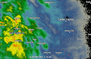
2:40 pm radar screen capture. Storm in central Iowa has intensified, but stays west of Cedar Rapids.

2:57 pm. While snow of medium intensity was falling, I set out on foot for nearby Boyson Park, at the border of Marion, Iowa and Cedar Rapids. Shown above is the old Marion waterworks reservoir located in a field where many of its surrounding trees were ravaged by the August 10, 2020 derecho. Air temperature was 28 degrees F.
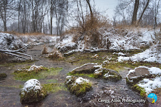
3:02 pm. One of a couple of natural springs in the area that fed the old waterworks. The bubbling of the spring can be seen at bottom right. The springs have helped create this small tributary of nearby Dry Run Creek. Note the lush green grass in the spring water that remains in that state way year-round.

3:02 pm. Similar capture. This spring is located just a couple of yards from the reservoir.

3:04 pm. Looking southeast down Dry Run Creek, located a short distance from the springs. When the storm ended early the next day, a total of four inches fell here. Nikon D7200 DSLR camera.


8:52 am. Sun dog spectacle climbs higher above the horizon. Air temperature was -6 degrees F. iPhone 11 camera.

3:35 pm CST, Thursday, January 6. Looking southwest from Bowman Woods Park in Cedar Rapids. Air temperature was -1 degree F, with winds out of the northwest at 5-10 mph, making for bone-numbing photography fingers!

Panoramic version of the same time setting at 3:35 pm.

3:38 pm. Sun drops lower in the southwestern sky at the park. Nikon D7200 DSLR camera.
Sun dogs flank the Sun within a 22-degree halo and are caused by the refraction or scattering of sunlight through hexagonal ice crystals that are suspended in cold cirrus or cirrostratus clouds high in the atmosphere, or drifting in freezing moist air at low levels as diamond dust. The crystals act as prisms, bending the light rays passing through them with a minimum deflection of 22 degrees. As the crystals gently float downwards with their large hexagonal faces almost horizontal, sunlight is refracted horizontally, and sun dogs are seen to the left and right of the Sun.


Another view of this curiosity, looking northeast at 5:42 am. iPhone 13 camera.

3:43 pm CST, Wednesday, January 5, 2022. High winds were blowing snow and ice crystals aloft, creating sun dogs both in the morning and again in the evening. This image looks southwest from Alburnett Road near Flight Drive in the Bowman Meadows housing development of Marion, Iowa. Air temperature was 12 degrees F, winds were out of the northwest at 10-20 mph.

Similar view at 3:48 pm. Nikon D7200 DSLR camera.

A powerful winter storm started off the new year of 2022 in eastern Iowa in an undoubtably dubious way. Moderate-to-heavy snow with sustained 10-15 mph winds and gusts in the 30 mph range, wreaked havoc with travelers and motorists on January 1. Some intrepid individuals, however, braved the elements on the sledding hill at Bowman Woods Park in Cedar Rapids, Iowa. The above image, captured at 4:06 pm CST, looks directly into the teeth of a NNW wind. In the background is Bowman Woods Elementary School and Boyson Road. As I trudged up the hill (from the right) to get these pictures, I had to stop several times to stand behind trees to catch my breath and to shield myself from the stinging blasts of snow to my face.

Similar capture at 4:07 pm. Note the round snow splotches on the camera lens.

Comparable Radarscope radar image capture for the two images above. The target icon shows my location.

Looking south from the top of the sledding hill during the storm.

The storm caused many cancellations to be issued, including events for the following day. One of them was Noelridge Christian Church at 7111 C Avenue NE in Cedar Rapids, whose deserted and snowy parking lot is shown above at 8:14 am on Sunday, January 2. Air temperature was -8 degrees F.

Similar capture at 8:15 am. The winter storm deposited five inches of snow at my home location. Nikon D7200 DSLR camera.

© Blogger template On The Road by Ourblogtemplates.com 2009
Back to TOP

