Aurora Event on April 23 Was a Blaze of Glory

Wednesday, April 26, 2023


Most of the United States was aware of the good possibility of aurora (Northern Lights) for Sunday, April 23, 2023, as attested by this spaceweather.com email alert the day before (above). "Minor to strong" geomagnetic storms were predicted by the (National Oceanic and Atmospheric Administration (NOAA). States in the midwest were among those listed for possible viewing of the event. As it turned out, the storm was much more intense than previously forecasted.


I began monitoring my Aurora Alerts app frequently as it grew dark on Sunday evening. This intense display (above) prompted me to locate to an area north of the light-polluted metro area of Cedar Rapids, Iowa, and I selected Lowe Park on the northern edge of Marion, Iowa. 


At my selected spot in Lowe Park (42° 4'4.57"N,  91°36'16.06"W) and set up my camera on a tripod looking north. By 9:59 pm CDT (above), the aurora was low on the horizon, but building in brightness. It sported blue pillars in this image, which was a 6 second exposure at f/2.8, ISO 1600, 11mm focal length.


10:03 pm Aurora Alerts polar view. The red area is the most intense activity. Yellow areas are now as far south as northern Kansas.


10:13 pm. The peak days of the Lyrids Meteor Shower were coincidentally occurring during the same time as the aurora's arrival, but this was still a very lucky capture for me! The bright meteor appeared just about a second before this particular exposure ended. 6 second exposure at f/2.8, ISO 2500, 11mm focal length.


10:27 pm Aurora Alerts view. The intense red area has reached south to the Canada/US border.


10:53 pm. Looking north. Aurora growing in brightness, with tendrils extending upward. 4 second exposure at f/2.8, ISO 2000, 11mm focal length. It was about this time I considered heading back home--I had captured my prized meteor pic and the aurora didn't appear to be expanding much. (I'm glad I stayed...)


10:56 pm. The occurrence that stopped me dead in my tracks and kept me from leaving was this solitary well-defined pillar that suddenly formed at center. This signaled the beginning of the intensifying stage of the geomagnetic storm. 4 second exposure at f/2.8, ISO 2000, 11mm focal length.


11:05 pm. Now the "fireworks" were beginning. The aurora's features were brightening and growing higher in the north sky. 4 second exposure at f/2.8, ISO 1600, 11mm focal length.


11:11 pm. Looking NNE. 3 second exposure at f/2.8, ISO 2000, 11mm focal length.


Extended image of the pic above it. At lower left the moon and the planet Venus can be seen. The pillars give the aurora a "crown" appearance in this panorama shot. North is at center.


11:13 pm. Aurora now exhibiting a "twisted ribbon" appearance. 3 second exposure at f/2.8, ISO 2000, 11mm focal length.


11:15 pm. Extended pillars. 2.5 second exposure at f/2.8, ISO 2000, 11mm focal length.


11:16 pm. Similar view. Image looks NNE and is a 2 second exposure at f/2.8, ISO 2500, 11mm focal length.


11:19 pm. Aurora expanding and with pillars reaching skyward. 2 second exposure at f/2.8, ISO 2500, 11mm focal length.


11:20 pm. Similar view. 2 second exposure at f/2.8, ISO 2500, 11mm focal length.


11:25 pm. Aurora now more diffuse, decreasing slightly in intensity, but growing in area. The upper parts had reached the zenith in the sky. Image looks northeast. 2 second exposure at f/2.8, ISO 2500, 11mm focal length. It was at this time I began experiencing the ghostly ripple phenomenon. A faint and very fast moving "ripple" ran horizontally through the illuminated areas, making me think this is how a ripple through time and space must look like. 2 second exposure at f/2.8, ISO 2500, 11mm focal length.


11:29 pm. Looking northeast. Intensity was now ebbing, and this was the last capture I made before returning home. 3 second exposure at f/2.8, ISO 2500, 11mm focal length. Temperature was in the upper 20s F. This event was classified as a G4 "severe" geomagnetic storm. It is reported to have descended all the way south to Mexico. The solar maximum, at which time the sun reaches its highest activity, is due next year. The high/low cycle is in a span of about 11 years. The last time I have witnessed a comparable storm to this one in Cedar Rapids was on November 5, 2001. Nikon D7200 DSLR camera. Tokina AT-X Pro DX 11-16mm f/2.8 aspherical lens. Vanguard Alta Pro 263AT tripod.


11:51 pm. Still packing a punch in this Aurora Alerts polar view.


Read more...

April 4: Round 2 of Severe Weather in Iowa

Saturday, April 15, 2023


Convective outlooks by the Storm Prediction Center (SPC) leading up to April 4, 2023 in the midsection of the US looked eerily similar to the event on March 31 that produced significant tornadoes and was forecasted as a rare High Risk. Moderate Risks were forecasted again in north and south regions (above). Left panel was captured at 5:45 am on April 4, and 12:20 pm for the right panel. Some of the more flamboyant YouTube forecasters even pondered if this event might be more significant than the first. I thought that line of thinking was a long shot.


9:12 am CDT, Tuesday, April 4, 2023. National Weather Service Quad Cities Warning Coordination Meteorologist Rich Kinney for the second time in five days emails out a heads-up notification for storm spotters.


11:30 am. SPC Convective Outlooks--Categorical, tornado, hail and wind.


3:45 pm. SPC posts Mesoscale Discussion 456, predicting the likelihood of a tornado watch for southern and eastern Iowa at 95%.


3:49 pm. My home Tempest Weatherflow weather station showing east winds, with a temperature of 56.5 degrees F--fairly cool--but with 53 degree dew points.


3:50 pm. Satellite image. Sunny in the southwest part of Iowa, with cumulus clouds beginning to bubble up in the unstable atmosphere. 


4:55 pm. Storm near Des Moines growing and casting a shadow in this satellite image. 


5:01 pm. By now storms are erupting in western Iowa, and also entering southeast Iowa, but with a conspicuous storm-free area around Cedar Rapids. (Note all the activated Spotter Network icons on this WeatherTap radar map). Because there was nothing threatening the areas around Cedar Rapids, I remained at home with only about two and a half hours of light remaining, waiting to make a decision.


5:08 pm. Tornado Watch 115 is issued, valid until 10:00 pm.


5:48 pm. WeatherTap radar map showing my location in Cedar Rapids, with storms still at either side of my area. The red on the map indicates the Moderate Risk. It was time to make a decision to pick a storm to intercept, and I quickly chose the southern storm to the southwest, currently in Ringgold County. My plan was to drive to the Van Horn car dealership on US Highway 30 near Newhall, Iowa in Benton County and wait for it to arrive.


6:58 pm. At the Van Horn car dealership. Radarscope image of tornado-warned cell with a hefty hail core. This storm was to my southwest and tracking in my direction. 


7:24 pm. At Van Horn car dealership. Only 11 minutes until sunset. Image looks southwest. Churning mammatus clouds above. The tornado warned cell was about 55 miles distant, just east of Grinnell.


7:25 pm. Looking southwest. The lighter colored tornado-warned storm can be seen through a gap in the darker foreground clouds.


7:29 pm. Similar view with my spotting vehicle in the foreground. Mammatus clouds hang over the tornado-warned storm along the horizon, now located about 50 miles distant.


7:47 pm. Already past sunset and getting darker. I now had to make a decision to stay here or head back toward home. Spotting solo in the dark is inherently dangerous. The approaching storm cell to my southwest was still tornado warned and packing a strong hail core. I decided to leave before it impacted me. Like my decision to leave Hills, Iowa five days earlier, this proved to be the prudent choice. One and a half inch hail fell here after I left.


My new spotting location was Noelridge Christian Church in Cedar Rapids, about a mile from home. The former tornado warned cell, now downgraded to a severe thunderstorm warning, was tracking northeast and passing my location to the west, as seen in these Radarscope reflectivity and velocity images from 8:20 pm.


The storm cell was alive with lightning discharges. This is a stacked image of four shots, all 8 second exposures at f/3.5, ISO 250, and 18mm focal length, seen from 8:37-8:43 pm. Looks west from Noelridge Christian Church. Storm is about 17 miles distant.


8:48 pm Radarscope image. Severe-warned storm cell is tracking northeast and passing to my west. My location is the blue target icon.


8:54 pm. Lightning flashes looking northwest. 8 second exposure at f/3.5, ISO 250, 18mm focal length. Storm was located just east of Vinton, Iowa, in Benton County.


9:00 pm. Looking NNW at the departing storm. Unusual feature is backlit by lightning from this 20 second exposure at f/5.6, ISO 160, 18mm focal length.


9:02 pm. Similar capture. In short order with the storm having passed and the danger being minimized, I excused myself from the amateur radio net I was checked into and headed home. A "capping" layer in the atmosphere inhibited much of the tornado potential on this day in Iowa. It could have been worse than it was, and it was nowhere near what March 31 produced. Nikon D7200 DSLR camera.


Read more...

Rare SPC High Risk Day Impacts Johnson County Iowa With Tornadoes

Saturday, April 8, 2023


This predicted upcoming storm system on the last day of March, 2023 was not going to be an ordinary one. This was evidenced by the NWS Storm Prediction Center's posting of an Enhanced Risk (Level 3, above), four days in advance on Tuesday, March 28. The area included large areas of Arkansas, Missouri, Illinois and my home, Eastern Iowa.


5:00 pm CDT, Wednesday, March 29. Forecasted Enhanced areas expanded.


7:00 am CDT on Thursday, March 30, the day before the event. The categorical outlook has been upgraded to a Moderate Risk (Level 4), and shows ominous areas for tornadoes, hail and wind. Pivotal Weather Graphic.


7:00 am CDT, Friday, March 31--day of the event. All areas have been expanded and energized.


9:05 am CDT. Email from NWS Quad Cities (DVN) Weather Forecast Office goes out to all area severe weather spotters from Warning Coordination Meteorologist Rich Kinney for an awareness "heads up."


11:00 am WeatherTap screen capture showing the dark red area of the Moderate Risk with numerous spotters located throughout, including myself.


11:00 am. SPC Mesoscale Discussion 390 goes out, with the expectation of a "Upgrade to tornado-driven High Risk (Level 5) to be issued at (11:30 am CDT)." 


High Risk (Level 5 of 5) is quickly issued, which includes portions of eastern Iowa and western Illinois. The Moderate Risk area is also expanded.


11:12 am. Screen capture of my home Tempest Weatherflow weather station, showing dew points approaching 60 degrees, falling barometer and strong southeast winds. 


11:16 am. SPC Mesoscale Discussion 393 for a PDS (Particularly Dangerous Situation) Tornado Watch likely to be issued in the next one to two hours. Areas included eastern Iowa, western Illinois and northern Missouri.


11:25 am. Satellite image showing large areas in Iowa of ample sunlight, creating atmospheric instability.


11:35 am. SPC four panel outlook, showing an area of High Risk now included in portions of Arkansas, Tennessee and Mississippi in the South.


11:41 am. Pivotal Weather High Risk map.


11:48 am. WeatherTap screen capture, showing the recent High Risk upgrade area (lavender). 


11:49 am. NWS Forecast Discussion.


11:57 am. PDS Tornado Watch 93 is issued for a large portion of Iowa, northern half of Missouri and western half of Illinois.


11:57 am. Seriously worded and colored issuance of forecasted "Major Severe Weather Outbreak Today and/or Tonight." Now I was in spotting interception mode. But where? The best bet was south of Cedar Rapids, deeper into the High Risk "danger zone." Going solo today, I did not think it prudent to travel too far in these conditions, so my initial thought was setting up spotting operations in the relatively nearby town of North Liberty in Johnson County. I departed Cedar Rapids around 12:10 pm CDT.


En route to North Liberty I of course changed my mind. The small town of Hills, just south of Iowa City had served me well in the past, with a wall cloud sighting on one occasion and a nearby tornado on another. Above, I approach the Hills, Iowa exit on US Highway 218 at 12:51 pm. The unstable atmosphere is evident with churning clouds seen to my south.


At my stationary spotting location at the Animal Haven Veterinary Hospital parking lot in Hills. I first asked permission from the proprietors to locate there. I had originally parked at the Casey's Convenience Store next door, but changed my mind. My vehicle mobile weather station is shown here at 1:16 pm, showing robust southeast winds, temperature of 69 degrees F, and a dew point of 60 degrees.


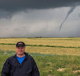
1:20 pm. Yours truly in a serious "selfie" pose from my spotting location at the veterinary hospital on Oak Crest Hill Drive SE in Hills, Iowa.


2:39 pm. Mobile weather station monitor, now showing 72 degrees F temperature and 64 degrees dew point.


2:51 pm. Gathering dark clouds to my southwest.


3:37 pm. Approaching supercell with mammatus on the leading edge of its anvil. The tornado from this storm impacted the town of Keota.


3:38 pm. Velocity radar capture showing rotation (left) and my location (lower right).


3:40 pm. West-looking vista of mammatus clouds, with US Highway 218 in the background. Note the inflow cloud feeding into the storm at lower right.


3:46 pm. Looking northeast at mammatus cloud formations. Many of the structures seen in this image would be severely damaged by the arrival of another tornado, about one hour and 15 minutes later.


3:57 pm. Radarscope frame capture showing tornado-warned cell at left center, and my spotting location in Hills, Iowa.


4:07 pm. Radarscope frame capture. The storm has tracked farther northeast and is about to impact the town of Keota.


4:07 pm. Left edge of an EF4 wedge tornado, located about 30 miles distant, near the town of Keota along the Keokuk and Washington county line. This image looks southwest.


4:12 pm. Tornado is tracking closer to me now from the southwest. The lighter clouds seen among the dark mass of the tornado are rotating around it (from left-to-right in image).


4:12 pm. Similar image. Inflow cloud can be seen low along the horizon at left.


4:13 pm. Radarscope frame capture. The second storm cell (toward bottom) was severe-warned at this time but would eventually become the culprit that would spawn the EF2 tornado that struck Hills.


4:16 pm. Tornado panorama looking west.


4:16 pm. Inflow cloud feeding into the tornado (left center).


4:17 pm. Looking west at the tornado. By this time I had communicated its presence to the Linn County ARES Net via amateur radio, and verbally to the employees of the veterinary hospital where I was located.


4:22 pm. Radarscope frame capture.


4:27 pm. Tornado emerges from behind the line of foreground trees. I had to run across the road and along a fence toward the right (north) to obtain a better visual to confirm for spotting. The tornado was now a lower EF2 rating.


4:31 pm. Radar capture.


4:32 pm. Radar captures.


4:36 pm. Tornado panorama looking west.


4:37 pm. Layered convective clouds looking south. The Casey's convenience store is in the background. It was from this direction--and a bit toward the right--the second tornado would form and strike this very spot.


4:37 pm. Cell phone Emergency Alert.


4:39 pm. Looking east over the roof of the Animal Haven Veterinary Hospital at picturesque swirling clouds. It was around this time I made the decision that probably kept me from serious harm: I had my pictures and video (please see my 10 minute YouTube spotting operations video), so I wanted to head back north, partly to get closer to home, and partly to be able to continue to image the tornado to my west/northwest as I ran "parallel" to it. What I wouldn't know until I returned home was that this very location became heavily damaged by the second tornado, which hit about 15-20 minutes after I left. Was it a God thing that I made this decision?


4:43 pm. Heading back north on US Highway 218, just north of Hills. Tornado is at left, with elongated inflow cloud at right. But all was not well yet: What I absentmindedly disregarded was the fact that the highway direction south of Iowa City travels to the north/northwest, and the tornado was tracking to the northeast. This meant that at some point I would cross the storm's path. Nikon D7200 DSLR camera.


4:48-4:49 pm radar captures.


4:56 pm radar capture. Around 4:55 pm I had reached Coralville Lake on Interstate 380 when high winds and blinding rain swirled over the pavement in front of me. Estimated quarter size hail hit my vehicle and I began to notice random leaves fluttering down from high in the sky. I'm guessing I was inside RFD winds or possibly the outer circulation of a nearby tornado. Thankfully, I emerged from this area unscathed. 


4:56 pm. Tornado-warned areas stretching from Mt. Pleasant in the south to Waverly in the north.


Comparison images of structures just north of the veterinary hospital in Hills, looking north/northeast. Top image at 3:46 pm, about one hour and 15 minutes before tornado struck; bottom image (courtesy of KGAN TV2) in the immediate aftermath of the storm.


NWS service Overview of Tornado Outbreak and Surface Analysis map.


Tornado track maps for Eastern Iowa (left) and the Iowa City area. As of this posting, over 20 tornadoes touched down in the state of Iowa on this rare High Risk day. The towns of Hills, Coralville and Solon, all in Johnson County, reported significant storm damage.


Read more...

  © Blogger template On The Road by Ourblogtemplates.com 2009

Back to TOP