Saturday Sledding Fun

Sunday, January 29, 2023


18 degree F temperatures with falling snow did not deter sledders from having fun on the Bowman Woods Park hill in Cedar Rapids, Iowa on Saturday afternoon, January 28, 2023. The sledders are seen from the bottom of the hill (top image), and from the top of the hill (below). Nikon D7200 DSLR camera.


Read more...

Green (But Lean) Comet

Friday, January 27, 2023


Skies in the Cedar Rapids, Iowa metro area finally cleared on the evening of Thursday, January 26, 2023 after over a week of being clouded over. This provided an opportunity to view the Comet C/2022 E3 (ZTF), which is green in color. This is not a good naked eye viewing opportunity, at least not yet. Instead, it requires a telescope, a pair of binoculars, or in this case a camera long exposure to see it. The comet's apparent magnitude was 5.71, only slighter brighter than magnitude 6.5, the limit the human eye can discern in dark skies. The image above is a panoramic stitch made from five separate exposures, each a 15 second exposure at f/1.8, ISO 100, 35mm focal length. It looks north at 7:50 pm CST along North Marion Road at White Road, about 1.5-mile north of County Home Road, and about 2.5 miles north of Marion, Iowa.


Identical image, with an arrow to show the position of the comet.


Cropped version of one of the five exposures, better showing the comet.


Looking northwest at a farm field post from North Marion Road and White Road at 7:53 pm, with same exposure values as the comet images. Air temperature was 11 degrees F. Nikon D7200 DSLR camera.

Read more...

Snowfall After Historic Tornado Event

Saturday, January 21, 2023


Eastern Iowa experienced its second ever tornado event in the month of January on January 16, 2023. The only other occurrence was on January 24, 1967, when 13 tornadoes touched down in the southeastern part of the state. The aftermath of both events were similar but also a bit different. Within two days of the 1967 storm, heavy snowfall and blizzard conditions dropped up to 13 inches in far eastern Iowa, and two feet further east into the Chicago area. 2023 saw a similar pattern, but with less accumulation. Shell Rock Iowa received the most with about 8 inches, with Cedar Rapids receiving much less at 1.8 inches. The following group of images were captured from Boyson Park, at the border with Cedar Rapids and Marion on Thursday afternoon, January 19, 2023. Above is a water level view of Dry Run Creek, with surrounding vegetation flocked with wet, sticky snow.


A natural spring (bottom) bubbles forth and feeds a tributary of Dry Run Creek. The warm water here keeps fringe grass green all year long.


Similar view of the natural spring area.


Deer graze near the edge of Boyson Park as seen from a nearby trail.


Footbridge over Dry Run Creek. Air temperature was 32 degrees F. Nikon D7200 DSLR camera.

Read more...

Iowa January Tornadoes? Only Once Before.

Thursday, January 19, 2023


Only once before in Iowa's history during the month of January has there been an occurrence of tornadoes, and that was on January 24, 1967 (above). At left a tornado touches down about four miles west of Wapello, Iowa, one of the 13 that occurred that day. The map at right shows positions and tracks of tornadoes in Iowa, Missouri and Illinois. (See my archived posting from January 25, 2011 for a more extensive personal story of that particular event as the system moved east). 


Radarscope frame captures for 9:28 and 9:44 am CST,  Monday, January 16, 2023. A small cell began to form and moved northeast through Cedar Rapids, Iowa and included the rumble of thunder, a very unexpected development! This was to be but a small hint of weather conditions to come.


My home weather station (Tempest Weatherflow) in Cedar Rapids at 9:49 am showing very un-January like conditions.


Weather station data at 11:33 am, now showing 45 degrees F temperatures and 42 degree dew points.


College of DuPage (COD) water vapor satellite images for 12:15 pm (left) and 2:00 pm (right). Note the prominent area at right that was tornado-warned.


There was no reason to believe something like an Iowa tornado in the month of January would ever happen again, even when this Storm Prediction Center (SPC) Convection Outlook was posted at 1:43 pm on Monday, January 16, 2023. It posted a 2% chance of tornadoes in the shaded area. Even a 2% chance in January was highly unusual. 


IEM mesonet surface plot for 2:00 pm CST on January 16, about the time a tornado touched down near Williamsburg, Iowa (yellow circle).


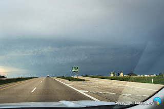
2:16 pm. After having left work shortly after 2:00 pm when a tornado warning was broadcast, I am northbound here on Interstate 380 near St. Luke's Hospital. Visible just above the horizon is an inflow cloud feeding into the storm (toward the left).


2:18 pm. Radarscope frame capture, showing the tornado-warned area (red polygon) as it has moved northeast from Williamsburg. The storm was moving in the direction of Cedar Rapids.


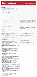
Emailed AccuWeather tornado warning notification for 2:20 pm.


Data from my home weather station at 2:25 pm, showing an abnormally high temperature (47 degrees F), humidity (92%) and dew point (44 degrees).


Radarscope image for 2:27 pm at my stationary spotting position at the Cedar Rapids Family Dental Center (42° 0'34.32"N,  91°39'49.18"W) in Cedar Rapids, Iowa. My position is shown within the tornado-warned area as the target icon.


2:32 pm. A view of my spotting vehicle's thermometer, showing a balmy 48 degrees F.


Radarscope images for 2:39 pm (left) and 2:42 pm (right), now showing an extended tornado warning to the northeast in the second image. 


2:43 pm. Looking southeast at approaching clouds, which are churning and swirling. The Emergency Alert System tone was sounding on my cell phone and sirens were blaring at this moment.


2:47 pm. Looking south. At center is a thin funnel than formed seconds earlier and dissipated seconds later. 


2:49 pm. Looking southeast. Rising motion with funnel.


2:50. Tornadic clouds looking southeast. A very vigorous rising motion was occurring behind the building in the background.


2:52 pm. Looking south.


2:52 pm. Tornadic clouds looking southeast.


2:55 pm. Departing clouds looking northeast.


2:56 pm. Similar view.


2:59 pm. My spotting vehicle, looking south. The most intense part of this tornado-warned storm moved south and east of my position. iPhone 11 camera.


January 16, 2023 now joined January 24, 1967 as dates in which tornadoes have occurred in Iowa during this month. Two tornadoes touched down on this day: an EF1 wedge tornado touched down near Williamsburg in Iowa County (seen in the Vince Waelti video from Interstate 80 above), and an EFU touchdown near Ely, Iowa in Linn County. An early and remarkable start for the 2023 severe weather season!


Tornado Event Summary for January 16, 2023, compiled by the National Weather Service (NWS) in the Quad Cities.


Read more...

In The Misty Moonlight

Saturday, January 7, 2023


A thin veil of clouds began covering the moon, one day removed from being full, as it set in the western sky as seen from Bowman Woods Park in Cedar Rapids, Iowa on Saturday morning, January 7, 2023. The image above was captured at 6:44 am CST, and is a 4 second exposure at f/7.1, ISO 160, 55mm focal length.


Cropped version of the image above it. Air temperature was 8 degrees F. In less than two hours, the sky completely clouded over. Nikon D7200 DSLR camera.

Read more...

Best of 2022 In Review

Wednesday, January 4, 2023


The following images were favorites of mine taken during the 2022 year. Unfortunately I didn't encounter a confirmed tornado, but there were still many sky and weather captures that stood out. The 16 images are listed here in chronological order. Image number 1 (above) shows intrepid sledders in a stinging blizzard at Bowman Woods Park in Cedar Rapids, Iowa on January 1, 2022.


#2. Sun dog panorama as seen from Bowman Woods Park in Cedar Rapids, Iowa on January 6, 2022. Air temperature was -1 degree F.


#3. Brilliant sunset on Brentwood Drive NE in Cedar Rapids, Iowa on March 3, 2022.


#4. Severe-warned storm cell as seen from US Highway 151 near Dodgeville, Wisconsin on May 13, 2022.


#5. Maturing supercell seen from US Highway 61 near Kieler, Wisconsin on June 15, 2022.


#6. Tornado-warned cell as seen from Blue River Road in Iowa County, Wisconsin on June 15, 2022.


#7. Brilliant sunrise from Marion, Iowa on June 17, 2022.


#8. Rare crepuscular arch stretching from west (left) to east (right) emanating from a severe-warned cell near  Cedar Rapids, Iowa on June 28, 2022. 


#9. Approaching shelf cloud panorama as seen from Cedar Rapids, Iowa on July 5, 2022.


#10. Storm cell with crepuscular arch as seen from Cedar Rapids, Iowa on August 3, 2022.


#11. Western wildfire enhanced sunset as seen from Marion, Iowa on September 8, 2022.


#12. Rising Hunter's Moon as seen from North Marion Road north of Marion, Iowa on October 10, 2022.


#13. Full lunar eclipse in the western sky as seen from Radio Road, northeast of Marion, Iowa on November 8, 2022. This was the second of two full lunar eclipses occurring during the year, the other one on May 15-16.


#14. Moon/Mars occultation sequence from Cedar Rapids, Iowa on December 7, 2022.


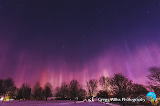
#15. Brilliant light pillars seen from Bowman Woods Park in Cedar Rapids, Iowa during the early morning hours of December 18, 2022. Air temperature was 9 degrees F.


#16. Christmas Eve planetary alignment shortly after sunset as seen from Cedar Rapids, Iowa on December 24, 2022.


Read more...

  © Blogger template On The Road by Ourblogtemplates.com 2009

Back to TOP