
Potent Winter Storm Less in Eastern Iowa
Saturday, January 15, 2022

Snow began to fall in Cedar Rapids from a powerful winter storm approaching from the northwest just after 9:00 am on Friday, January 14, 2022. Forecasts for Central Iowa were in the 10 inch range, but less in the eastern part of the state. Above, I am northbound on Interstate 380 in downtown Cedar Rapids at 10:07 am. Light snow was falling and beginning to stick to the ground. Air temperature was 32 degrees F.

Similar image.

Radarscope frame capture at 10:08 am. The heaviest areas (yellows and greens) were tracking to the southeast.

10:09 am. Continuing northbound on I-380 near St. Luke's Hospital.

10:10 am. Winter storm notice, northbound on I-380 near the H Avenue NE exit. iPhone 11 camera.
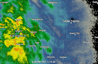
2:40 pm radar screen capture. Storm in central Iowa has intensified, but stays west of Cedar Rapids.

2:57 pm. While snow of medium intensity was falling, I set out on foot for nearby Boyson Park, at the border of Marion, Iowa and Cedar Rapids. Shown above is the old Marion waterworks reservoir located in a field where many of its surrounding trees were ravaged by the August 10, 2020 derecho. Air temperature was 28 degrees F.
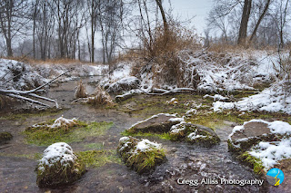
3:02 pm. One of a couple of natural springs in the area that fed the old waterworks. The bubbling of the spring can be seen at bottom right. The springs have helped create this small tributary of nearby Dry Run Creek. Note the lush green grass in the spring water that remains in that state way year-round.

3:02 pm. Similar capture. This spring is located just a couple of yards from the reservoir.

3:04 pm. Looking southeast down Dry Run Creek, located a short distance from the springs. When the storm ended early the next day, a total of four inches fell here. Nikon D7200 DSLR camera.


0 comments:
Post a Comment