Double Shelved
Thursday, July 16, 2020
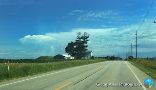
The weather on Saturday, July 11, 2020 was rare in that two shelf cloud/gust front events occurred in the same areas of Eastern Iowa on the same day--one in the morning, and one in the evening. I was a little caught off guard by the morning event. My wife and I were invited to a friend's acreage near Robins, Iowa to pick gooseberries on their property, and I was unfortunately unprepared for the coming storm with only with my cell phone with me. In the image above, we are northbound on Council Street about .75-mile south of East Main Street near Robins at 9:11 am CDT, en route to our destination. The most intense area of the severe-warned storm (left) was located about 52 miles distant, near Readlyn, Iowa in Bremer County.
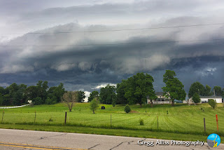
9:14 am. Westbound on West Main Street in Robins at Quass Road and nearing our berry picking destination. Image looks north toward the storm.
10:19 am. Berries mostly picked, and just in time. Above, an incoming and impressively striated shelf cloud approaches from the north. The severe-warned gust front was about 12 miles away. Image captured from Stamy Road and West Main Street in Robins.
Radar frame capture corresponding to 10:20 am, with my location shown by the target icon. Black arrows indicate storm movement. Note the lavender hail core.
10:20 am. Looking northeast at shelf cloud from Stamy Road at West Main Street. This part of the storm was some 11 miles distant, just west of Central City, Iowa.
10:20 am. Panorama capture looking north.
10:21 am. Storm has now closed to about 10 miles distant. Looking north from West Main Street.
10:21 am. Looking northwest. Underside of shelf cloud is very turbulent in appearance.
10:22 am. Panorama of gust front, drawing ever closer at about 8 miles. With the wind picking up and the temperatures falling, I began slowly backpedalling closer to our car. Image looks north from Stamy Road near West Main Street.
10:23 am. Last look at the storm (toward the northeast), before about-facing and hustling to the car. This very impressive looking storm event produced some high winds and rain in the area, but not nearly as much as a second gust front which would occur later in the day. iPhone 6 Plus camera.
10:49 am. Back home. This view of the sky looks east at the trailing end of the departing storm.
Storm Prediction Center (SPC) Convective Outlook, posted at 2:50 pm CDT, with a large area of the state of Iowa in a Slight Risk category for severe weather.
4:00 pm. At my spotting location on Quiver Court, just south of Boyson Road and just west of Alburnett Road in Marion, Iowa, with storms approaching yet again. This image looks northwest at gathering storm clouds. The most intense area of the severe-warned storm cell was located about 40 miles distant, near the town of Traer, Iowa, in Tama County.
4:01 pm. Panorama looking northwest.
4:20 pm. Panorama looking northwest. The most intense area of the storm was located about 32 miles away, near the town of Dysart, Iowa in Tama County.
Radarscope image for 4:38 pm, showing my position at right.
5:44 pm. Edge of incoming severe-warned gust front was about 10 miles to the northwest, near Center Point in Linn County. Storm was now forming a shelf cloud appearance, but not nearly as impressive looking as the earlier morning event.
Radar capture corresponding to 5:45 pm. My spotting location is indicated by the target icon, with storm movement shown by the arrows.
5:47 pm. Panorama of the shelf cloud, now just 8 miles distant and near the town of Toddville, Iowa in Linn County.
5:47 pm. Closeup of leading edge of gust front looking north. It was now time to hunker down inside my vehicle and wait out the brunt of the storm. I estimate wind speeds peaked around 70 mph here (it actually rolled my parked car about a quarter-tire turn backward twice). This was a much more powerful wind event than the storm from earlier in the day. Several spotters in the area reported some large trees down. Nikon D7200 DSLR camera.
Radarscope image for 5:51 pm, showing a new (radar indicated) tornado warning east of my location.


0 comments:
Post a Comment