Eastern Iowa Finally Gets Severe Weather, Cedar Rapids Dodges the Bullet Again

Friday, June 13, 2025


The Storm Prediction Center (SPC) upgraded a Marginal Risk for the northern region of the state of Iowa to a Slight Risk at 11:40 am CDT on Wednesday, June 11, 2025 (above). The new upgrade was mainly for high wind and hail.


2:55 pm. The National Weather Service (NWS) issues Severe Thunderstorm Watch 408 for basically the same area, as seen in this Radarscope image.


During the 5 o'clock hour, storms were firing up and moving into eastern Iowa from the central part of the state. Time to intercept from home base in Cedar Rapids. I selected Interstate 380 as a faster and more direct route to the severe-warned storms. The image above looks northwest at 7:08 pm at a line of advancing storms from a location just under 7 miles southeast of the Gilbertville, Iowa exit.


Radarscope image corresponding to the photo above it, showing the severe-warned polygons.


7:13 pm. On the road again and looking northwest toward the storms about 1.5 miles southeast of the Gilbertville exit in Black Hawk County. The storm is about 23 miles distant, near the town of Dike in Grundy County.


Radarscope image for 7:18 pm. My mobile position is indicated by the blue target icon.


7:19 pm. I had taken the US Highway 20 exit from I-380 (Dubuque) and exited again a half-mile later on to South Canfield Road (north toward Dunkerton), and instantly winds gusted from 50-60 mph (above). Dust and dirt swirled over the highway, trees bended and my vehicle was buffeted.  Another severe-warned storm cell with a hail core was directly ahead, about 10 miles distant.


7:21 pm Radarscope image. Note the continuous forming line of storms to my west and southwest.


7:22 pm. Brief stationary position from Young Road (foreground) and South Canfield Road, about a half-mile north of US Highway 20. 


7:22 pm. Looking northeast. This is the northern cell that contained the pronounced hail core.


7:24 pm Radarscope image. Decision time. I was receiving numerous storm alert notifications, so I quickly decided to head back the way I had come, and out of harm's way.


7:33 pm. Westbound on US Highway 20 back toward the exit for I-380 (background) and southeast to safety. For this very short time I was "playing chicken" with the approaching storms. I also received a notification of hail in the area at this time, making my escape all the more urgent.


The southeast direction of I-380 made it possible to put more separation between me and the line of storms. I was able to arrive at my next spotting location (above) at the BP gas station at the Toddville exit in Linn County with plenty of time to spare. This image, captured at 8:08 pm, looks west, with the southern-most edge of the severe-warned storms seen at left. The storm was about 22 miles distant. 


8:14 pm Radarscope image. This image shows how much storm separation I had achieved in the south, compared to being almost overrun in the north.


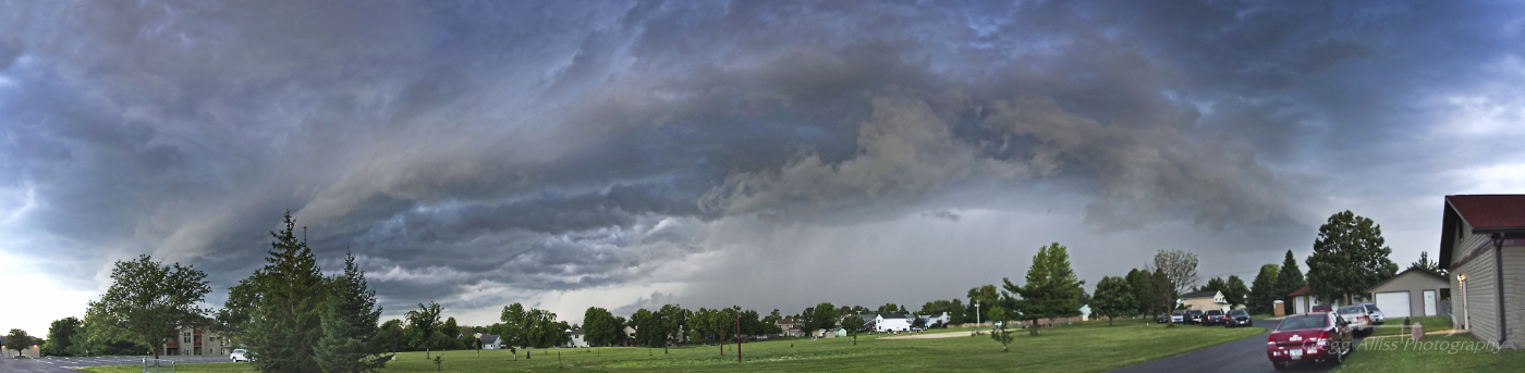
8:31 pm. Panorama looking west (left) and northwest. The line of storms is now taking on a shelf cloud (outflow) appearance.


8:31 pm. Looking northwest.


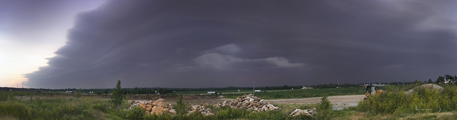
8:36 pm. Looking south from the BP station. The wall of the dark cloud of the storm is now quickly approaching from the right, and wind is beginning to pick up.


8:39 pm. Storm has arrived. Wind gusts here were around 60 mph, with dust and dirt being kicked up in big swirls. I decided to high tail it for home, turning left (east, background) on County Home Road. Very soon, tumbling debris from a house's driveway struck the right front of my vehicle, alarming me, but causing no apparent damage. Just a short distance to the southeast, Cedar Rapids missed most if not all of the southern edge of the storm and was spared! Nikon Z6ii camera.


Read more...

Smoky Setting Sun, Rising Moon

Wednesday, June 11, 2025


Continued Canadian wildfire smoke drifting southward fouled air quality but enhanced sun and moon risings and settings in Iowa. Both of the posted images today were from the evening of Tuesday, June 10, 2025. Above, the setting sun is seen in the northwest sky at 8:33 pm CDT on Alburnett Road, about .3-mile north of Echo Hill Road in Marion, Iowa. Image is a 1/100 second exposure at f/6.3, ISO 160, 70mm focal length. Official sunset was at 8:42 pm.


9:08 pm. Rising Strawberry full moon in southeast sky as seen from North Alburnett Road about .8-mile north of County Home Road, north of Marion, Iowa. Image is a 2/5 second exposure at f/7.1, ISO 160, 65mm focal length. Nikon Z6ii camera. A "Strawberry" moon is defined as a full moon that occurs in the month of June. Official moonrise was at 8:46 pm.

Read more...

A Blip in a Quiet Season

Thursday, June 5, 2025


Eastern Iowa, and more specifically the Cedar Rapids metro area has been abnormally quiet when it comes to severe weather thus far in 2025. So even though some non-severe storms moved through the area on Tuesday, June 3, I was ready with my camera. The above image looks northeast as seen from the Lowe Park ball diamond parking lot in Marion, Iowa at 4:27 pm CDT. The leading edge of the storm can be seen at right background as it passed overhead and toward the "two o'clock" position of this image.


4:29 pm. Looking southeast. Cloud movement here was right-to-left. This storm cell produced moderate amounts of lightning, wind and rain. Nikon Z6ii camera.


This Radarscope image from 4:26 pm shows the line of non-severe storms, with my position indicated by a white target icon. Some isolated tornado-warned areas near Mount Pleasant and Burlington in southeastern Iowa did form from this system.


4:31 pm. Radarscope reflectivity (top) and velocity images.

Read more...

Smoke Screen

Tuesday, June 3, 2025


An observed Coronal Mass Ejection (CME) observed on Saturday, May 31, 2025 and directed toward Earth promised a G4-class solar storm and probable significant aurora (northern lights) displays as far south as the midsection of the United States. There was just one problem: ongoing Canadian wildfires emanating from Manitoba and Ontario were drifting south and southeast veiling those skies in a layer of thin but opaque smoke. The smoke did enhance the appearance of the sun and moon but blocked most stars and the accompanying ghostly auroras. An example of an enhanced sun is seen above, looking east from the parking lot at Noelridge Christian Church in Cedar Rapids, Iowa at 7:34 am on Sunday, June 1, 2025.


NOAA wildfire smoke forecast map for Monday, June 2, with an arrow showing my location.


12:30 am CDT, Monday, June 2, 2025. With high hopes but ultimately with nothing to show for it, I positioned myself on North Marion Road, about 2.2 miles north of County Home Road, and about 1.5 miles southeast of Alburnett, Iowa in Linn County. At first I hoped the luminous area seen above was aurora, but it didn't move or fluctuate, so I quickly realized this was a hazy reflection from a town--in this case Central City, Iowa.


Aurora Alerts app for 12:25 am, June 2. The southern penetration of the aurora covers most of Iowa.


12:41 am. June 2. Looking west. An example of an enhanced setting crescent moon. Because of wildfire smoke the moon appears orange. 8 second exposure at f/4.5, ISO 1250, 24mm focal length.


12:42 am. June 2. Looking north. A final attempt to capture even a faint glimpse of aurora. But only the brightest stars at top appear in this 20 second exposure. Left empty handed.


Next night/morning. 12:31 am CDT, Tuesday, June 3, 2025. Looking north from a parking lot at Lowe Park in Marion, Iowa. Again, nothing but the brightest stars and terrestrial light sources are visible. (Possible dim aurora just right of the smaller tree).


12:33 am. Similar shot from near the Lowe Park ball diamond. Drifting clouds--not aurora--are seen at upper left. Nikon Z6ii camera.


Aurora Alerts images and data for 12:41 am. Very frustrating and disappointing as a cameraman in response to the no-show!


Read more...

  © Blogger template On The Road by Ourblogtemplates.com 2009

Back to TOP