Fast Intensifiers On June 24
Wednesday, June 26, 2019
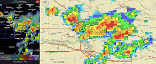
A scattered cluster of small benign storm cells in eastern Iowa suddenly began to intensify around the Cedar Rapids area on the afternoon of Monday, June 24, 2019. A hefty cell began entering my location in Hiawatha as the two radar images above show--the left at 2:27 pm CDT, and the right at 2:30. Driving heavy rain with 60-plus mph winds at that time prompted a report by me to the National Weather Service in the Quad Cities and minutes later the area just east of here went severe warned.
Above, the storm system continues east (background) as seen from Progress Drive and Martha's Way in Hiawatha at 3:01 pm. Mammatus can be seen in the cloud mass at left center. This was an iPhone 6-Plus camera capture.
By 3:15 pm I had found my way to Alburnett Road and Flight Drive in the Bowman Meadows housing development in Marion, Iowa. The above storm panorama from 3:17 pm spans from east (left) to south (right). This distant area was again severe-warned.
A radar screen capture closely corresponding to the above and below photos. My location is indicated by the target icon, with a line of sight arrow pointing to the distant updraft area residing about 50 miles distant, northwest of Davenport, Iowa.
3:17 pm. Looking southeast at the severe storm's updraft from Alburnett Road and Flight Drive in Marion.
3:18 pm. At nearly the same time, a weaker by still photogenic storm cell had also begun to form about 11 miles to my northeast (above).
3:23 pm. A zoomed-in view of the distant updraft of the departing severe-warned cell. By now the most intense part of this storm was about 55 miles to the southeast, and about 10 miles northwest of Davenport. Nikon D7200 DSLR camera.


0 comments:
Post a Comment