Nonexistent Severe Weather Season So Far For Cedar Rapids

Wednesday, May 26, 2021


According to official numbers, the severe weather and tornado season for Cedar Rapids, Iowa in the spring of 2021 is the lowest it has been in 20 years! Most severe weather activity for the year has been taking place in the central plains of the United States. Because of this, storm structures in Cedar Rapids have been few and far between to photograph. Some of the highlights of the "garden variety" storms that have happened in the city are captured here from Sunday evening, May 23. The images look west from Bowman Woods Park. The above image is from 5:23 pm CDT.

Radarscope image for 5:24 pm, showing the storm cell approaching Cedar Rapids. This cell did not contain lightning.


5:45 pm.


5:56 pm.


5:57 pm. Nikon D7200 DSLR camera.

Read more...

Icy Sky, Icy Air to Come

Tuesday, April 20, 2021


Sunset at Bowman Woods Park in Cedar Rapids, Iowa on Sunday evening, April 18, 2021 included this beautiful sun halo. Sun halos are created by ice crystals high in the atmosphere. This icy sky was a precursor to unseasonably cold air temperatures in the days to come. Image captured at 6:23 pm CDT. Nikon D7200 DSLR camera.

Read more...

Ten Years Ago, Epic Western Iowa Tornado Outbreak and Chase

Thursday, April 8, 2021


Where has the time gone? A decade has passed since Saturday, April 9, 2011 and the participation in my first "real" storm chase--that is: one where researching a "hot spot" was conducted, driving to a selected and distant location which was at the moment experiencing fair weather, waiting a lengthy period of time for storm initiation, responding to the initiation and following the storm system east, continually staying on its southeast flank. My son Ryan, who had earned his meteorology degree from Iowa State University the previous December, researched severe weather models that Saturday morning to determine if a chase was feasible. By the time the Storm Prediction Center (SPC) posted the convective outlook shown above (11:21 am CDT), Ryan was convinced of good results for a chase, despite strong capping inversions present in the predicted area of western Iowa. We left Cedar Rapids for Ames, Iowa, where we met up with six of his meteorology student friends for a short strategy session concerning the coming chase. Included in this group were: Nick Carletta, Bryce Link, Ethan Milius, Tristan Morath, Tyler Roney and Sam Schreier. Our selected location to wait out storm initiation was a Casey's at Minden, Iowa on Interstate 80, and an abandoned former convenience store site just to its north. By 4:55 pm with the cap broken and a supercell already exploding skyward to our west, we were at last underway. The group was now chasing what would turn out to be an epic tornado outbreak in western Iowa, and we would view 5-8 tornadoes before the night was done.

5:50 pm CDT. Storm chasers Bryce Link, Sam Scheier, Nick Coletta, Ryan Alliss and Tristan Morath view the growing supercell from about 3 miles west of the Onawa, Iowa Interstate 29 exit.

6:19 pm. Bloated supercell with mini funnels looking west while northbound on Interstate 29, just south of County Highway E24. (Bryce Link capture with my camera)

6:36 pm. Building supercell looking back south while eastbound on Highway 141, just south of Hornick, Iowa. 

7:08 pm. Circulation aloft that would become the Mapleton, Iowa EF3 tornado. This location was just west of Ute, Iowa, and about 8.5 miles southeast of Mapleton.

7:22 pm. Panorama looking north at developing tornado as seen from Sumac Avenue, about 7 miles southeast of Mapleton. 

7:24 pm. Looking northwest at EF3 tornado just before it impacted Mapleton. The tornado would destroy 60% of the town.

7:32 pm. Storm chasers Bryce Link, Sam Scheier, Nick Carletta, Ethan Milius, Ryan Alliss, Tyler Roney and Tristan Morath view the EF3 tornado as it leaves the Mapleton area. The location was Sumac Avenue at 170th Street, about 5 miles southeast of town. 

8:12 pm. Storm chasers look north in 50-plus mph RFD winds from Keystone Avenue at 330th Street, one mile west of US Highway 59, and about 8 miles south of Ida Grove, Iowa. From left: Tyler Roney, Bryce Link, Ryan Alliss and Gregg Alliss. (Tristan Morath video frame capture)

8:30 pm. Driver Ryan Alliss observes tornado while northbound on County Highway M31, south of Arthur, Iowa. All tornado images from here on were video frame captures, illuminated by lightning.

8:32 pm. Stationary along County Highway M31, looking north, about one mile south of Arthur. Tornado is about 2.5 miles to our northwest, on a northeasterly track.

8:38 pm. Chasers looking north at low rotation from Hope Avenue at Highway 175 (330th Street), two miles east of Odebolt, Iowa. This EF3 tornado was on a northerly track.

8:38 pm. Multi-vortex tornado. 

8:56-8:57 pm. Long exposure of a vivid lightning display looking northeast from 255th Street, about one-tenth mile east of US Highway 71 and 2.5 miles southeast of Early, Iowa. Strong RFD winds are blowing the trees in the background. The dark area at left is a supercell with a tornado on the ground at this moment. We were cautioned by a highway patrol trooper here who then sped on up the road at right.

9:10 pm. Too close! EF3 wedge tornado to our northwest as we are northbound on County Highway M50, approaching the center of town at Nemaha, Iowa. The tornado is less than 2 miles distant, and we later determined the strong probability of being in its outer circulation. We made a quick and safe escape east at the center of town.

9:46 pm. Stationary and looking north at supercell as seen from County Road D15 at County Road N33 (leading off into the distance), about 1.5 miles west of Knoke, Iowa. Long exposure image. Red lights in the distance are from a wind farm. High RFD winds made stabilization of the camera image difficult. The day's chase ended here, and we finally rolled back into Cedar Rapids around 1:15 am, April 10--exhausted but safe and exhilarated. Nikon D5000 DSLR images.


Read more...

Palm Sunday Moon Day

Sunday, March 28, 2021


Palm Sunday on March 28, 2021 featured a full moon. These two images captured the moon at 6:39 am CDT as it was setting in the west sky as seen from Bowman Woods Park in Cedar Rapids, Iowa. The top image is a 1/320 second exposure at f/5.6, ISO 1000 and 300mm focal length, the bottom image a 1/320 second exposure at f/4.2, ISO 1000, 105mm focal length. Nikon D7200 DSLR camera.


Read more...

Tornado Tease

Saturday, March 27, 2021


A line of precipitation that at first seemed benign moved in a northerly direction in Eastern Iowa on the evening of Tuesday, March 23, 2021. To my surprise, my weather radio sounded at 7:15 pm. A radar indicated tornado warning had been issued for extreme southeast Iowa (left panel above). A half-hour later another tornado warning was issued for Washington County, just south of Iowa City and Johnson County (right panel). These warned areas were occurring along the leading edge of this system. Both warnings were cancelled in short order. White arrows show storm motion, red polygons the warned areas, and the black target icon my location.

In response to this situation, I positioned myself on our back deck in case new warnings might pop up closer to home. None did. A serpentine-like line of rain undulated north bringing our area some heavy rain and elevated wind. The image above looks south at the approaching line of rain. iPhone 11 camera.

Radarscope image roughly corresponding to the time of the photograph above it. Note the red colored line of heavy rain, and the blue target icon indicating my location.


Read more...

And It Begins...

Friday, March 12, 2021

A severe-warned storm cell is seen along the northwest horizon, looking over Bowman Woods Elementary School in Cedar Rapids, Iowa at 5:47 pm CST, Wednesday, March 10, 2021. The most intense area of the storm was located about 64 miles distant, south of the town of Holland, in Grundy County Iowa. The storm cell was severe warned for about 20 minutes, starting at 5:35 pm. This was the first severe weather event in this area for 2021, and was an earlier-than-normal occurrence for the season. A current La Nina pattern in the Pacific Ocean--similar to that of 2011--has some severe weather models predicting higher-than-normal activities for the year. Could this be the start? Nikon D7200 DSLR camera.

Radarscope image closely corresponding to the photograph at top showing the severe-warned polygon. 

The severe weather event on March 10 was for the most part unexpected. At the start of day the Storm Prediction Center (SPC) posted chances of mild thunderstorms over Iowa, and less than 2% tornado probability. But by 1:52 pm a Slight Risk was posted for Central Iowa (above), with a 5% tornado probability.


Tornado Watch 16 posted for central and northeast Iowa at 2:40 pm CST.

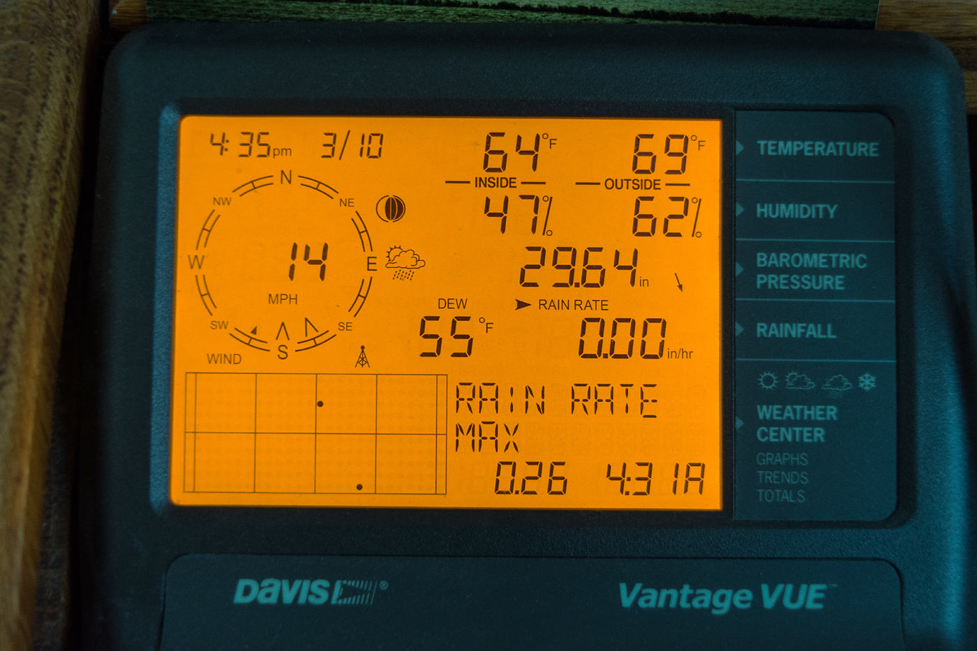
My weather station monitor at 4:35 pm, showing very springlike conditions.

WeatherTap radar screen for 6:14 pm CST, showing copious amounts of lightning and the tornado watch areas. These storms quickly weakened and became linear, containing rain and some wind, and rolled through the Cedar Rapids area around 8:00 pm.


Read more...

Resilient Crocus

Monday, March 8, 2021


Just a couple of days before the capture of this trio of crocuses poking up above ground in our backyard the surface was covered with snow, and just a month earlier occurred a two-week stretch of double digit sub-zero temperatures. Time and date here was 3:58 pm CST, Monday, March 8, 2021. Photographed from Cedar Rapids, Iowa. Air temperature was 63 degrees F. Nikon D7200 DSLR camera.


Read more...

  © Blogger template On The Road by Ourblogtemplates.com 2009

Back to TOP