Cristobal Exits

Wednesday, June 10, 2020


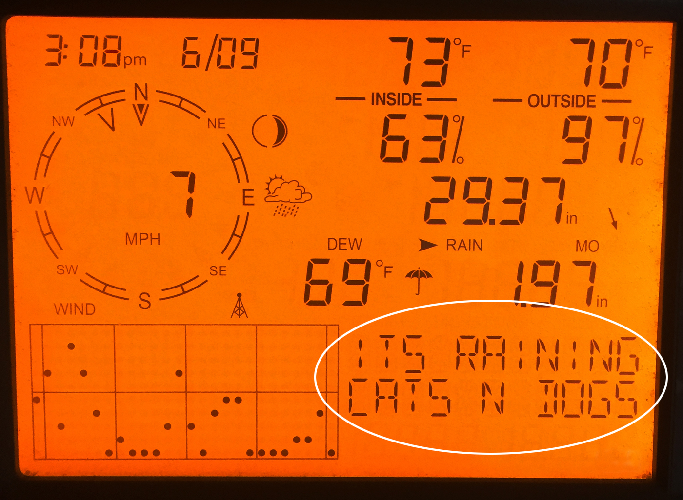
Rains from Tropical Storm Cristobal arrived in the Bowman Woods area of NE Cedar Rapids, Iowa around 11:00 am CDT, Tuesday, June 9, 2020. An indication of heavy rain was later humorously displayed on my Davis Instruments Vantage Vue weather station (above). When Cristobal finally moved out of this location around 6:15 pm, 1.81 inches of rain had fallen. The barometric pressure from this intense low pressure system had bottomed-out at 29.28 inches around 6:05 pm.


Around 7:00 pm skies to the west briefly opened some, revealing a background vista of mid-level altocumulus clouds. This image looks WNW over Bowman Woods Park in Cedar Rapids at 7:10 pm.


Similar view at 7:12 pm.


Corresponding radar capture. Target icon indicates my location. Black arrow shows the camera's viewing direction for the top two photos, white arrows indicate Cristobal's storm track.


Bank of clouds looking southwest at 7:14 pm. Clouds were moving right-to-left in this image. In a short amount of time, skies would again cloud over. Nikon D7200 DSLR camera.

Read more...

Severe Weather Terminator

Saturday, June 6, 2020


Storm Prediction Center (SPC) Categorical Day 1 Convective Outlook, posted at 2:48 pm CDT, Thursday, June 4, 2020. Much of the state of Iowa was in a Slight Risk. Little did I know that on this day I would seek out three separate severe-warned storms, and all three of them would inexplicably lose their warnings just a few miles in front of me.


A line of storms began firing up northwest of Cedar Rapids, Iowa around 12:45 pm and went severe-warned around 1:30 pm, prompting me to head out on the road in pursuit. Early in the intercept (above), I am northbound on Highway 13, just south of County Home Road (E34) at 1:49 pm. The most intense part of the severe-warned cell seen in the distance was located about 16 miles away, near the town of Troy Mills in Linn County. In five minutes this storm's severe warning would expire.


Undaunted, I turned east on County Home Road, then north on County Road X28 to a spotting position at 120th Street, southwest of Stone City in Jones County. Despite the dropping of the severe warning, skies were still dynamic. This panorama, .5-mile southwest of Stone City,  looks north at a vista of mammatus formations at 2:11 pm.


2:13 pm. Similar image capture with updraft at center, then back toward home.


New severe-warned cells were approaching from Grundy County around 4:40 pm. I waited to see what these would do from a good open spotting location in the Bowman Meadows housing development in Marion, Iowa. This magnificent strong updraft graced the southeastern sky as seen from Alburnett Road at Bowstring Drive at 4:50 pm. The storm was located about 41 miles distant, near the town of Lowden in Cedar County.


5:07 pm. The beautiful mushroom cloud continues to expand as it moved away. The storm was now about 51 miles distant, near the town of Grand Mound in Clinton County. The dark area at top of the image is the edge of yet another anvil cloud. Meanwhile in Black Hawk County, the aforementioned severe-warned storm was persisting and continuing to advance east. Time to travel north on Interstate 380 with another intended intercept.


Radarscope capture for 5:28 pm, showing the advancing severe-warned cell and my location (blue target icon).


5:38 pm. Northbound (NW) on I-380 in northern Benton County, about 3.25 miles south of Brandon, Iowa in Buchanan County. The severe warning was dropped on this storm two minutes later, so I turned around at Brandon and returned home yet again. GoPro Hero 4 video frame capture.


After picking up some food for dinner, I returned to the Bowman Meadows area of Marion for another spotting setup. At Quiver Court there, a beautiful anvil cloud is shown (above) in the southeast sky at 6:29 pm, located about 60 miles distant near Columbus City in Louisa County.


Yet another storm--this one in Benton County--had gone severe-warned around 6:40 pm and was tracking toward me. Above is a Radarscope image for 7:02 pm, showing the storm and my position.


7:08 pm. Panorama looking northwest from Quiver Court, just south of Boyson Road at an incoming shelf cloud. The shelf cloud contained a small embedded funnel on its leading edge at center. Two minutes later this storm's severe warning was also canceled.


7:08 pm. Closeup of the funnel.


7:08 pm. Similar capture with vertical orientation.


7:13 pm. Looking north toward Boyson Road at the leading edge of the shelf cloud. The storm was about 4.5 miles distant.


7:14 pm. Similar capture. Storm is 4 miles away.


7:15 pm panorama of the storm, very close to me now. The gust front produced heavy rain, winds and lightning. I had faced-off on three separate severe-warned cells on this day, and all three of them of them had withered and died! Total driving distance was about 97 miles. Nikon D7200 DSLR camera.

Read more...

Long Distance Love Affair

Thursday, June 4, 2020


With severe weather forecasts for Wednesday, June 3, 2020 being predicted in extreme northern Iowa only, I paid only mild attention to radar throughout the day. Instead, I spent a large portion of the day doing yard work, and was quite tired by its end. A dinner meal, then welcomed relaxation on the couch to watch TV. Very quickly I began to get sleepy and was near the nodding off point when I received a text message from friend Mike Graber (W0WWX) at 6:49 pm. Mike posted a picture of an absolutely gorgeous storm cell that had popped up in the Quad Cities area. This got me off the couch! I took a quick walk down the block for a look toward the southeast to see if it was viewable from my position. Through a thicket of trees I could only make out an enticing top layer of clouds, so back to the house and into my car. Driving a short distance east on Boyson Road in Marion, Iowa, I neared a more open sky area of the Bowman Meadows housing development. As I did so, I almost gasped at the sight of the beautiful spreading anvil and vigorous updraft of the distant storm that now came into view, and quickly found a place to stop for photography. Above is a panorama from Alburnett Road in the housing development looking southeast at 7:03 pm CDT. The storm was about 55 miles distant, with its most intense area being about 6 miles southeast of Durant, Iowa. The distance from edge-to-edge of the anvil in the image was about 50 miles.


7:03 pm. Zoomed-in capture of the updraft area. Note the rippled edges of the anvil.


Weather.us base velocity and echo top captures for 7:05 pm. Rotation (circled area, left panel) was weak in the most intense area, but cloud tops there reached over 55,000 feet (right).


An overshooting top peeks above the storm's anvil (upper right) in this capture from 7:05 pm. This was the highest area of echo top altitude.


7:09 pm. Panorama image of the storm from Alburnett Road and Bowstring Drive in Marion. This isolated storm began to form west of Davenport around 3:35 pm, and was severe-warned from 7:10-7:55 pm. For the most part, the cell remained in the same general area, actually performing a slow retrograde motion to the south and then southwest. It finally dissolved around 10:45 pm, northwest of Burlington, Iowa.


Close-up of anvil and updraft at 7:14 pm. After 8:30 pm with growing darkness, the anvil took on a pinkish hue and was laced with lightning. Nikon D7200 DSLR camera.


Radar image corresponding to 7:25 pm. This image clearly shows the isolated nature of the storm. My viewing position is indicated by the target icon.


A Radarscope frame capture for 7:37 pm. I was enthralled by the structure of this beautiful storm and would have been very disappointed and frustrated had I not been forewarned of its presence and fallen asleep and missed it!

Read more...

Swift Blow Through

Monday, June 1, 2020


A quick-moving storm system during the morning hours of Thursday, May 28, 2020 created turbulent appearing clouds as it passed through. Heavy rain, high winds and lightning occurred after the clouds exited. The above image looks north at 10:30 am CDT from Bowman Woods Park in Cedar Rapids, Iowa.


10:30 am. Looking east.


10:31 am. Looking south. Nikon D7200 DSLR camera.


Radar image corresponding to 10:32 am. Storms were moving in an unusual southwest track. White target icon indicates my position.

Read more...

May 26, 2020 Severe Weather in Benton County, Iowa

Friday, May 29, 2020


Storm Prediction Center (SPC) Convective Outlook, posted at 7:50 am CDT, Tuesday, May 26, 2020. Categorical, tornado, wind and hail outlooks are shown, with the greatest potential for all forecasted over central Iowa.


By 12:30 pm CDT Tuesday the SPC posted a Mesoscale Discussion (735) with a 60% probability of a severe thunderstorm watch (above).


At 1:20 pm Tornado Watch 229 was issued (above) including all of central Iowa.


Only five minutes later a tornado warning was issued for an area of Dallas County, just west of Des Moines (WeatherTap radar images above), then at 1:45 pm a severe thunderstorm warning was issued for Washington County in southeastern Iowa. All storms in Iowa had a peculiar NNW track this day. Because of that, I had a particular interest in the Washington County severe storm as its track would most likely bring it west of Cedar Rapids. With spotting equipment already packed and ready to go, my target was US Highway 30, and I quickly departed for an intercept.


2:12 pm CDT. Westbound on US Highway 30, .75-mile east of Highway 287 (27th Avenue) in Benton County. A forming wall cloud is evident, located about 20 miles to my southwest.


2:15 pm. Continuing westbound on Hwy. 30. Wall cloud is becoming more defined.


2:15 pm. Wall cloud looking southwest from near the construction site of US Highway 30 at US Highway 218 in Benton County.


2:16 pm. Zoomed-in capture of the wall cloud.


2:16 pm. Similar capture. Wall cloud is located near the town of Hartwick, in Poweshiek County.


Radarscope image capture corresponding to the time of the photo above it, showing my position (blue target) in relation to the newly designated tornado-warned storm polygon area.


2:23 pm. Continuing westbound on Hwy. 30. Looking southwest at the wall cloud from about .2-mile east of Highway 200 in Benton County.


Weather.us base velocity (left) and echo top captures for 2:27 pm, also showing my position (target icon) in relation to the hot spots.


Pulling off Hwy. 30 at County Road V40 (13th Avenue) in Benton County around 2:25 pm, I began spotting operations and phoned-in a wall cloud report to the National Weather Service in the Quad Cities. The wall cloud (seen above at 2:27 pm) was about 8 miles to my southwest and moving left-to-right in the image.


Radarscope capture for 2:29 pm.


2:30 pm. Wall cloud is about 6 miles to my west (background).


2:30 pm. Panoramic version of the scene.


2:33 pm. Deciding to stay with this storm as it began to move past me, I headed north on V40 and almost immediately received a tornado warning emergency alert on my cell phone.


2:35 pm. Looking west while northbound on V40 (13th Avenue). The wall cloud is beginning to exhibit a more outflow appearance.


2:37 pm. Looking west at storm from V40, 1.5 miles north of US Highway 30 in Benton County.


2:39 pm. Horizontal version of image above it.


2:41 pm. Looking northwest from V40, 1.5 miles north of Hwy. 30. Departing tornadic storm is now about 10 miles distant.


2:41 pm. Departing storm with my spotting vehicle in foreground.


2:56 pm. All tornado warnings in the state had now been lifted. This image looks west at a distant towering updraft with a lowering beneath it while northbound southwest of Vinton, Iowa. I briefly considered intercepting this storm--located about 35 miles away in Tama County--but deemed it a waste of time due to the cancellations.


3:05 pm. Rain curtains southwest of Vinton.


3:10 pm. GoPro Hero 4 Silver video frame capture. Caught in a brief, but intense wind and rain storm southeast of Dysart, Iowa. Rain was blowing across the highway reminiscent of those from RFD winds.


3:12 pm. A stationary look at the departing storm that had rolled over me two minutes before.


3:34 pm. GoPro video frame capture. Westbound on gravel road about 2.5 miles east of Elberon, Iowa in Tama County. Scud is rising into distant cloud feature, located about 5 miles distant.


3:35 pm. GoPro video frame capture. Northbound on gravel road. Most intense part of storm in background was located about 23 miles to the NNE, near the town of Raymond, in Black Hawk County.


3:39 pm. More scud feeding into previously viewed cloud, seen here to my west from 63rd Street, about 3.5 miles southwest of Vinton. Cloud is about 17 miles distant.


3:47 pm. Panorama looking north at storm cell from 19th Avenue, about 5 miles southwest of Vinton in Benton County.


3:47 pm. Similar capture.


4:05 pm. Looking southeast while southbound on US Highway 218 (65th Street) at 24th Avenue, about 5 miles south of Vinton. The approaching line of severe-warned storms in the distance was located about 60 miles away, near the town of Bennett in Cedar County. I was returning home at this moment. These storms would eventually roll through Cedar Rapids, but without much impact. Total driving distance: 132 miles. Nikon D7200 DSLR camera.

Read more...

  © Blogger template On The Road by Ourblogtemplates.com 2009

Back to TOP