Epic Storm Chase, Great Bonding

Sunday, May 5, 2024


Discussions of high instability, warm fronts, triple points and atmospheric forcing in the region of eastern Nebraska, northeastern Kansas, northwestern Missouri and western Iowa several days in advance of Friday, April 26, 2024 all indicated the potential for a significant severe weather event. The Storm Prediction Center (SPC) posted an Enhanced Risk for these areas two days in advance. Above are National Oceanic and Atmospheric (NOAA) forecast graphics for the Tornado Outlook (left) and Hail Outlook, valid from 12:30 pm CDT on April 25.


My son Ryan had five days off from work starting Thursday, April 25 and we discussed the possibility of a  storm chase for April 26, with an additional two days (April 27-28) of storm chasing on the table. Conditions continued to look favorable for severe weather (including strong tornadoes) early in the morning of April 26. We left Cedar Rapids, Iowa just after 9:00 am with the towns of Shenandoah or Atlantic, Iowa as our target areas. As we approached these areas however, a severe-warned cell was already firing up near the town of Belleville, Nebraska (Radarscope image above) at 12:47 pm, and tracking to the northeast toward Lincoln. With no time to lose, the decision was made to continue forward across the Missouri River and into the state of Nebraska. 


About the same time, Mesoscale Discussion 526 was posted, with a 95% probability of the issuance of tornado watch for the designated area (shown) being forecasted.


12:55 pm. Tornado Watch 140 is issued for much of the eastern half of Nebraska, and extreme western Iowa, valid until 7:00 pm CDT.


Forming severe-warned supercells are evident in this radar image at 1:10 pm.


1:26 pm. Close-up radar image in the Fairbury, Nebraska area with areas of hail evident within the severe-warned polygon.


1:33 pm. Supercell storms are intensifying, with the center storm now tornado warned. All storms are tracking to the northeast.


1:40 pm. Tornado-warned cell is tracking toward Lincoln, Nebraska and our current chase location (target icon).


1:42 pm. Second supercell near the town of Friend, Nebraska goes tornado warned. 


1:47 pm. Close-up radar image of same area.


1:53 pm. Radarscope close-up dual-pane image, with reflectivity image at top and velocity image at bottom. Reflectivity image shows a forming tornado "hook echo" signature. The bottom image shows the bright area of a tornado couplet.  


Similar more expansive view of the image above it. The red dots are storm chasers.


Ryan Alliss' electronic chasing equipment (top-to-bottom): iPhone 15 Pro for streaming, GPS, Radarscope.


2:05 pm. Storm chasing now begins in earnest. Image looks north at swirling clouds from I-80 ALT, located about 2.5 miles southeast of Seward, Nebraska, indicating a volatile atmosphere. 


2:09 pm. We are now located north of Seward, and having to make the choice of intercepting the more northern tornado warned supercell (left) or the more southern one at lower right. Our position is the blue target icon. 


2:25 pm. Image looks northeast along Road 322, about 2.5 miles west of Seward, Nebraska in Seward County. Ryan points his cell phone toward the sky while streaming, with mammatus clouds in the background.


2:32 pm. First Emergency Alert sounds on my cell phone!


2:37 pm. Looking northwest at a vigorous cauliflower updraft as seen from the northern outskirts of Seward, Nebraska in Seward County.


2:43 pm. Looking northwest from the side of Highway 280, just south of Highway 808, about 5 miles north of Seward, Nebraska. Ryan observes developing tornado-warned storm.


2:45 pm. Same location. Looking north at rotating storm. Clear slot at left. Updraft and inflow cloud at right. Note the line of storm chasers in the background at right.


2:55 pm. We are momentarily pulled off to the side of Highway 15, about .7-mile south of the junction with Highway 66 in Butler County, Nebraska. This vigorously rotating storm would produce our first tornado in mere minutes.


2:55 pm. Back on the road again. A Dwight (Nebraska) Rural Fire Truck parks in the middle of the road about .6-mile south of Highway 66--not to block traffic, but to warn of the danger ahead. 


2:56 pm. Looking north from Highway 15 at Highway 66. This brief, weak tornado dropped just as we were approaching the intersection. Note the striking circular rotation around the funnel, and the storm chasers stopped in the foreground. 


2:56 pm. Closer-in image.


2:58 pm. We have turned right (east) onto Highway 66 and pulled off to the side of the road a short distance from Highway 15. A funnel drops to the ground in this view looking north. Like the first tornado, this was a brief and weak event. 


2:59 pm. The tornado lifts after having been on the ground for just a few seconds.


2:59 pm. Ryan streams the storm.


3:00 pm. Similar view looking northeast.


3:10 pm. Looking southeast at anvil topped supercells, as seen from Highway 66 about 4 miles east of Dwight, Nebraska in Butler County. These tornado-warned storms would eventually move into Iowa and impact the town of Minden. 


3:11 pm. Similar view.


3:18 pm. Eastbound on County Road A in Saunders County, Nebraska, about 2.8 miles southeast of Valparaiso, Nebraska. Although not distinct in this image, ground circulation indicated a tornado contact.


3:18 pm. Second Emergency Alert.


3:32 pm. We observed hailstones on the side of the road while traveling on County Road A in Saunders County, Nebraska, about 4.6 miles east of Ceresco. Many were very large in size! The fallen hail was confined to a small area--maybe a half-mile. We did not see any hail falling. This is the first hailstone I collected--shaped sort of like a hockey puck.


3:34 pm. A conglomerate style hailstone.


3:37 pm. Using my trusty measuring caliper on a hailstone and discovering it measured an astounding 3.8 inches in width--the largest hailstone I've ever seen!


3:46 pm. Looking south at storm while eastbound on Ashland Road, about 1.75 miles west of the town of Ashland, Nebraska in Saunders County.


4:10 pm. Radar image with a very distinct tornado hook echo signature, located near Washington, Nebraska, just northwest of Omaha.


4:28 pm. Our location is just north of Omaha (target icon), tornado-warned polygon areas, and we're heading toward Iowa.


4:35 pm. Incredibly active radar image of the Omaha area.


4:48 pm. No surprise here--another Emergency Alert.


5:07 pm. University of Illinois Doppler On Wheels (DOW) truck seen while we were northbound on Laredo Avenue (L23), about 3.3 miles southeast of Pisgah, Iowa. The DOW team was led by Dr. Josh Wurman. 


5:23 pm. Looking north from Lincoln Way Street near US Highway 30 (background left) in Woodbine, Iowa in Harrison County. Leading a line of storm chasers is the University of Illinois Doppler On Wheels (DOW) truck. 


5:25 pm. Northbound on Loess Hills Trail about 3 miles north of the town of Missouri Valley, Iowa in Harrison County. Wedge tornado can be seen on the horizon.


5:33 pm. Yet another Emergency Alert, this one adding "A dangerous storm is approaching current location. Tornado threat: high."


5:39 pm. Ominous Radarscope image for 5:39 pm, with hail over the town of Minden, and the distinct hook echo of a tornado about to arrive from the south. We did not fully know about the disaster that had befallen Minden until the next day, but unfortunately had a good idea it would happen from this image. Our location target icon is just northeast of the town of Tennant.


5:44 pm. Traveling south (southwest) on County Road M16, about 1.4 miles northeast of Tennant, Iowa. Wedge tornado at center background.


5:47 pm. Looking southwest at a multi-vortex tornado as seen from County Road M16, about .7-mile south of the town of Tennant, Iowa in Shelby County. The tornado had just devastated the town of Minden.


5:51 pm. Looking southwest at two tornadoes on the ground--broader tornado (background), and satellite tornado in the foreground. We are stopped on Street F58, with County Road M16 in the background. Storm is approaching our location.


5:51 pm. Single tornado in an ever-changing vortex whirl.


5:52 pm. Satellite tornado back on the ground, accompanying the main tornado.


5:52 pm. Yours truly posing in front of the oncoming tornado. (Ryan Alliss photo)


5:52 pm. Close-up of two tornadoes on the ground.


5:52 pm. The car at right came up to us and exclaimed, "Are you alright? Do you need help?" After we assured them we were fine, they sped off toward the left. The tornado would track over this very spot a short time after we had departed from it. 


5:53 pm. The tornado moves relentlessly forward, and appears to have momentarily lifted. It was now time to go! We followed the direction of the vehicle in the background. 


5:54 pm. Racing briefly toward the tornado's track, but then a quick turn away east (left). The storm appears as a low hanging wall cloud at this moment, but would recycle into a wedge tornado in just minutes. Ryan shouted to me, "you'd better get your pictures of it now, because we're getting out of here!"


5:56 pm. Stationary again. Looking west at approaching wedge tornado as seen from Street F58, about 5 miles southwest of the town of Harlan, Iowa in Shelby County.


5:58 pm. Wedge tornado draws nearer and was moving toward the lower right in this image. I had the impression of an evil living, breathing entity as it relentlessly churned on. 


5:58 pm. Simliar image.


5:58 pm. Similar image. 


5:58 pm. Ryan streams the wedge tornado from beside our vehicle. The tornado passed 1.25-mile to our northwest. Inflow winds here were around 30-40 mph.


6:06 pm. Looking northwest at wedge tornado while northbound on US Highway 59 on the south edge of Harlan, Iowa in Shelby County.


6:08 pm. Vigorously rotating wedge tornado looking northwest from our stationary position on Highway 44 on the west edge of Harlan. 


6:20 pm. Looking at rotating updraft structure, still containing the wedge tornado, while northbound on County Road M47 in Shelby County, Iowa. Nikon Z6ii camera.


9:17 pm. iPhone 11 video frame capture. Eastbound on Interstate 80 near Newton, Iowa, driving inside a tornado-warned storm. Around this time after an epic and tiring storm chase, we decided to forego the chasing of the next two day's severe weather setup, and returned home to Cedar Rapids just before midnight.


During this storm chase I debuted my experimentation of the Nikon app "Snapbridge," which connects to my Nikon mirrorless camera via Bluetooth, and geo-stamps the latitude/longitude coordinates of each capture. This experiment was successful and proved invaluable in recording our locations.


11:08 pm. DOW data analysis of Harlan tornado. There were 19 confirmed reports of tornadoes in Nebraska and Iowa on this day. (The state of Iowa experienced a record 41 tornadoes in the month of April).


Our storm chasing map for Friday, April 26, 2024, includes tornado tracks in our general vicinity. The epic 15-hour, 865-mile chase saw 5-6 tornadoes, and was highlighted by the visually amazing high-end EF3 Harlan tornado. But on a more serious note, our thoughts and prayers go out to those whose lives and property were impacted by the Omaha and Minden events. 


Read more...

First Taste of Significant Severe Weather in Eastern Iowa

Friday, April 19, 2024


Anticipation for a significant severe weather event in the midwest was running high two days in advance of its expected arrival with the Storm Prediction Center (SPC) posting an Enhanced (Level 3) risk at that time. Pictured above is the updated posting for 12:30 pm CDT for Day 1, April 16, 2024. The panel on top shows an area of Enhanced Risk covering much of Eastern Iowa, with the bottom panel showing a 10% hatched area for a tornado risk. 


Around the same the National Weather Service (NWS) issued Tornado Watch 117, covering eastern Iowa, northeastern Missouri and western Illinois, and valid until 8:00 pm CDT, April 16.


My Tempest Weatherflow home weather station data for 1:06 pm, showing juicy conditions for the formation of severe weather.


Time to secure a mobile spotting position! This image (2:37 pm) shows the array of informational and communication devices in my vehicle, now located on North Marion Road (10th Street) just north of County Home Road, north of Marion, Iowa. Go Pro Hero 4 Silver Action Camera (1), cell phone with radar (2), CB/Weather radio (3), amateur radio (4), Vantage Vue weather station console (5). The Cedar Rapids NOAA weather radio (WXL61) transmitter was not operating during this event, but I was able to pick up surrounding broadcasts.


And meanwhile, weather was becoming active. This Radarscope image for 2:41 pm CDT shows an incoming line of storms moving on a NNE track. My activated Spotter Network target icon is at center. Note the severe and tornado warned polygons all over the region. 


2:40 pm CDT. Looking northwest at an area that would become tornado warned in mere minutes. The storm was located about 30 miles distant in Buchanan County.


Active radar image for 2:55 pm. Note the tornado-warned polygons (red) to the north. 


2:57 pm. Looking south from North Marion Road toward Marion and the direction from which the civil defense sirens were now sounding. County Home Road is seen in the background.


3:25 pm. Looking southeast at a low cluster of clouds, moving right to left in this image. Tornado warned areas were just east of this location.


3:30 pm. Looking northeast. Area in the background is tornado warned (see radar image below). My spotting vehicle is in the foreground.


Radar capture for 3:32 pm. Note how the first line of storms (upper right) was leaving my area and the new line (bottom left) was approaching, still as potent as ever. 


3:35 pm. This is what the southwestern sky looked like during a lull in the two lines of severe storms. It was at this time I decided to pick up and relocate to the south, with the intent of intercepting a stronger line of storms which was approaching the town of North Liberty in Johnson County.


4:05 pm. Southbound on Interstate 380 with the Eastern Iowa Airport exit (Exit 13) seen in the background. The line of storms (right) was approaching fast, and at this point it quickly became apparent I wasn't going to reach North Liberty in time.


4:07 pm. Fast change of plans and pulling into the southbound Interstate 380 rest area just south of Cedar Rapids. The storm (moving right-to-left in the image) is almost upon me.


Radar image corresponding to the photo above it. White arrow points toward the storm.


4:08 pm. Stationary at the rest area now. Image looks southwest at a lowering feature along the squall line.


4:11 pm. Severe-warned storm is now blowing over me. This image looks southeast. About a minute later pea size hail began to fall, with a duration of about a minute. 12 tornadoes in Iowa from this storm system were determined by the NWS on this day, with a long-track EF2 tornado occurring in the Salem/New London area in the southeastern part of the state being the most significant. Nikon Z6ii camera.


Read more...

Eclipse Day Did Not Disappoint

Wednesday, April 10, 2024


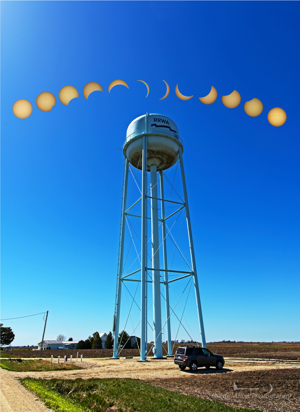
I had originally envisioned a solo drive to Carbondale, Illinois for the upcoming total solar eclipse on Monday, April 8, 2024. Estimated driving time would have been about 6 hours one way. Conflicting weather forecasts one week in advance began to leave me uneasy--one day forecasting clear, the next cloudy. I soon had to make a decision, and since I had already witnessed the awesome totality of the 2017 eclipse in Columbia, Missouri, it seemed a shorter trip option might be preferable, even though it would result in a partial eclipse. Two days before the event forecasts showed confidence that southeastern Iowa would be cloud free. Now I had to research an area that might include interesting foreground elements, hopefully tall church steeples or wind mills. Finding none, I settled for an isolated water tower located about 4.4 miles east of the town of Mount Union, Iowa in Henry County. This would be a much more suitable drive of about one hour, 20 minutes. The graphic appearing above shows information for this targeted location about 4 1/2 hours before maximum eclipse coverage, and listed 89.7% for maximum eclipse. 


12:16 pm CDT, Monday, April 8, 2024. Selfie at my targeted location by the water tower, about a half hour before the beginning of the eclipse sequence and wearing my 2017 Snoopy & Charlie Brown eclipse t-shirt.


Composite image of the eclipse sequence looking southwest. Each individual sun capture is positioned in this image to their approximate location in relation to the camera's perspective. Time captures are, from left: 12:36 pm, 12:50 pm, 1:05 pm, 1:23 pm, 1:42 pm, 2:02 pm, 2:10 pm, 2:20 pm, 2:39 pm, 2:58 pm, 3:09 pm, 3:20 pm. Captures were 1/2000 second exposures at f/8, ISO 100, 70mm focal length. Post processing achieved using ON1 Photo Raw 2023, Affinity Photo 2 and CS4 Photoshop. Nikon Z6ii camera with Neewer HD ND100000 72mm solar filter. I moved the lens away from the sun after each shutter release (10 second delay), and repositioned it again for the next capture. Maximum eclipse was directly over the water tower as I had planned.


A four-image sequence leading up to maximum eclipse (far right). A sunspot at center of the disk can be seen. At maximum (89.7%), the sky resembled a hazy day, not unlike during skies from Canada or western wild fires. The air also noticeably cooled, forcing me to zip up my jacket. 


1:27 pm. The water tower, backlit by the eclipsing sun. iPhone 11 camera. 


1:50 pm. A crescent shape (arrow) in my shadow from the unfolding eclipse created by making a small opening with my left hand. For leisure viewing of the eclipse sequence, I broke my Eclipser HD glasses out of storage from the 2017 total eclipse.


3:04 pm. A ring effect created by the sun behind some isolated cirrus clouds near the end of the eclipse sequence. For almost all of the eclipse event the skies remained clear. To my utter surprise, in the nearly four hours at this location, not one vehicle drove by me! The overall experience did not disappoint and was definitely worth the effort! 


Read more...

Solar Eclipse Is Just 12 Days Away-- Test Mode

Wednesday, March 27, 2024


The total eclipse of the sun is just 12 days away, and it was time to test my solar filter, especially if I opt not to drive the six hours (and six hours back) to southern Illinois where totality will take place on April 8. This image was captured at 3:48 pm CDT on Wednesday, March 27, 2024 and was made possible by using a Neewer 72mm HD ND 100000 solar lens filter. It is a 1/2000 second exposure at f/8, ISO 100 and 67mm focal length. Note the appearance of sunspots on the disk. In Iowa, the eclipse will appear similar to a half moon. Nikon Z6ii camera.

Read more...

Just a Sliver of a Moon

Tuesday, March 12, 2024


The ultra-thin waxing crescent moon on the evening of Monday, March 11, 2024 in Cedar Rapids, Iowa still shone beautifully because of its "earth shine" affect. This image, a one-second exposure at f/4, ISO 500, 70mm focal length, was captured at 8:14 pm CDT, and looks west from Bowman Woods Park. Illuminated houses below the moon are from the street neighborhoods of Chatham Road, Windsor Drive and Crandall Drive NE. Air temperature was a mild 61 degrees F. Nikon Z6ii camera.


Read more...

Leap Day and Hints of Spring

Friday, March 1, 2024


Leap Day, February 29, 2024, was one day removed from a morning low temperature of 8 degrees F, but signs of spring were still making subtle appearances on our property in Cedar Rapids, Iowa. Top left, lilac buds; top right, tulip greens; bottom left, crocus; bottom right, quaking aspen buds. Nikon Z6ii camera.

Read more...

  © Blogger template On The Road by Ourblogtemplates.com 2009

Back to TOP