Distant Storms Disappear

Wednesday, May 11, 2022


A distant line of thunderstorms can be seen low on the western horizon in this capture from Bowman Woods Park in Cedar Rapids, Iowa at 8:04 pm CDT, Monday, May 9, 2022. Although the storms packed some punch in western and central Iowa, they completely broke apart before they reached this location. Air temperature at this moment was 84 degrees F, dew point 69 degrees. In the background is Bowman Woods Elementary School. Nikon D7200 DSLR camera.


Radarscope capture, corresponding to the time of the image above it. The target icon was my location, with an arrow pointing to the storms in the picture.

Read more...

April 30 Line of Storms Blow Through

Sunday, May 1, 2022


A line of non-severe storms blew through the Cedar Rapids, Iowa area on Saturday, April 30, 2022. This was a precursor to a larger, "main event" that occurred farther east into Illinois later in the day. Above, the line of storms approaches my spotting location at Noelridge Christian Church in Cedar Rapids from the southwest at 2:55 pm CDT. 


2:56 pm. Looking northwest at the approaching gust front, forming a bit of a shelf cloud.


2:58 pm. Gust front almost overtaking me. High wind speeds never exceeded 30-35 mph at this location as the front blew through. Nikon D7200 DSLR camera.


Radarscope image corresponding to 2:49 pm. The blue target icon indicates my position.

Read more...

Early Morning Planetary Parade

Wednesday, April 27, 2022


Four planets aligned themselves in the eastern sky (actually five, if you include the too-dim-to-capture Neptune) during the early morning hours of Wednesday, April 27, 2022. Above, clear skies at 5:05 am CDT allowed the viewing of the planetary parade. From bottom left to upper right: Jupiter (magnitude -2.10), Venus (-4.11), Mars (0.89), Saturn (0.86). Image was captured from the Bowman Meadows housing development in Marion, Iowa and was a 5 second exposure at f/4, ISO 400, 24mm focal length. The illuminated area at lower left is a power substation located on Alburnett Road just south of Boyson Road. Air temperature was a chilly 35 degrees F.


5:28 am. Looking east from 33rd Avenue at 12th Street SW in Cedar Rapids, Iowa. Above the waning crescent moon is Jupiter (left), and Venus. The two planets were about 3 degrees apart and are moving toward their closest encounter on Friday. Image is a 1.3 second exposure at f/6.3, ISO 320, 55mm focal length. Nikon D7200 DSLR camera.

Read more...

First Iowa 2022 Severe Weather Event Was a Deadly One

Tuesday, March 8, 2022


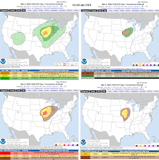
Forecasts for Iowa and severe weather had been predicted some three days in advance of the deadly EF4 tornado that would eventually take the lives of six people in Winterset, a town in Madison County, and one near Chariton, in Lucas County on Saturday, March 5, 2022. Storm Prediction Center (SPC) categorical, tornado, wind and hail outlooks are shown above, posted at 10:29 pm CST that morning.


As hours progressed and storms began to fire up in southwest Iowa, other SPC postings appeared, such as Mesoscale Discussion (MD) 194 at 1:20 pm, Tornado Watch 27 at 2:05 pm, and MD Discussion 195 at 3:46 pm.


Also of interest to Eastern Iowa, was this ominous Thunderstorm Outlook posted at 2:17 pm.


As evening approached and darkness began to fall, advancing storm strengths were still holding up. I set up my spotting location at Noelridge Christian Church in Cedar Rapids. The above image looks northwest at a tornado-warned area some 35 miles distant at 7:08 pm CST. 1.6 second exposure at f/3.5, ISO 500, 18mm focal length.


Radarscope video frame capture comparable to the photo above it, showing tornado-warned polygons to my west and northwest, and my location icon colored in blue. 


7:09 pm. Looking northwest.


7:10 pm. Looking west.


7:12 pm. Looking southwest.


7:14 pm. Looking southwest. Lightning illuminated. I made no severe weather reports here as conditions remained below reporting criteria as the storms passed through. Nikon D7200 DSLR camera.


GoProHero4 video frame stills from around 7:30 pm, looking in the same direction and showing lightning flashes. 


Scary looking Radarscope radar image capture from about 4:30 pm on March 5, showing a very pronounced hook echo signature (circled) where the tornado resided. Thoughts and prayers go out to the family and friends of those who lost their lives there!


Read more...

Dazzling Sunset Two-fer

Friday, March 4, 2022


The consecutive evenings of March 2 and March 3, 2022 treated the viewer with dazzling sunsets. Above,  a vibrant Ash Wednesday western sky is seen at 6:14 pm CST on March 2 from Noelridge Christian Church in Cedar Rapids, Iowa. Air temperature was 46 degrees F. Official sunset on this day occurred at 5:58 pm.


6:01 pm CST, March 3. Another evening of brilliant skies. This time I had another treat as I heard the honking approach of a formation of Canada geese, and waited for them to flew into the fiery sky for a capture (top of image).


6:04 pm. In the car and westbound here on Brentwood Drive NE. Alto-cumulus clouds have provided a wonderful reflective quality for the sunset spectacle, shown here around the height of its brilliance. Air temperature was 30 degrees F.


6:10 pm. Looking west from the intersection of C Avenue and Collins Road NE. The sunset has now faded considerably, but bright colors still persist along the horizon. Nikon D7200 DSLR camera.


Read more...

That's No Moon, It's a Weather Station!

Saturday, February 26, 2022


To me, the greatest resource and attribute a severe weather spotter can possess is accurate wind speed measuring. Unfortunately in my history of spotting that attribute has been, to be honest, inaccurate. My existing Davis Instruments Vantage Vue weather station, installed in July, 2012, has been a good unit. Wind speed indications, however, have always appeared slightly lower than other readings reported from other weather stations, TV reports, etc. Part of the problem probably is the fact a hill at Bowman Woods Park, laden with mature trees, rises to almost roof height behind our house. This hill, and the trees probably provided protection to our house from damage during the serious derecho event on August 10, 2020. Because of the continuing wind speed discrepancy, I began to peruse other upgrade alternatives. One of the choices was the ultrasonic wind sensor, which uses 4-6 sensors to determine wind direction and speed, and has no moving parts (wind vane, anemometer cups). Some of these products cost in the $1,000-2,000 range, and that was not in my budget. After some research, I found the wireless Tempest Weatherflow weather station. Resembling a large microphone, the compact station uses the ultrasonic wind technology, and includes many other features such as: temperature, dew point, humidity, air pressure, lightning detection, rain amounts, UV strengths and reading histories. The price for the unit is around $350. My objective for purchasing the new station was not to replace the old one, but to supplement it. I would also mount the new station to the old. My new Tempest Weather station arrived in early January, but obviously with the cold and snow on the roof, installation would have to wait for better conditions. Better conditions came on February 20, with high temperatures reaching 58 degrees F in Cedar Rapids. Above, the installation components are laid out on a table on February 18. They are: A. 1.25 inch X 5 foot galvanized steel mast pole. B. Four foot copper lightning ground spike. C. Tempest Weatherflow box. D. Hose clamps. E. Copper wire connecter (lightning ground). F. Wireless Wi-Fi hub. G. Hub AC cord and plug. H. 50 foot insulated copper wire. I. Pole mount adapter. J. Tempest Weatherflow unit. K. U-bolts and hardware.


Tempest Weatherflow weather station, coupled with existing Davis Instruments Vantage Vue station. February 20, 2022.


View of the pairing from the opposite angle, with the Bowman Woods Park hill seen at background left. 


After a brief lull with 2.4 GHz wi-fi connectivity issues with our internet provider, the Tempest Weatherflow station was finally online and operational on February 22. Above is the first smart phone readout. Wind speeds from this station show slightly higher wind speeds than the Vantage Vue.


Read more...

Winter's Broad Brush Stroke

Wednesday, February 9, 2022


A broad swath of brilliantly colored sky appeared in an otherwise cold winter's realm in Cedar Rapids, Iowa during the evening of Monday, February 8, 2022. Above, the western sky is photographed from Bowman Woods Park at 5:34 pm CST, three minutes after official sunset. 


Similar capture at 5:36 pm. With the sun continuing to dip lower below the horizon, and with clouds moving in, the vivid scene diminished to dimming grays in just a few minutes. Air temperature was 37 degrees F. Nikon D7200 DSLR camera.

Read more...

  © Blogger template On The Road by Ourblogtemplates.com 2009

Back to TOP