Tornado Outbreak in Iowa July 14, 2021

Sunday, July 18, 2021


Storm Prediction Center (SPC) convective outlooks on Tuesday, July 13, 2021 were showing an Enhanced Risk of severe weather a day before the event would occur, and this prompted some serious attention on my part. Forecasts for Eastern Iowa on the morning of Wednesday, July 14 called for morning storms to roll through before a redevelopment of severe weather in the afternoon and evening, and indeed this occurred. The images above show an approaching storm at 10:41 am CDT (left) and again at 10:50 am, looking west and northwest from 33rd Avenue and 12th Street SW in Cedar Rapids, Iowa. These morning storms brought some wind, heavy rain and pea size hail to the area. iPhone 11 camera.

As the morning storms passed and the sun came out again, the atmosphere was becoming unstable, and Tornado Watch 378 (above) was posted at 2:38 pm CDT.


Following close on the heels of the tornado watch was a new SPC posting at 2:48 pm (above), indicating a similar area of Enhanced Risk, but a greater tornado probability (10% hatched) for Iowa. 


I admittedly got a slow start setting out north from Cedar Rapids to catch storms that were forming in central Iowa. These storms went tornado warned around 4:00 pm. My route for interception was Interstate 380. In the (4:42 pm) Radarscope image above, I navigate north (northwest) on I-380 to catch up with the two tornado-warned cells. My location is indicated by the blue target icon at right. 

5:10 pm CDT. Cloud tops from the tornado-warned system are now becoming more obvious in this view while northbound (NW) on I-380, about .35-mile north of the Brandon, Iowa exit (330th Street) in Buchanan County. The storms were about 30 miles distant, and some of their cloud tops were reaching 60,000 feet.

Radar image capture corresponding to the photograph above it.

5:18 pm. Looking west at the leading edge of the southernmost cell from about 6 miles south of the I-380/US Highway 20 interchange. The storm cell was about 30 miles distant.

Radar image for 5:30 pm, showing the northernmost cell and my approach to it.

5:36 pm. Looking west at tornado on the ground while northbound on Highway 54 (Canfield Road), about .9-mile north of the intersection of Highway 57 (East Cedar Wapsi Road) in northern Black Hawk County. Tornado was about 12 miles distant. 

Radar image capture corresponding to photograph above it.


5:37 pm. Similar image to previous photograph.


5:39 pm. GoPro Hero 4 video frame capture. Westbound on East Marquis Road, about 8 miles east of Denver, Iowa, along the Black Hawk/Bremer county line. The tornado was about 6-7 miles distant.


5:40 pm. Tornado on the ground (at right and seconds from lifting) seen while westbound on East Marquis Road, about 8 miles east of Denver, Iowa, along the Black Hawk/Bremer county line. The tornado was about 6-7 miles distant.


5:43 pm. The tornado has lifted, but the wall cloud from where it had emanated remains. Looking west from my first stationary spotting location on Tahoe Avenue at Marquis Road along the Black Hawk/Bremer county line. The approaching wall cloud is about 3 miles distant.


Radar image capture closely corresponding to the photograph above it.


GoPro Hero 4 video frame captures of CG lightning emanating from the storm. Time range was 5:42-5:46 pm.


5:46 pm. A view of my spotting position.


5:48 pm. Approaching wall cloud.


5:52 pm. Similar view.


6:00 pm. With the tornado-warned storm drawing ever closer to me, and with a large number of good storm shots already captured, I decided to head back south the way I had come, anticipating processing these captures upon arriving at home. The emergency alert image seen above occurred as I started my way home. As I headed back south on I-380, my radar showed another tornado-warned cell approaching the town of Center Point in northern Linn County from the west. With a good two hours of daylight left and a great spotting location option at the large truck stop there, this became my new objective.


Radar image capture for 7:08 pm. Two tornado-warned polygons are approaching my stationary spotting location (number 2) at the Center Point truck stop (Center Point Travel Plaza). The Linn County ARES amateur radio net is activated at this development and I check in.


7:11 pm. Looking west at the leading edge of the approaching storm. 


8:17 pm. Looking WSW at a dangerous lowering feature that was not well defined to my naked eye realtime as it was rain wrapped and of very low contrast. The camera brought out much more vivid detail in post processing later.


8:20 pm. Another frightening image of a funnel cloud, less than three miles distant, resolved better by the camera. For better or worse, I now decide to pull out of this location and continue south on I-380. 


Velocity radar for 8:20 pm, showing the area of the image above this one, and my location.


8:26 pm. One last parting shot of the funnel captured through the front driver's side window as I sped south, and south of Center Point. My next (and last) spotting location objective was the Toddville, Iowa exit, just one exit north of Cedar Rapids. 


8:32 pm. Pulling off on the west side of the Toddville exit (County Home Road), the rain had stopped, revealing this beautiful "mother ship" feature, complete with "stacked cake layers" and a ragged wall cloud hanging low to the ground beneath it. In my haste to jump out of my vehicle and fire off quick shots of the storm feature before it changed or dissipated, low light conditions caused some blurring in the next few images. This image looks WNW.


8:33 pm. Similar shot. Storm was about 7 miles distant.


8:37 pm. Storm structure has two unusual horn-like protrusions above the lowering, and is beginning to form a tail cloud at right.


8:38 pm. Similar capture.


8:43 pm. Now using a tripod. Storm, about 7 miles distant, has moved toward the northeast (left-to-right in this image), and is now seen in the north sky. Interstate 380 is at right in the background.


8:46 pm. Similar capture. Note low wall cloud.


8:47 pm. Mesocyclone is now featuring numerous tendrils and a "cap."


8:49 pm. Storm continues to move away to the northeast.


8:59 pm. This is a GoPro Hero 4 video frame capture of the storm as it is illuminated by a brilliant lightning flash.


8:59 pm. Similar GoPro capture.


9:01 pm. The southwestern segment of this tornado-warned storm now drifts into view, this one sporting a shelf cloud. This storm is about 9 miles distant.


9:03 pm. Striking capture of both cells in the same image, with the more distant cell moving out.


9:04 pm. Large shelf cloud to north.


Radar image capture corresponding to 9:05 pm. The west and east tornado-warned cells are indicated with black arrows, the target icon being my location. White arrows indicate storm track.


9:07 pm. Similar capture with prominent tail cloud at right.


9:12 pm. Panorama of closer storm cell.


9:13 pm. With darkness settled in and storms moving away from my general area, I decided to check out of the Linn County ARES net and call it a night. What a day it had been! My limited area of operation was part of a day in which 26 individual tornadoes were confirmed in Iowa--the third most ever in the state for a 24 hour period! Nikon D7200 DSLR camera.


Read more...

Unsettled Weather

Saturday, July 10, 2021


This was the view to the west from Bowman Woods Park in Cedar Rapids, Iowa as a line of storms approached. Time and date was 5:35 pm CDT, Friday, July 9, 2021. Nikon D7200 DSLR camera.


Radarscope view of the approaching storms closely corresponding to the photo at top, with my position shown as the blue target at right.


7:31 pm. The storms have passed and a long lasting double rainbow emerges. This iPhone 11 camera image looks east from Napoli's Italian Restaurant on 7th Avenue in Marion, Iowa.


Read more...

Stormy Clouds on Horizon

Friday, July 2, 2021


A line of clouds, containing rain and some wind but no lightning during the evening of Saturday, June 26, 2021 made for a striking horizon display, but didn't do much else. Above is a capture of the clouds, seen in the northwest sky from the sledding hill at Bowman Woods Park in Cedar Rapids, Iowa at 7:10 pm CDT. Nikon D7200 DSLR camera. Below is a radar capture from 7:04 pm, showing the line of approaching storms and my location (blue target icon).

*****

Derecho Update: Numbers are in from the derecho cleanup in Cedar Rapids, Iowa. Over 10 months after the August 10, 2020 devastating storm, city cleanup of the debris was finally completed. Over 4 million cubic yards was collected (which would be like filling The University of Iowa's Kinnick Stadium to the brim six times over!). A staggering 675,000 damaged trees were collected.


Read more...

Iowa Severe Weather Comes Out of Hibernation

Thursday, June 24, 2021


After a historical drought of severe weather and tornadoes in the state of Iowa for 2021, the storms finally made a significant return on Sunday, June 20, 2021. When all was said and done, two confirmed tornadoes had touched down and many areas of damage were reported. The image above shows a Radarscope image corresponding to 4:48 pm CDT. The severe warning of this cell, at the time located near the town of Colfax in central Iowa, prompted my movement south from home to the planned location of North Liberty, Iowa. 


5:47 pm. In position at the Green State Credit Union headquarters in North Liberty and looking northwest. The most intense area of the severe-warned storm was located near Grinnell in central Iowa, about 57 miles distant. 


Similar image from 5:52 pm. Very soon, I realized the storm's track would be south of me, so I decided to head to Hills, Iowa--south of Iowa City.


I parked at the Casey's convenience store, with the intention of waiting for the approaching storm. While there, I captured this image of a separate severe storm, seen through the clouds, located about 76 miles to the northwest near Waterloo, Iowa at 6:34 pm. The severe warned storm directly to my west soon began weakening, and although a tornado warned cell trailed it a little farther south and west, I decided to head back home. Light availability was waning, and new severe-warned cells were approaching Cedar Rapids from the northwest.


By the time I returned to my general neighborhood area, these storms had also weakened. Above, a picturesque line of clouds approaches from my position at Alburnett Road at Bowstring Drive in the Bowman Meadows housing development. Panorama image looks north at 8:30 pm.


8:33 pm. Beautiful back-lit clouds looking northeast.


8:33 pm. Looking northwest.


Two days later (June 22), and another storm pushes east and quickly becomes severe warned. This cell slid north of my position near home in Bowman Woods Park in Cedar Rapids. This image was captured at 5:33 pm CDT, with the most intense area of the storm cell being located just east of the town of Urbana in northern Linn County, about 14 miles distant. 


Radarscope capture, corresponding to 5:39 pm.


5:40 pm. Looking northwest at the storm, as seen from the sledding hill in the park.


Similar image from 5:41 pm. The elementary school is seen in the foreground. Nikon D7200 DSLR camera.


Read more...

Makoshika Sunset

Saturday, June 12, 2021


More vacation skies. These two Nikon D7200 DSLR camera images were photographed just after sunset on Tuesday, June 1, 2021. Location was Makosika State Park near Glendive, Montana. The above image was captured at 8:52 pm MDT and is a 1/200 second exposure at f/9, ISO 160 and 25mm focal length. The  image below was shot at 8:57 pm and is a 1/200 second exposure at f/7.1, ISO 160 and 25mm focal length.


Read more...

Impressive Looking Rain Tease

Friday, June 11, 2021


A strong--but not severe--storm cell intensified as it moved southeast near Alburnett, Iowa around 4:00 pm CDT on Thursday, June 10, 2021. By about 4:30 pm it was packing a rather robust hail core. The rain potential from this cell was almost certain to provide welcomed precipitation to thirsty landscapes, currently suffering from drought conditions. The storm's appearance was very impressive too, with an extended forward-reaching anvil and black sky in its downdraft region. Above is a panoramic view of the storm looking north at 5:13 pm, seen from Alburnett Road and Bowstring Drive in the Bowman Meadows housing development in Marion, Iowa.

5:25 pm. Lots of potential here. Vigorous updrafts and numerous rumbles of thunder in the approaching cell. Within 20 minutes however, most of the cell had almost completely fizzled out. Only a few light sprinkles ever reached the ground here. Nikon D7200 DSLR camera.


Radarscope capture of the storm cell corresponding to 5:07 pm. Storm motion was to the southeast. The blue target icon indicates my position. 


Read more...

Montana and North Dakota Provide Sunsets, Stars and Noctilucent Clouds

Monday, June 7, 2021


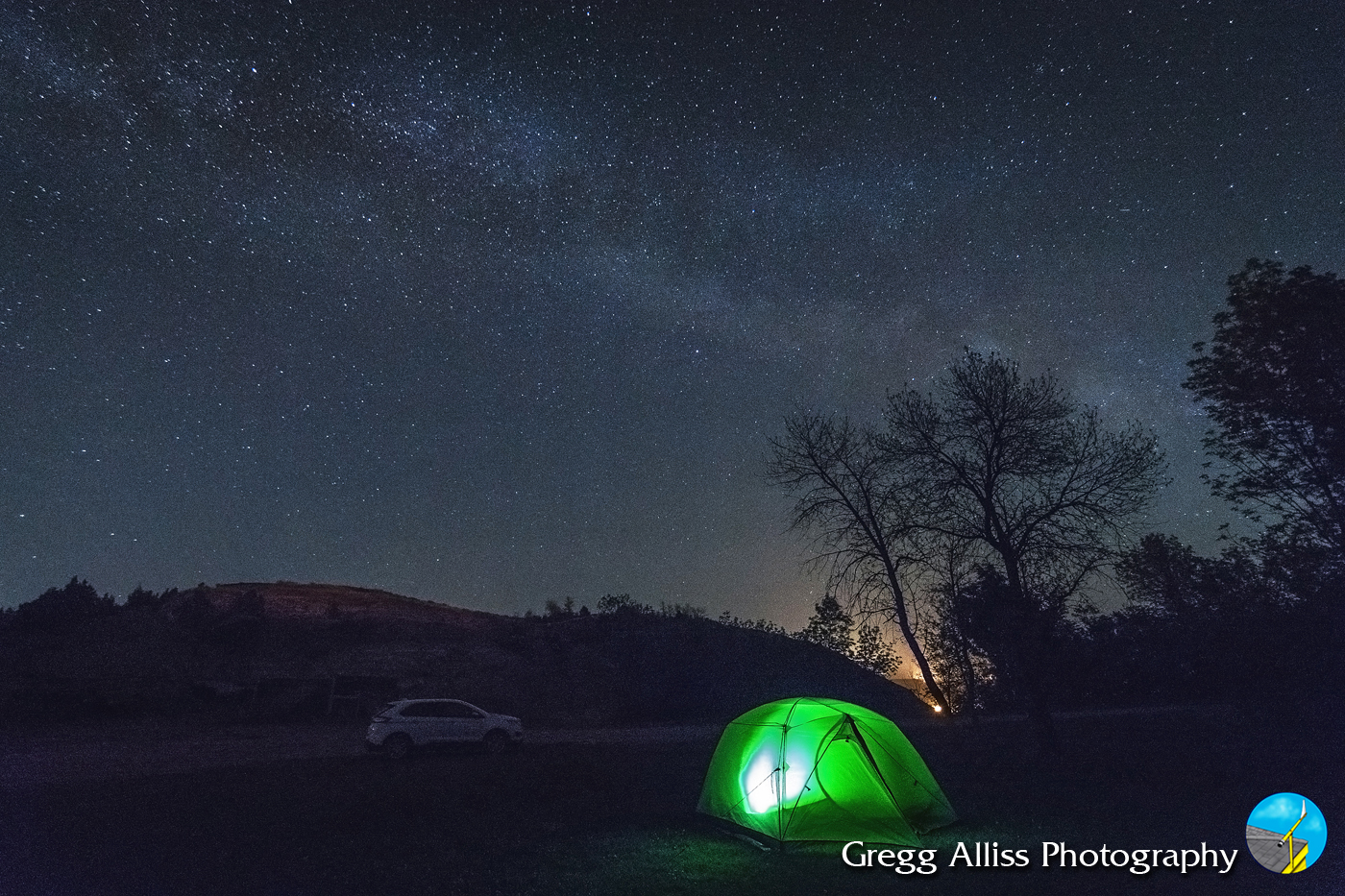
Recent vacation to western North Dakota and eastern Montana provided for some beautiful captures, and in one case, a rare sky capture. Above, the Milky Way spans a Badlands horizon toward the east as seen from the Little Missouri State Park campground north of Killdeer, North Dakota. Image was captured at 12:00 am MDT on Monday, May 31, 2021 and is a 2.5 second exposure at f/2.8, ISO 10000, 11mm focal length. The distant horizon lights are burning gas flares.


12:14 am MDT. Milky Way behind our Little Missouri campsite. 3 second exposure at f/2.8, ISO 8000, 11mm focal length.


8:34 pm MDT, May 31, 2021. Makoshika State Park, just southeast of Glendive, Montana. Sunny skies had given way to gathering dark clouds. The sky was mostly obscured until the moment of this capture, when a gap in the clouds briefly allowed a shaft of sunlight through, illuminating the top of these Badlands features. Sunset was at 8:35 pm. 1/320 second exposure at f/3.5, ISO 200, 18mm focal length.


8:36 pm. The (north) western horizon took on a fiery look as the clouds slowing closed the gap. 1/320 second image at f/4.5, ISO 320, 34mm focal length.


8:36 pm. Similar shot. 1/320 second exposure at f/4, ISO 320, 26mm focal length.


8:39 pm. Fading light and thickening clouds. 1/320 second exposure at f/5, ISO 320, 45mm focal length.


8:40 pm. 1/320 second exposure at f/4.5, ISO 500, 32mm focal length. Nikon D7200 DSLR camera.


Same location, now 9:38 pm MDT. The sun had been below the horizon for just over an hour. Small gaps through the clouds just above the hillside remained, showing an unusual illumination, which at first I dismissed as the lights of the nearby town on Glendive. It soon became apparent the town of just over 5,000 could not be causing this curious bright phenomenon. I soon remembered something called Noctilucent Clouds, though I had never actually seen them myself. 


9:41 pm. Arrows point to three separate areas of noctilucent clouds looking northwest. Noctilucent clouds form by the sun's interaction with ice crystals at extremely high altitudes (250,000-280,000 feet). They are commonly seen in the summer months when the sun is 6-16 degrees below the horizon and from latitudes 50-70 degrees north.


9:44 pm. Glendive is 47 degrees north latitude, and that is probably why the glowing clouds are low on the horizon--being seen higher in the sky farther north. Shortly after this image was captured, clouds began covering the spectacle, and in less than a half-hour a short rainfall ensued. iPhone 11 camera.


8:33 pm MDT, Wednesday, June 2, 2021. Sunset as seen from the Skyline Vista Overlook in the South Unit of Theodore Roosevelt National Park in North Dakota. 1/500 second exposure at f/9, ISO 200, 18mm focal length. Nikon D7200 DSLR camera.

Read more...

  © Blogger template On The Road by Ourblogtemplates.com 2009

Back to TOP