Splash Of Altocumulus

Thursday, August 18, 2011

This altocumulus-dominated sky looks southeast from the parking lot at Noelridge Christian Church in Cedar Rapids, Iowa around 8:20 AM, Sunday, July 17, 2011. The structures in the background left are retail stores near the intersection of C Avenue and Boyson Road NE.

Read more...

'That's No Moon, It's a Space Station...'

Wednesday, August 17, 2011


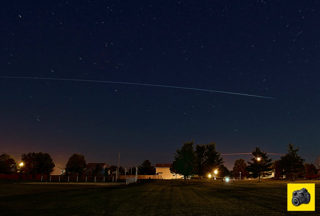
Even though a three-quarters moon was up and rising in the eastern sky, the attraction of the moment was this view of the International Space Station (ISS) as it orbited overhead (left to right in this image) 16 degrees above the horizon. This capture at f/6.3 and 320 ISO was created from an exposure taken from about 10:39-10:43 PM, Wednesday, August 17, 2011. This view looks north from the grounds at Noelridge Christian Church in Cedar Rapids, Iowa, with 74th Street NE in the background. The ISS had also earlier passed over this spot 43 degrees above the horizon just after 9:00 PM. The space station's brightness faded rapidly as it neared the right portion of this image.

Read more...

No Good ISS Tonight

Tuesday, August 16, 2011

These altocumulus clouds were present in the northeast sky around 9:50 PM, Tuesday, August 16, 2011 from just south of Boyson Road (background) and west of Alburnett Road in Marion, Iowa. The clouds thickened around the horizon here ten minutes later preventing a good shot of the orbiting International Space Station (ISS). This image was created by a 33-second exposure at f/6.3, 250 ISO and 18mm focal length.

Read more...

Streamer Meets Step Leader

Monday, August 15, 2011

Okay, the quality of these images is not great. But hey, they were shot at night from a long distance, shot through our chase vehicle's window glass, shot while moving and are video frame captures...With that said, these three images show a streamer (arrow, left panel) moving upward from the ground, meeting a step leader from above as a lightning bolt (middle) and its dissipation (right). These views look east from US Highway 71, about 5.5 miles south of Early, Iowa around 8:50 PM, Saturday, April 9, 2011, and were part of a brilliant lightning display. Streamers form as objects on the surface responding to a strong electric field. The objects reach out to the cloud above by growing positive streamers. If a negatively charged step leader from above meets the streamer, an ionized conductive path is completed creating the flow of current which we know as lightning.

Read more...

Approaching Mapleton

Sunday, August 14, 2011

A tornado, in its early stages, approaches Mapleton, Iowa from about two miles southwest of town around 7:20 PM, Saturday, April 9, 2011. At this point there was not a distinct funnel, and indeed our chase group was not completely sure what it was we were seeing from Sumac Avenue, at the mouth of a farm driveway (toward right). The location was about a quarter mile north of County Highway E34 and about seven miles from both the tornado and Mapleton. This view looks northwest. Note the rain shafts flanking the twister. The tornado would soon grow to EF3 strength, heavily damaging the town. Partially hidden at lower left is storm chaser and Iowa State University meteorology student Bryce Link.

Read more...

Not Quite a Wash

Saturday, August 13, 2011

This bright meteor from the Perseids meteor shower overcame the strong glare of a nearly full moon to be captured in this image, a 25-second exposure at f/4, 250 ISO and 18mm focal length. The image, looking northeast from Brentwood Drive in Cedar Rapids, Iowa, was shot at 1:15 AM, Saturday, August 13, 2011. The meteor streaks through its namesake constellation Perseus--the radiant point--on peak shower day. At upper left is the constellation Cassiopeia. Peeking just above the roof line at lower right is the bright planet Jupiter, magnitude -2.51. The moon was located out of the picture at right and shielded by a large tree.

Read more...

Mega Meso

Friday, August 12, 2011

This massive mesocyclone cloud, taking up a good portion of the sky, was not as visible to the eye as it is in this image. A 12-second exposure at f/8 and an ISO of 250 brought out details the eye had trouble discerning. Frequent lightning flashes provided the exposure's illumination. Getting a sharp image was a difficult proposition here, even with a tripod--sustained RFD winds of near 50 mph buffeted the cameraman. This 12 second exposure reveals a slight blur from the rotation of the storm structure, containing a lowering at left. The meso had produced a wedge tornado near Nemaha, Iowa about a half-hour earlier. This view, shot around 9:45 PM, Saturday, April 9, 2011, looks north from County Road D15, about 1.5 miles west of the town of Knoke, in northwest Iowa. The red lights in the background belong to a wind farm. The road leading off into the horizon and past a farm at left is County Road N33.

Read more...

  © Blogger template On The Road by Ourblogtemplates.com 2009

Back to TOP