Mesoscale Discussion 1754, posted around 4:00 pm, showing areas of interest for possible severe storms in eastern Nebraska and much of Iowa.
Now confirmed as Severe Thunderstorm Watch 560, valid from 5:00 pm.
Radarscope image of the severe thunderstorm watch polygon and forming storms at 5:02 pm.
Storm formation began in far eastern Nebraska and north central Iowa around 1:30 pm. The Nebraska cell went severe-warned around 4:45 pm. The Iowa cell went severe-warned around 5:25 pm, when it was located in northeast Wright County. This cell then went tornado-warned around 5:50 pm. Echo tops in some of these areas soared to a robust 66,000 feet! The three-panel College of DuPage (COD) satellite image above show storm initiation growth at 5:52 pm, 6:09 pm and 6:11 pm.
Radarscope image for 5:58 pm, with severe and tornado warned areas shown west and north of Waterloo, Iowa.
The 6:11 pm image above shows two "eyes" in the cloud tops, probably overshooting tops.
Radarscope image for 6:26 pm. Note the hail core near Iowa Falls at left. It was around this time I headed out to select a spotting location ahead of the approaching storm. I changed my mind for locations north of Cedar Rapids three times! I finally decided to position myself more to the south and west to intercept the "tail end charlie" cell (that contained the hail core) that was tracking to the southeast.
Iowa Environmental Mesonet (IEM) mesoplot for 6:00 pm, showing conditions in my general area (yellow).
7:11 pm. Approaching US Highway 30 from the Interstate 380 on ramp in SW Cedar Rapids, Iowa. The underside of the severe-warned storm's anvil is in the background, the ADM plant in the foreground.
Corresponding radar image, showing the storm cell from the above photograph at lower left, just west of Belle Plaine.
7:29 pm. Now at my stationary spotting location-- at the parking lot of Schrader Tiling & Terrain LLC along the eastbound lanes of US Highway 30 in eastern Benton County, and about 3.25 miles southwest of Atkins, Iowa (41°57'45.69"N, 91°54'58.52"W). Storm clouds are beginning to gather in this view looking northwest.
7:37 pm. The juicy atmosphere was ample for mammatus cloud formations which were located under the thunderstorm's anvil, seen in this view looking southeast over the Schrader facility.
7:38 pm. Mammatus panorama with east direction at far left (and US Highway 30), and south at right.
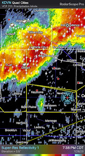
7:38 pm radar screen capture. The former separated "tail end charlie" cell has now joined its neighbors and is forming a squall line.
7:40 pm. Similar mammatus capture.
7:46 pm. Looking north. Vigorous area of updraft.
7:51 pm. Radar image and my location (blue target icon).
7:52 pm. Shelf cloud from approaching storm now coming into view from the northwest. The storm was about 16 miles distant, near the town of Keystone, in Benton County. It was about this time that reports of potential 100 mph winds associated with this storm were circulated. My spotting vehicle is in the foreground.
7:52 pm. Panoramic view of approaching shelf cloud.
7:55 pm. The gust front is now only about 9 miles distant, near the town of Newhall.
Corresponding radar image to photos above and below.
7:56 pm. Shelf cloud panorama. "Whale's Mouth" area forming at left. Storm is about 8 miles away.
7:57 pm. Similar image.
7:58 pm. Looking northeast. Northern flank of storm is about to overtake my position. US Highway 30 is in the background.
7:58 pm. "Whale's Mouth" toward left, as the leading edge overtakes my position from the northwest.
7:58 pm. Dirt and gravel from the parking lot is kicked up from the initial straight line wind gusts as the storm pushes through. I estimated these winds in the 60-65 mph range, exceeding the criteria for severe (58 mph +). Winds while I was here probably peaked at 70 mph, accompanied by torrential rain and dime size hail. Go Pro Hero 4 Silver video frame capture.
8:39 pm. The trailing edge of the storm coming into view to the northwest, with a peek of sunlight creating a brilliant sky. Shortly after this image was captured, I disengaged from this location and headed back toward home. Back toward home, wind speeds had approached 90 mph, knocking out power and downing trees. If I had stayed in the spotting location I left just before this one, I may have experienced that! Nikon D7200 DSLR camera.
9:46 pm. Radarscope capture showing my home location and the trailing end of the line of storms as it tracked through.


