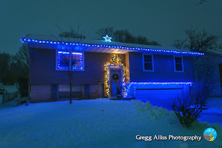
Post-Christmas Lights Display with Snow

Thursday, December 30, 2021


Light snow was falling in Cedar Rapids, Iowa on Wednesday evening, December 29, 2021. The gray skies contrasted nicely with vibrant Christmas lights on our house. The image above was captured at 6:02 pm CST. It is a 1.6 second exposure at f/9, ISO 200, 18mm focal length.


Similar capture at 6:03 pm. 2 second exposure at f/9, ISO 200, 18mm focal length. Weather conditions at the moment were: Air temperature: 15 degrees F, dew point 13 degrees, 95% humidity, 30.00 barometric pressure. Nikon D7200 DSLR camera.


Read more...

Fiery Cold Winter Sky in December

Sunday, December 26, 2021

Despite the fact that air temperatures at this moment on Sunday, December 26, 2021 were a decidedly chilly 19 degrees F, the sky at sunrise appeared fiery hot. This image looks east from Bowman Woods Park in Cedar Rapids, Iowa at 7:15 am CST.


Read more...

Comet Leonard a No-Show to the Planetary Party

Sunday, December 19, 2021


With waning opportunities to see or photograph the fading comet Leonard, one of my last of these was on the evening of Saturday, December 18, 2021. The comet had just transitioned into an evening "star," and was located low in the southwestern sky, bathed in the afterglow of the setting sun. This made photographic capture challenging and difficult. This soon became apparent after several shots with different settings produced virtually nothing. What remained, however, was a nice capture of the three aligned planets. Above, from top-to-bottom, Jupiter, Saturn and Venus glitter over a Christmassy residential area in Marion, Iowa. I captured this shot at 5:31 pm CST atop a large construction dirt pile located on Hampshire Circle, and received frozen fingers in the wind and 26 degree F outdoor temperatures! 3 second exposure at f/8, ISO 320, 18mm focal length.

Read more...

December Derecho

Friday, December 17, 2021

This is December 15 in Iowa?? A 12:38 am CST Public Severe Weather Outlook (PWO) posting by The National Weather Service (above) shows an area of forecasted severe weather later in the day on Wednesday, December 15, 2021. The red area is for a Moderate Risk, a foreboding severe weather designation which is practically unheard of at this time of the year in this part of the country. 

A mature line of severe storms in eastern Nebraska and Kansas were already well in progress at the time of this radar screen capture from 3:05 pm. The white arrows indicate storm movement, the target icon at right is my location.


3:30 pm. My home weather station shows the eye-popping numbers of the sultry nature of current outside weather conditions.

4:04 pm. Looking east from Bowman Woods Park in Cedar Rapids, Iowa. Clouds have a definite spring-like appearance. A nearly-full moon peeks from behind some cirrus at upper left. 


4:45 pm. Ominous SPC categorical convective outlook (left panel), and tornado outlook (right panel) postings.

Tornado Watch 565 goes out for areas of eastern Iowa, southeastern Minnesota, western Wisconsin and northwestern Illinois, valid from 5:30-11:30 pm.


5:44 pm. Radarscope screen capture. Lit-up line of storms with tornado and severe weather warnings continuous from north to south in the state, west of Des Moines. My name and amateur radio call sign can be seen at right.


7:11 pm. Mesoscale Discussion 2036 is posted, with the likely potential for damaging wind gusts and tornadoes shown in the highlighted area.


7:43 pm. Radarscope screen capture. Approaching severe-warned storm is now forming a tight and well-defined linear appearance west of Cedar Rapids and to the south. 


8:00 pm. Approaching line of storms is approaching my position at Bowman Woods Park in Cedar Rapids.


8:15 pm. Looking west at approaching severe weather. Sirens had sounded. Tree tops and clouds are blurred in these images due to high winds and using a one second shutter exposure to capture what little light was available. Wind speeds peaked here in the estimated 60-65 mph range.


8:19 pm. Similar capture. Nikon D7200 DSLR camera. 


Aircraft avoided this massive storm. Shown above is the Flight Aware flight path for United Flight 406, from Denver (left) to New York on December 15. The aircraft departed Denver at 4:12 pm (MST), and arrived in New York at 9:50 pm (EST). Note the significant flight deviation south of the storm!

KCRG TV-9 tornado track map (as of December 22, 2021). 


Cedar Rapids temperatures on this day (high of 73 degrees F) shattered old records. The former high temperature for December 15 was 55 degrees F (1957), and the former high temperature for all of December was 69 degrees F, observed on December 4, 1998. The December 15, 2021 storm was later classified as a "serial derecho." with 43 confirmed tornadoes surveyed by the NWS. That number eclipsed the all-time previous daily high of 30, set on August 31, 2014. This was the first time a derecho has occurred anywhere in the country during the month of December. Also records from the storm was the 55 recordings of 70 mph or higher wind gusts, and 17 of the tornadoes rated EF2 or stronger, breaking the previous mark of 16 on June 7, 1984.


Read more...

Three Planets (and a moon)

Tuesday, December 7, 2021


The skies were rather crowded toward the southwest Monday evening, December 6, 2021, with three visible planets in alignment, and joined by a waxing crescent moon. The above image was captured at 5:23 pm CST from the grounds at Noelridge Christian Church in Cedar Rapids, Iowa. Temperature was 16 degrees F, with very breezy conditions, and my exposed hands while taking several pictures grew numb very quickly! The planets were, from top-to-bottom: Jupiter (magnitude -2.26), Saturn (magnitude 0.70), and Venus (magnitude -4.66). Despite the apparent closeness from the terrestrial observer, Jupiter was 487.8 million miles distant, Saturn was 921 million miles, and Venus was 67 million miles. Image is a 1 second exposure at f/4, ISO 250, 24mm focal length. Nikon D7200 DSLR camera.

Read more...

Festive Lights Above and Below

Thursday, December 2, 2021


A planetary alignment on Tuesday evening, November 30, 2021 augmented nicely the festive terrestrial Christmas lights seen in this SSW view at 5:30 pm CST from Hampshire Circle in Marion, Iowa. Air temperature was 40 degrees F. The three planets were, from top-to-bottom: Jupiter (magnitude -2.29), Saturn (magnitude 0.69), and Venus (magnitude -4.65). Image is a 0.8 second exposure at f/4, ISO 200, 18mm focal length. Nikon D7200 DSLR camera.

Read more...

Long Lunar Eclipse

Friday, November 19, 2021


2:56 am CST, Friday, November 19, 2021. Looking WSW at partial lunar eclipse from the Bowman Woods Park area of Cedar Rapids, Iowa. The eclipse's maximum extent would occur at 3:02 am. Air temperature was a frosty 18 degrees F. Above and right of the moon is the Pleiades Star Cluster, and the bright object at the top left is the 0.84 magnitude star Aldebaran in the constellation Taurus. Image is a 10 second exposure at f/4.2, ISO 320 and 28mm focal length. The composited moon (taken from image below) is a 1/5 second exposure at f/5.6, ISO 320, 300mm focal length, and was captured at 3:04 am. This moon is considered a "Beaver Moon," and the partial eclipse from it was the longest in 580 years! Nikon D7200 DSLR camera.


Read more...

Loess Hills Planets & Milky Way

Friday, November 12, 2021


Conditions in the Loess Hills area of southwest Iowa on the evening of Friday, November 5, 2021 were crystal clear skies, windy and a temperature of 50 degrees F. These two images look southwest from a ridge on the grounds of Horse Creek Adventures, less than three miles west of Sidney, Iowa. The property includes camping cabins, and one of them is seen at lower left. Both images are 10 second exposures at f/2.8, ISO 4000 and 11mm focal length, captured with Nikon D7200 DSLR camera. Top image was at 8:32 pm, and bottom a minute later. In the sky at left center is the -2.46 magnitude planet Jupiter, below and right of Jupiter is the 0.63 magnitude planet Saturn, and just at the horizon below the Milky Way was the -4.46 planet Venus. Sue Alliss is seen just right of the cabin with a head lamp. The Loess Hills were formed more than 25,000 years ago, when a large glacier retreated. As the glacier melted, water filled the Missouri River valley. When the water level dropped, large amounts of silt were left behind.


Read more...

Riding the Ecliptic Train

Saturday, October 16, 2021


8:04 pm CDT, Friday, October 15, 2021. The ecliptic line of a waxing gibbous moon (partially hidden behind the trees) followed by the -2.61 magnitude planet Jupiter and 0.54 magnitude planet Saturn are seen in this southern sky capture from Brentwood Drive NE in Cedar Rapids, Iowa. Air temperature was 49 degrees F. The moon and planets always stay near the ecliptic, which is the apparent path of the sun across the sky. 3 second exposure at f/3.5, ISO 250, 20mm focal length. Nikon D7200 DSLR camera.

Read more...

Foggy Sunrise Along the River

Tuesday, October 12, 2021


The following five images are captures from along the Wapsipinicon River in Wapsipinicon State Park, located in Jones County, Iowa. The rising sun was beginning to burn off the fog that had hung low along the river. The range of time for the five pics was from 7:51 am to 8:02 am CDT, Saturday, October 9, 2021. Nikon D7200 DSLR camera.


Read more...

Lilac Lunacy

Friday, October 1, 2021


Wait, what? Lilac blooms in late September and early October? I had witnessed this phenomenon on this same bush in our front yard a few years ago and in my disbelief researched it. The answer is the weather. Lilacs can occasionally be "tricked" into blooming again in the fall when subjected to unusual or stressful conditions (i.e. dry weather or cool conditions followed by lengthy warm ones). The blooms are shown on the bush on Thursday, September 30, 2021, and as cuttings in a glass the day after. Note the scattered few but vibrant green leaves on the bush near the blooms. iPhone 11 camera.

Read more...

Peaceful Easy Feeling

Saturday, September 25, 2021


A colorful sunset sky provided a serene mood on Friday evening, September 24, 2021. This image looks northwest at 7:31 pm CDT from Bowstring Drive in the Bowman Meadows housing development in Marion, Iowa.


Similar view at 7:34 pm from Bowstring Drive at Bowman Meadows Drive. Air temperature was 60 degrees F. iPhone 11 camera.


Read more...

I See Spots Before My Eyes

Tuesday, September 7, 2021


Alerted by spaceweather.com that large sunspots, big enough to engulf a planet, were rotating into view from Earth on Tuesday, September 7, 2021, so I captured this image of the sun from my back deck in Cedar Rapids, Iowa at 4:12 pm CDT. Nikon D7200 DSLR camera with a Seymour Solar 62mm threaded filter. Image is a 1/500 second exposure at f/5.6, ISO 400, 300mm focal length.

Read more...

Storms, Storms and More Storms

Monday, September 6, 2021


Several August 2021 storms, three in the area and one in Minnesota are posted here. Above, a line of storms approaches 33rd Avenue at 12th Street SW in Cedar Rapids, Iowa from the southwest in this panorama shot captured at 6:24 am CDT on Monday August 23. 

Similar shot taken at same time. iPhone 11 camera.

Severe Thunderstorm Watch #461, posted at 1:50 pm CDT, Tuesday, August 24. 

2:14 pm. Storm cell looking southwest as seen from 33rd Avenue at 12th Street SW in Cedar Rapids.

2:31 pm. Zoomed-in capture.

Radarscope image corresponding to the photograph above it.


3:01 pm. Storm cell panorama. The most intense areas of this severe-warned storm were located about 40 miles distant. Visual distance from left-to-right of this cell was about 70 miles.

Radarscope image corresponding to the photograph above it.

5:45 pm. Incoming shelf cloud to the west, as seen from Bowman Woods Park in Cedar Rapids.

Radarscope image, corresponding to the photograph above it.

4:58 pm CDT, Thursday, August 26. Looking southwest at mammatus formations, as seen from the Interstate 380 truck stop at Center Point, Iowa. 

5:27 pm. Approaching shelf cloud from the west at the Center Point truck stop.

5:33 pm. Looking west. Rain shafts at left, shelf cloud at right.

5:36 pm. Similar capture.

5:38 pm. Shelf cloud panorama looking north.

5:40 pm. Similar shot.


5:43 pm. Looking northeast at the leading edge of shelf cloud about to overtake the truck stop in Center Point.

3:13 pm CDT, Friday, August 27. Shelf cloud seen while northbound on US Highway 52 near the Miracle Mile mall area of Rochester, Minnesota. Nikon D7200 DSLR camera.


Read more...

  © Blogger template On The Road by Ourblogtemplates.com 2009

Back to TOP