Southern Delta Aquarids Remnant

Tuesday, July 31, 2012


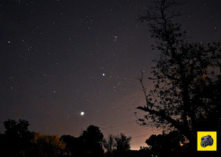
A bright meteor slices through stars of the constellation Pisces from right-to-left around 4:38 AM, Tuesday, July 31, 2012. The meteor was part of the Southern Delta Aquarids meteor shower which peaked the night before and was bright enough to overcome city light pollution (brightness at right) to the south. This image looks SSE from Bowman Woods Park in Cedar Rapids, Iowa. It was shot as a 13-second exposure at f/3.5, 400 ISO and 18mm focal length. This observation session produced about 4-5 meteors per hour.

Read more...

Dazzling East Sky

Monday, July 30, 2012


Planets, constellations and star clusters spangle the east sky as seen from the grounds at Echo Hill Presbyterian Church near Marion, Iowa around 4:34 AM, Monday, July 30, 2012. The -4.40 magnitude planet Venus stands out brightest at center with the -2.15 magnitude planet Jupiter above and right of it. The constellation Auriga is seen at upper left, Taurus just right of Jupiter and the star cluster Pleiades above the Jovian planet. Also peeking above the horizon below and right of Venus are the stars Betelgeuse (lower) and Bellatrix in the constellation Orion. Image is a 30-second exposure at f/3.5, 320 ISO and 18mm focal length. Clouds had just recently moved out toward the south (right) allowing this clear-sky shot.

Read more...

Boyson Park Trail Star Trails

Sunday, July 29, 2012


This camera position looking southeast, located on the Boyson Park Trail near Donnelly Park in Marion, Iowa, captured an individual 30-second exposure (bottom image) and a stacked combination of 104 exposures (top image) in the predawn hours of Saturday, July 28, 2012. The total exposure time for the top image was one hour (from 3:00-4:00 AM) and includes the streak of the communications satellite Iridium 6 (at center, just right of tower). Each exposure (including the single one at bottom) was shot at f/3.5, 320 ISO and 18mm focal length. The circled area above and right of the tower at bottom shows the dim 5.78 magnitude planet Uranus at 3:15 AM.

Read more...

Breathtaking Planets

Saturday, July 28, 2012


Like two early morning dark sky beacons, the rising planets Venus and Jupiter were so bright they almost took my breath away! This east-sky image was shot around 4:13 AM, Saturday, July 28, 2012, from near Donnelly Park in Marion, Iowa. Venus shone at -4.41 magnitude and Jupiter at -2.14 magnitude. Just right of Jupiter is the "head" of the constellation Taurus the bull. Above and just right of Jupiter is the star cluster Pleiades and at far left is the 0.06 magnitude star Capella in the constellation Auriga. Venus shows a bit of an aura here because of its low position in the Earth's atmosphere which at this moment contained 96% humidity. The image is a three second exposure at f/3.8, 3200 ISO and 20mm focal length.

Read more...

Not THAT Much Of A Cool Down!

Friday, July 27, 2012


After a day's high temperature of 104 degrees F on Wednesday, July 25, 2012, these images show gust front storm clouds approaching from the west, promising a welcomed cool down. Although current air temperatures were still around 87 degrees at this time, the continuous strains of Christmas music was heard blaring into the night from the nearby neighborhood Bowman Woods Swim & Racquet Club on Boyson Road at Brentwood Drive NE in Cedar Rapids, Iowa--presumably a "Christmas-In-July" novelty statement because of the sweltering weather. These images look west across Bowman Woods Park toward Bowman Woods Elementary School. The top image, shot at 9:36 PM, shows backlit clouds from lightning. The bottom image, shot at 9:51 PM,  shows a weak and ragged shelf cloud forming on the leading edge of the gust front. The top image is a 7-second exposure at f/5.6, 320 ISO and 18mm focal length; bottom image is an 8-second exposure at f/6.3, 320 ISO and 18mm focal length.

Read more...

Long Distance Illinois Storm

Thursday, July 26, 2012


About 110 miles separated the storm from the observer as seen from the top image around 4:21 PM, Thursday, July 26, 2012. The camera was at Bowman Meadows, the new housing development under construction south of Boyson Road and west of Alburnett Road in Marion, Iowa and the storm was in Lee County, Illinois--east of the town of Sterling. The bottom image is a Quad Cities National Weather Service 4:08 PM radar capture of the severe-warned storm.

Read more...

That's A Hot One!

Wednesday, July 25, 2012


With temperatures hovering around 104 degrees F, the landscape was sweltering under nearly-cloudless skies just north of Echo Hill Presbyterian Church near Marion, Iowa Wednesday afternoon, July 25, 2012. The official high temperature for the day actually fell short of the all-time Cedar Rapids record by two degrees. The top image was shot at 4:30 PM, the bottom at 4:32 PM. An approaching line of thunderstorms from the west later in the evening provided hope for some much needed rain and cooler temperatures for the area.

Read more...

Eeny, Meeny, Miney, Moon

Tuesday, July 24, 2012


A choice of celestial object observation was apparent in the southwest sky around 9:13 PM, Tuesday, July 24, 2012 as seen from just west of Christ Community United Methodist Church in Marion, Iowa. This evening's event featured a cluster of two planets, the Moon and a bright star. The Moon (center) was a waxing crescent. Above and left of the Moon is the 0.96-magnitude star Spica in the constellation Virgo. Above Spica is the 0.77-magnitude planet Saturn and above and right of the Moon is the 1.03-magnitude planet Mars. This image is a 1.3-second exposure at f/14, 1000 ISO and 26mm focal length.

Read more...

Cumulus Parade

Monday, July 23, 2012


Contrasts in the heavens and earth are evident here as cumulus clouds dot the sky over an unsown farm field in this view looking northeast from the Boyson Trail about .2-mile south of Boyson Road in Marion, Iowa around 3:02 PM on Sunday, May 2, 2010. This field would be the future site of Bowman Meadows, a new housing development, with construction beginning in 2012.

Read more...

Rollin' In

Sunday, July 22, 2012


This "mini" storm chase from my home in Cedar Rapids to the Center Point, Iowa exit--a distance of about 11 miles--produced these video frame capture images of a roll cloud approaching from the the northwest as seen northbound on Interstate 380 around 5:37 PM on Friday, June 18, 2010. The top image was located about .2-mile NW of Hagerman Road and about 2 miles south of Toddville, the bottom image was located about .5-mile south of Quail Ridge Road (bridge overpass in the background) and about 3.5 miles south of the Center Point exit (Exit 35). The bright area under the cloud and behind the trees in the bottom image is the flash of lightning. The somewhat rare roll cloud is formed when a thunderstorm's cool outflow races out ahead of the main storm causing warm air to rise only to tumble back down on the backside of the outflow, causing the air to spin horizontally well out ahead of the approaching storm.

Read more...

New Weather Station

Saturday, July 21, 2012

This Davis Instruments Vantage Vue 
rooftop weather station replaces the 
former Oregon Scientific WMR968 
station that was damaged by a falling
tree limb during a strong straight-line
storm on June 29. This wireless station 
was installed Saturday morning, 
July 21, 2012. All of the various data 
components are encapsulated in one 
Integrated Sensor Suite (ISS) shell. The
arm of the previous station that held the 
wind vane and anemometer was broken
off, but temperature, dew point, humidity, 
barometric pressure and time & date 
continue to function.

Read more...

Fifi Flyover

Friday, July 20, 2012


"I would make a terrible combat photographer" my dad would like to say to me as "Fifi," this Commemorative Air Force (CAF) B-29 Super Fortress bomber--the only airworthy one of its kind in the world--made two quick passes near my home in Cedar Rapids, Iowa on Friday evening, July 20, 2012. Hearing the droning engines, I raced outside with my camera, and in my fumbling haste and excitement failed to focus or even zoom properly on the aircraft as it made its fleeting appearance aloft. The inset shows "Fifi" at 5:15 PM on it first pass, heading east; and the main image at 5:17 PM as it was flying south. The flights were part of a two-day stay at the Eastern Iowa Airport by the aircraft. The B-29 served the United States Army Air Corps during World War II from 1943-1945, and then again during the first stages of the Korean War in 1950 in an emergency capacity, even though by then it was vulnerable to defensive attack.

Read more...

Archer Drive Sunset

Thursday, July 19, 2012


The sun drops toward the western horizon as seen from Archer Drive in the new Bowman Meadows housing development in Marion, Iowa around 8:29 PM, Wednesday, July 18, 2012. Sunset was at 8:38 PM. Cirrostratus clouds enhance the sky color.

Read more...

Catching Some Rays

Wednesday, July 18, 2012


This cumulus tower, spiking around 50,000 feet, was still reflecting sunlight some 12 minutes after sunset as seen in the east sky around 8:50 PM, Wednesday, July 18, 2012. Camera location was at Archer Drive in the new Bowman Meadows housing development in Marion, Iowa, with the tower located about 50 miles away, close to the town of Delmar near the border of Jackson and Clinton counties. The billowing cloud proved to be a teaser however, refusing to drop much needed rain here. Where rain did fall was in the extreme northeast part of the state--nearly an inch in some places. My home thermometer showed a peak temperature of 100.2 degrees F at 2:48 PM on this day. Iowa City recorded an official temp of 104 degrees! The bottom image shows the Quad Cities National Weather Service radar at 8:50 PM CDT.

Read more...

Reflections Of A Celestial Event

Tuesday, July 17, 2012


Bright enough to stand out in the sky above the highly-illuminated Quaker Oats cereal mill in Cedar Rapids, Iowa--the trio of Jupiter, the Moon and Venus were a visual treat at almost any location you could choose during the early morning hours of Sunday, July 15, 2012. The still waters of the Cedar River reflected not only the light of Quaker Oats but also the Moon (top image). In the bottom image, taken near a railroad bridge that survived the 2008 flood, the planet Venus can be seen just above and touching the grain elevator at left, with the Moon and Jupiter above it. Venus shone at magnitude -4.47; Jupiter, -2.09. The top image, shot at 3:47 AM, is a three-second exposure at f/11, ISO 1000 and 32mm focal length. The bottom image was shot at 3:58 AM and is a six-second exposure at f/16, ISO 400 and 18mm focal length.

Read more...

Arctic Phenomenon Takes Summer Vacation

Monday, July 16, 2012


The Aurora Borealis, the dancing, shimmering, ghostly light show far up in Earth's atmosphere caused by the collision of energetic charged particles from the solar wind, is usual for arctic regions and dark winter months across the northern United States. It is not usual for it to occur in the mid-latitudes of the USA in July. Our sun is nearing its 11-year cycle solar maximum, which at times allows rare glimpses of The Northern Lights farther south. In addition to Iowa, other states reporting recent activity were: Washington, Oregon, California, Colorado, Utah, Kansas, Nebraska, South Dakota, Missouri, Wisconsin, Minnesota, Illinois, Arkansas and Michigan. The three images above were shot from just north of Echo Hill Presbyterian Church near Marion, Iowa. Tops of the streamers reached as high as 36 degrees above the horizon. A geomagnetic storm arrived around 9:00 AM CDT on July 14 but did not appear at this location until the predawn hours of July 15. These images were taken from 4:28-4:33AM, were exposed from 6-20 seconds using an ISO of 1000-1250 at f/4.5. The ever-increasing light of dawn finally washed out and ended the show.

Read more...

Little Bit Of Night Sky For Everyone

Sunday, July 15, 2012


I probably got a total of about three hours of sleep on the night/morning of July14-15, 2012, viewing a very busy celestial show that included meteor streaks, planets and the moon in conjunction and an Auroral display. Unfortunately the bright meteor streak image I was lucky enough to capture turned out mushy--due to a gathering ground fog. That photo was shot around 11:00 PM, July 14 during which time I was on alert at a position just north of Echo Hill Presbyterian Church near Marion, Iowa for the expected arrival of the Northern Lights. I gave up that vigil around 11:30, went home to get a little sleep, then got up again and drove to downtown Cedar Rapids, to compose a shot of the Moon, Venus and Jupiter in the east sky overlooking the Cedar River and the Quaker Oats cereal plant from 1st Street NW (top image). Upon returning from that location I decided at the last minute to check out the Echo Hill location one more time. Great decision--the Aurora Borealis were very active (bottom image), with streamer tops reaching as much as 36 degrees above the northern horizon. Temperatures were 68 degrees F with 94% humidity and minimal interference from insects. The auroral display continued until it became washed out by the approaching glow of sunrise. The constellation Ursa Major (Big Dipper) can be seen at left. Top photo was shot at 3:47 AM, and was a three second exposure at f/16, ISO 1000 and 22mm focal length; bottom photo was shot at 4:32 AM, and was an eight second exposure at f/4.5, 1250 ISO and 18mm focal length.

Read more...

Illuminated Backdrop In New Housing Development

Saturday, July 14, 2012


A bank of cumulus clouds are highly reflective of the setting sun as seen in the background of one of the entrances to the new Bowman Meadows housing development in Marion, Iowa around 8:27 PM on Wednesday, June 13, 2012. At left is Boyson Road. This image looks east.


Read more...

Cherry Location

Thursday, July 12, 2012


Iowa State University meteorology students and storm chasers wait along Cherry Avenue, a gravel road just a tenth-of-a-mile south of Highway 175 (seen in the background) and about 2.8 miles west of Onawa, Iowa exit of Interstate 29 around 5:56 PM, Saturday, April 9, 2011. Severe weather was approaching from the left in this image. About ten minutes after this photograph was taken, the chase resumed--driving north, then east, following the SE flank of a strong storm system that would drop a small (EF0) tornado northeast of Onawa within a half hour then a much stronger (EF3) twister at Mapleton a little over an hour later. The chasers are from left: Bryce Link, Sam Schreier (leaning on car), Tyler Roney (foreground), Ryan Alliss, Nick Carletta and Tristan Morath (behind Carletta).

Read more...

Mare's Tails At Dusk

Wednesday, July 11, 2012


Mare's Tail (cirrus incinus) clouds streak the horizon around 9:30 PM, Sunday, July 8, 2012 looking WNW from just west of Christ Community United Methodist Church in Marion, Iowa. Sunset was about 45 minutes earlier. The street visible at lower right is Forest Lane, just south of East Robins Road in Marion, and just east of the Marion/Cedar Rapids city border. This image is a 1.5-second exposure at f/13, 640 ISO and 200mm focal length.

Read more...

Pre-Dawn Performance

Tuesday, July 10, 2012


The planets Venus and Jupiter were back within a few degrees of one another in the east sky during the early morning hours of Tuesday, July 10, 2012. Venus shone at a stunning -4.47 magnitude, while Jupiter also delighted at -2.07 magnitude. Also in the mix was the 0.84 magnitude star Aldebaran (in the constellation Taurus and seen just below and right of Venus), and the 1.62 magnitude star Elnath (also in Taurus and seen above the tree line in the bottom image at left). Aldebaran is 65 light years from Earth, Elnath 131 light years. The Pleiades star cluster is visible above Jupiter in the lower image. The images were captured from Archer Drive in the new housing development of Bowman Meadows, just south of Boyson Road in Marion, Iowa. The top image, shot at 4:54 AM, is a 3 1/2-second exposure at f/11, 640 ISO and 40mm focal length. The bottom image, shot at 4:43 AM, is a 5-second exposure at f/13, 1000 ISO and 26mm focal length. Clouds just above the horizon were slowly drifting from right-to-left.

Read more...

Hard To Identify, Even Harder To Pronounce

Monday, July 9, 2012


The conditions that kept me from photographing the planet Mercury in the west sky at twilight on Sunday, July 8, 2012, actually created this optical phenomena in which I believe is known as a Crepuscular Ray. I had observed a long arching blue shaft (top image) in the northwest sky that I originally thought might be some kind of a precursor to an impending Aurora Borealis display or something of that nature.  Crepuscular (meaning twilight) Rays, also known as God Rays, are rays of sunlight that appear to radiate from a single point in the sky. These rays, which stream through gaps in clouds (which in this case obscured Mercury) or between other objects, are columns of sunlit air separated by darker cloud-shadowed regions. The rays are so pronounced because of the contrasts of light and dark at this hour. This images were photographed at 9:10 and 9:18 PM, and look over East Robins Road from just west of Christ Community United Methodist Church in Marion, Iowa.

Read more...

Embossed Sky

Saturday, July 7, 2012


A very textured-looking north sky is shown looking over 74th Street NE from C Avenue in Cedar Rapids, Iowa around 9:25 AM, Sunday, July 1, 2012. The cloud formation is known as altocumulus undulatus (mackerel sky). The patterns in the formation resemble the scales on a mackerel fish, thus, the name. Altocumulus is an indicator of moisture and instability at mid levels of altitude (8,000-20,000 feet). If the lower atmosphere is stable and no moist air moves in, the weather will most likely remain dry, which in fact occurred here. This patch of altocumulus moved off within 20 minutes or so of the photograph, leaving a brilliantly clear blue sky in its place.  

Read more...

Bloomin' Hot!

Friday, July 6, 2012


This small field of wildflowers that included Yellow and Narrow Leaf Coneflowers and Wild Bergamot seemed oblivious to the wilting 100-degree F heat near Echo Hill Presbyterian Church north of Marion, Iowa around 4:33 PM, Friday, July 6, 2012. The century mark was reached here for the first time this year. These types of prairie wildflowers actually survive extreme heat, drought and poor soil and thrive in full sun. This image looks north. The "official" high for the day as recorded at the Cedar Rapids airport was 99 degrees. The "official" reading of 100 degrees F for Cedar Rapids the following day was the first since July 13, 2005 and it tied a record for the day of July 7.

Read more...

Steamy Acres

Thursday, July 5, 2012


This farm acreage simmers in 98-degree F heat around 5:26 PM, Thursday, July 5, 2012.  Image looks west and was located on the C Avenue Extension about .2-mile north of County Home Road and about 1.5 miles north of Robins, Iowa. Some areas of Iowa reached the century mark on this day. Cedar Rapids has already experienced at least 12 90-degree days in 2012.

Read more...

Dawn Duo

Wednesday, July 4, 2012


Last seen together in February and March, the planets Venus and Jupiter are in close proximity once again, rising in the east just before dawn. This view looks over a cornfield about .1-mile east of Echo Hill Presbyterian Church in Marion, Iowa. Venus, the lower and brightest object, shines at magnitude -4.46; Jupiter (above Venus), -2.05. Also visible is the 0.84-magnitude star Aldebaran in the constellation Taurus (below Venus); the Pleiades star cluster (above Jupiter); a portion of the stars of Perseus (above left of the Pleiades); the star Capella in Auriga (far left). This seven second exposure, shot around 4:38 AM, July 4, 2012, was imaged at f/7.1, 800 ISO and 18mm focal length. Sunrise was at 5:36 AM. The air temperature at this time was a balmy 75 degrees with 82% humidity. Strangely, no small "critters" or insects interfered with my photo session.


Read more...

Oh, The Irony Of It All...

Tuesday, July 3, 2012


Okay, I had been complaining about the "quiet" 2012 severe storm season for Cedar Rapids, Iowa for months. Several conditions had conspired to inhibit storm formation in the eastern part of the state. Storms either moved north or south as they progressed eastward or fizzled out. Things were looking different--and much more promising--on the evening of June 29, 2012. A large storm cell that had earlier overturned semi trucks on Interstate 80 near Newton was staying strong and moving right toward Cedar Rapids. This was a straight-line wind gust front, one typical of summer. The top two images above show the ominous shelf cloud at the leading edge of the gust front as seen from my spotting position at Noelridge Christian Church on C Avenue NE around 5:33 PM. Despite winds around 60 mph here and for many blocks around, I could see no significant damage anywhere. But upon my return home a little over a mile away, our house was the only one to have a good-sized limb fall on it--this one even smashing my roof-mounted weather station! The bottom images show the limb on the roof the next morning and me clearing the lighter stuff. I would have to hire a professional business to remove the rest. The limb was weaken by "dry rot."

Read more...

Gust Front Sequences

Monday, July 2, 2012


The gust front cometh! The top image shows a sequence of four photo panels with a rapidly materializing shelf cloud low on the horizon and closing fast as seen in the southwest sky at Noelridge Christian Church in Cedar Rapids, Iowa on the evening of Friday, June 29, 2012. The shelf cloud was riding the leading edge of the gust front. In the background is part of the Colton Square Condominiums. Each panel is one minute apart from the other. Top left: 5:28 PM, top right: 5:29 PM, bottom left: 5:30 PM and bottom right: 5:31 PM. The bottom group of images shows Des Moines radar returns of the storm system from 3:30 PM-6:00 PM. Cedar Rapids is indicated with a white circle. Winds as high as 80 mph were produced in some areas from the gust front, with reports of semi trucks being blown over on Interstate 80 near Newton.

Read more...

Relentless Approach

Sunday, July 1, 2012


The shelf cloud in the top two images was moving swiftly and relentlessly toward my camera's position at Noelridge Christian Church on C Avenue NE near Boyson Road in Cedar Rapids, Iowa around 5:33 PM, Friday, June 29, 2012. The ragged-looking shelf cloud was the leading edge of a very windy gust front that was spreading out in a bow shape. The radar "bow echo" can be seen in the bottom image as a thin dark red color, indicated by the arrow. Gust front winds in certain areas of Eastern Iowa reached speeds of from 50-80 mph. Also known as "arcus" clouds, shelf clouds are products of cool, sinking air from a storm cloud's downdraft that spread out across the land's surface on the leading edge of the gust front. This cool outflow cuts under the warm air being drawn into the storm's updraft, lifting the warm air and making it condense. A sharp, strong gust front will cause the lowest part of the leading edge of the shelf cloud to become ragged and lined with rising fractus (scud) clouds (see top image). Striations in the shelf cloud (as seen in the middle image) are caused by cool and warm air acting upon each other creating convergence (lifting). The top two images look southwest.

Read more...

  © Blogger template On The Road by Ourblogtemplates.com 2009

Back to TOP