Bands On The Run

Tuesday, March 21, 2017


Fast moving stratus clouds with gaps between layers produced colorful and striking displays at sunset on Sunday evening, March 19, 2017. These three images, all captured around 7:00 pm CDT, look west over Bowman Woods Park in Cedar Rapids, Iowa. Air temperature was 55 degrees F. Nikon D7200 DSLR camera.


Read more...

Stel-laaaaaaaaaaaa!!!

Monday, March 13, 2017


No, it's not about A Streetcar Named Desire. It was the arrival of Winter Storm Stella in the midwest. Anticipation of the storm was welcomed by some but viewed with contempt by others--including me--ruining the springlike trend we had been experiencing. Above, a sun halo, created by ice crystals, hangs in a nearly clear sky like a harbinger of the wintry weather at 2:10 pm CDT, Sunday, March 12, 2017 in Cedar Rapids, Iowa. A little over three hours later the first small flakes began to waft through the air as Stella announced her presence.


Fast forward to 5:48 am the next day (above) as most of the snow from the storm had fallen and had created a white landscape. In the background is Bowman Woods Park. Cedar Rapids received an official 5.7 inches of snow. Stella continued east, sure to wreak havoc in the northeast part of the country. Nikon D7200 DSLR camera.

Read more...

Interstate Interchange Storm

Sunday, March 12, 2017


Actually returning home from a previous storm spotting trip, this storm flared up as I was westbound on Interstate 80 near Iowa City on Tuesday, February 28, 2017. The above image, a Go Pro Hero 4 video frame capture taken around 5:10 pm CST, shows lightning discharge from a cloud seen about one mile east of the Interstate 380 interchange.


A minute later and a mile closer, the cloud grows larger in this Go Pro image at the I-380 exit. The storm cell was located about 10 miles distant, near Oxford, Iowa.


Northbound on I-380 at the North Liberty exit around 5:20 pm. Heavy rain in heavy traffic which included (estimated) penny size hail. 


Radar screen capture of image directly above it. Red area shows more intense part of the storm, and the target icon my position.

Read more...

Second Round Was A Knockout

Wednesday, March 8, 2017


A second early season severe weather event in Iowa, just one week removed from the first, occurred on Monday, March 6, 2017. An SPC Enhanced Risk was posted for much of the state at 7:00 that morning. By 1:30 pm CST, storms began firing up about 50 miles west of Omaha, Nebraska, and 25 minutes later Tornado Watch 61 (above) was issued, including most of Iowa.


The storms organized into an impressive and intense unbroken line, well beyond the north and south borders of Iowa. The top panel in the image above shows a WeatherTap radar screen capture at 3:45 pm, and the bottom a RadarScope image for 4:15 pm. The line of storms were moving ENE and at a swift pace--around 53 kts at times.


Meanwhile, in Cedar Rapids at 3:55 pm, favorable storm conditions prevailed, as seen above in my Davis Vantage Vue weather station screen.


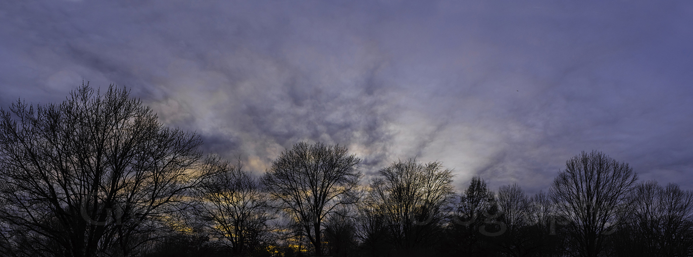
This view of the west-northwest sky from Noelridge Christian Church in Cedar Rapids at 6:20 pm shows the approach of the leading edge of the line of storms, the most intense area now located about 100 miles distant, near the Interstate 35/US Highway 20 interchange in central Iowa. iPhone 6 Plus camera image.


It is now 8:30 pm and I am set up for spotting on Oliver Court, just south of Boyson Road and just west of Alburnett Road in Marion, Iowa. The sky (above, looking west) is supercharged with
lightning. The most intense area of the storm line was at this moment 34 miles to the WSW, near Belle Plaine, Iowa, and approaching fast! This image was an 8 second exposure at f/6.3, 250 ISO and 22mm focal length. Nikon D7200 DSLR camera images.


8:45 pm and the lightning is becoming more intense, with thunder rumbles over my head. In the background is the Bowman Meadows housing development.


8:47 pm. The heavy line of storms was now 19 miles to the WSW, near Newhall, Iowa. The wind had picked up considerably. Gusts cause me to hold on to the camera tripod to keep it steady during exposures and I almost lose my hat several times! (Gusts were probably around 50 mph). The above lightning photo is a 2-image stack. Sirens were now sounding and I was trying to keep a low (lightning) profile by crouching low (not recommended).


My iPhone RadarScope image capture at 8:53 pm. Sirens were wailing. The blue circle shows my spotter position on Oliver Court.


Suspicious lowering in a tornado-warned area approaching from the southwest and about 14 miles distant, near Walford, Iowa. The time corresponds to the radar image above. Minutes after this image was captured I finally took refuge inside my car. Outflow-blown drenching rain crawled along the ground like a mini front in my direction, and my car was soon engulfed, along with (estimated) 50-60 mph winds and nickel size hail. Some 10 tornadoes were reported in the state on this day.


Read more...

Getting An Early Start On The Season

Wednesday, March 1, 2017


Around midday on Tuesday, February 28, 2017, the SPC issued a Moderate Risk area, centered in north-central Illinois. By early afternoon the likelihood of a tornado watch for this area--which now included SE Iowa was discussed. Tornado Watch 42 was then issued at 3:00 pm, valid until 10:00 pm, which included parts of Missouri, Iowa, Illinois and Indiana. On February 28!


Although I got home from work about 3:15 pm, I procrastinated enough from watching the strength and track of a severe cell west of Iowa City, that I didn't get started on this chase until 3:30.


With the inevitable traffic issues, I was briefly held up before Interstate 380 from Boyson Road. The above image looks southwest from Boyson Road at Robins Road in Hiawatha, Iowa at 3:35 pm. The most intense part of the storm was located about 35 miles distant, about 5 miles NW of the town of Wellman. My intention at this moment was to travel down I-380 and catch the cell before it moved across it and too far east. It soon became obvious I was too late to accomplish this.


The new plan was to drive east and try to head it off, as its track was in a northeasterly direction. The quick change of plans took me east on US Highway 30. This image shows rain bands to the north at 4:15 pm as I was about 2.5 miles west of Stanwood, Iowa. My new plan would take me south on Highway 38, the turn being just east of Stanwood.


A field near Cummins Manufacturing in Tipton, Iowa provided this perspective of the severe cell--now tornadic--at 4:40 pm. The white-topped cloud in the background was located about 67 miles to the east, just NW of Sterling, Illinois. The turbulent area at right was 11 miles away, just north of Durant, Iowa. Temperature was 57 degrees F, dew point 54 degrees and relative humidity 88%. Nearby rivers contained banks of fog on their surfaces.


This radar image corresponds to the photograph above it, and includes my position (lower left) and the areas of intensity.


4:45 pm. On the road again southbound on Highway 38 just south of Tipton and looking east. This was a fast moving cell, and it had long since left me in its wake. I decided to connect with Interstate 80, then to I-380, and return home. But it was not over!


As I approached Iowa City from the east, a new storm appeared. The above image, looking west and located on I-380 just north of the I-80 interchange at 5:15 pm, shows a small but intense area sporting a layered lowering. In the background is Marengo Road.  At the North Liberty exit minutes later, this storm began to drop penny size hail. The large storm system on this day spawned over 20 tornadoes in several states. Nikon D7200 DSLR camera.

Read more...

  © Blogger template On The Road by Ourblogtemplates.com 2009

Back to TOP