Just Around The Corner, There's A Rainbow In The Sky

Thursday, June 30, 2016


A massive rainbow, spanning much of the south, west and north skies is seen here in a panorama looking west along Progress Drive at Martha's Way in Hiawatha, Iowa on Thursday morning, June 30, 2016. Time was 6:14 am CDT. The towering rainbow persisted some 15 minutes or more and at times showed a double of itself. iPhone 6 Plus camera.

Read more...

Luminescent Layers

Wednesday, June 29, 2016


Illuminated by the setting sun, these stratocumulus undulatus formations graced the western sky on the evening of Wednesday, June 29, 2016 from Bowman Woods Park in Cedar Rapids, Iowa. The clouds appeared over the park just prior to an outdoor concert performance by the Cedar Rapids Municipal Band, playing in the city for the 66th straight year. The images captured above spanned a time frame from 7:12-7:17 pm CDT. Nikon D7200 DSLR camera.

Read more...

Trackin' The Storm In 2009

Tuesday, June 28, 2016


Loaded railroad tracks and bridge provided the foreground element for this severe weather storm image at Coralville Lake in Johnson County, Iowa on Father's Day, June 21, 2009. Time was 8:05 pm CDT. Along for the "mini chase" from Cedar Rapids was son Ryan. The image looks west along Interstate 380 toward the tornado-warned storm cell which is located about 16 miles distant, just west of the Amanas. Kodak Z812 IS digital camera.

Read more...

Orange Field

Monday, June 27, 2016


This small-in-area but great-in-intensity orange-colored sunset is viewed from rural Shueyville, Iowa on Saturday evening, June 25, 2016. The camera looks out over a soybean field in both images above at 8:32 pm CDT. Actual sunset time was 8:46 pm. Nikon D7200 DSLR camera.

Read more...

Pond Reflections

Sunday, June 26, 2016


A brilliant evening sky in rural Shueyville, Iowa reflected spectacularly on the surface of a local pond on Saturday, June 25, 2016. All images face west. Capture times for the three images were: top, 8:12 pm CDT; middle, 8:17 pm; bottom, 8:21 pm. Nikon D7200 DSLR camera.

Read more...

Beautiful Finish To Long Chase Day

Saturday, June 25, 2016


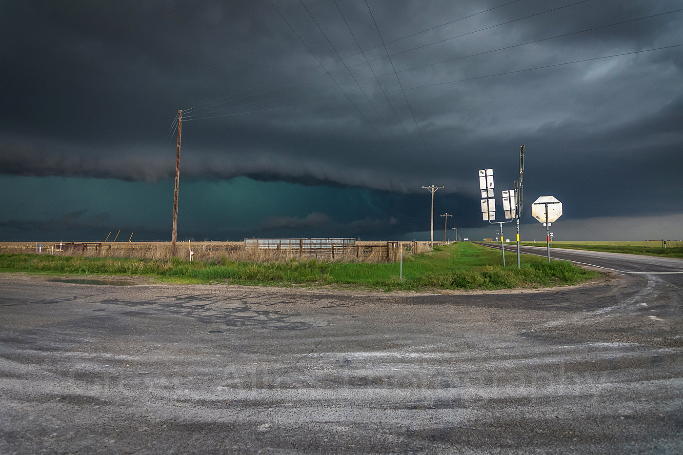
A somewhat iffy start to the day for severe weather and tornado chasing potential finished spectacularly with this view of the HP supercell that had been chasing us all the way through the Texas panhandle on the evening of Monday, May 16, 2016. Camera position here was a safe distance of about 19 miles ESE of the most intense part of the storm, at a cell phone tower lot along US Highway 83 in Hemphill County, and about 11.5 miles northwest of the town of Canadian. Time for all three images posted today was 8:18 pm CDT. The supercell's shelf cloud can be seen low along the horizon in the distant background.


A vertical view of the scene. The setting sun created brilliant color and shade contrasts.


Panorama image. At right watching the scene is Alan Broerse of News 9 Oklahoma City outside his Storm Tracker 9 vehicle, and Ryan Alliss in the foreground. The storm's heavy rain finally caught up with us as we entered the town of Canadian and continued unabated all the way to our night lodging destination of Woodward, Oklahoma. Nikon D7200 DSLR camera.


Radar screen capture of the moment with our position indicated with a target icon. Total travel distance from Cedar Rapids and back for this chase was 1,935 miles.

Read more...

Mixing Oil And Water

Friday, June 24, 2016


A small Texas panhandle prairie oil station is about to be overrun by an approaching HP supercell in the image above. Image looks west at 7:47 pm CDT, Monday, May 16, 2016, from the bend of Highway 281, about 13 miles southeast of the town of Spearman.


This panorama image spans the west sky (left) to the north at the same location and time. Note the intense rain and hail core lurking behind the supercell shelf cloud. Nikon D7200 DSLR camera.


A closely corresponding radar screen capture of the moment. The target icon shows our position in relation to the storm. The lavender color is the area of intense hail.

Read more...

Admiring From Afar

Thursday, June 23, 2016


This severe storm cell began firing up in Illinois just east of the Mississippi across the river from Camanche, Iowa around 6:20 pm CDT, Wednesday, June 22, 2016. The image above reveals its appearance at 6:51 pm, looking southeast from along C Avenue and just south of Echo Hill Road north of Marion, Iowa.


Another view from the same location but a minute later. A very strong overshooting top can now be seen peeking over the edge of the anvil at center.


6:54 pm and looking southeast from Echo Hill Presbyterian Church just a little south from the above two image locations. The area of the overshooting top, located about 100 miles distant near Sterling, Illinois, can be seen in the right circled area of the radar screen capture below. The billowing cumulus tower above right is the left circled area on the radar screen image. Over a half-dozen tornadoes were spawned from this system. Nikon D7200 DSLR camera.


Read more...

Almost Here...

Tuesday, June 21, 2016


One of many abandoned but still photogenic farm houses in the Texas panhandle, this one made for a great foreground element as the outflow from an HP supercell drew closer on the evening of Monday, May 16, 2016. Image looks northwest at 7:39 pm CDT from Highway 281 near Highway 1, about 9.3 miles southeast of the town of Spearman. As I approached this barbed-wire fence to get a better shot I was suddenly startled by a feral cat, which came flying out of the tall grass in the extreme foreground!


Above is a wider-angle view of the same place and time.


 7:40 pm. A still-wider (panorama) view, backpedaled more than a hundred feet to include all elements. Our chase vehicle can be seen parked along the highway at far left. Nikon D7200 DSLR camera.

Read more...

Ringer Of A Horseshoe

Monday, June 20, 2016


A horseshoe-shaped shelf cloud was becoming more defined in the now-increasing outflow-dominated HP supercell in the Texas panhandle at 7:33 pm CDT on Monday, May 16, 2016. The above image looks north from the junction of Highway 51 (foreground) and Highway 760, about 7 miles south of the town of Spearman. Storm was moving left-to-right in the picture.


West facing at 7:39 pm. Location is alongside Highway 281 at Highway 1, a little over 9 miles southeast of Spearman. The shelf cloud is low and menacing, packed with hail inside its core. Note the circling birds at upper left.


Panorama image at the same location and time. The abandoned farmstead in the foreground appears to be on the verge of being swallowed by the monster. 


Radar screen capture from this moment. White curve indicates area of the horseshoe. Target icon shows our position relative to the supercell, lavender color is hail, and the white arrows indicate storm movement.

Read more...

Now With An Outflow Horseshoe Base

Sunday, June 19, 2016


As the HP supercell matured in the Texas Panhandle on the evening of Monday, May 16, 2016, it began to form an outflow horseshoe base. The four images in today's posting were all stationary and located along Highway 520 at Highway 2, about 8 miles northwest of the town of Morse. The panorama image above was captured at 7:02 pm CDT and looks north.


A similar image one minute later.


7:03 pm and looking west along Highway 520. Ryan Alliss stands warily next to our vehicle as the storm draws nearer.


A slightly zoomed-in view of the rain and hail core looking north at the same time. Nikon D7200 DSLR camera.

Read more...

Keeping Pace On The Backroads Of The Texas Panhandle

Saturday, June 18, 2016


Now it was time to stay with, or try to get ahead of the advancing HP supercell in the Texas panhandle on the evening of Monday, May 16, 2016. Photo ops such as the image shown above made that difficult. It is 6:14 pm CDT and we are eastbound (right) on Highway 3212, pulled up at the intersection of Highway 807, about 16 miles east of Dalhart. The heavy rain and hail core (left, horizon) was to be stayed clear of!


A similar view, but later at 6:42 pm. We are on the move eastbound (right) on Highway CC at the intersection of Highway 17, about 5.8 miles northwest of the town of Sunray.


Three minutes later and still eastbound on Highway CC. We were just a short distance from a left turn (north) onto Highway 119, bringing us briefly but dangerously closer to the supercell, which sports an unusual inflow cloud in the image above. Nikon D7200 DSLR camera.


Radar screen capture corresponding closely to the times for images two and three. The target icon shows our position to the storm and hail core (lavender). The white arrows indicate storm movement.

Read more...

Pokin' The Bear

Friday, June 17, 2016


In the Dalhart, Texas area on Monday evening, May 16, 2016, this massive HP supercell was fast approaching. Our only major east option was US Highway 54, which in its northeasterly route would lead us right into the path of the storm. Above, the camera looks east as we are ready to turn left onto US Highway 54 (seen at far right in distance) at 6:01 pm CDT.


Now on US Highway 54 moments later and about 2 miles northeast of Dalhart. The supercell is about to cross our path at this point.


Closer yet at 6:05 pm. The decision had to be made quickly to get out of harm's way, so a short distance after this image was captured we turned east (right) on Highway 3212, then south on Highway 807. Note the opaque rain and hail core at far left of the image. Nikon D7200 DSLR camera.

Read more...

Makings Of An HP Supercell--Texas Style

Thursday, June 16, 2016


This was the scene at 5:58 pm CDT, Monday, May 16, 2016, one mile north of Dalhart, Texas. We are pulled off to the side of a newer road connecting US Highway 385 (seen in the background of the above image) and US Highway 54. The above image looks west toward one end of a High Precipitation (HP) supercell. The supercell features a roll cloud on its leading edge, seen at the lower right of the image.


Panning a little further right and now looking northwest, the roll cloud is seen more clearly.


Still further to the right and now looking northeast at the right edge of the massive supercell, which is taking on the classic "mothership" appearance.


Nearly the same view, but including Ryan Alliss capturing the spectacle with his cell phone camera. Our storm chase would quickly resume, heading down the highway toward the background. Nikon D7200 DSLR camera.

Read more...

In Hot Pursuit

Wednesday, June 15, 2016


Nervously glancing over my left shoulder, this is what was quickly following us after we got started southbound again on US Highway 385, just north of Dallam, Texas on Monday, May 16, 2016. Time was 5:43 pm CDT. The HP supercell was looking like something from War of the Worlds, blasting the ground as it went. In reality, the "blast" was RFD winds, heavy rain and hail. Note the inflow cloud feeding into it at right. Our next stop was the town of Dalhart. Nikon D7200 DSLR camera.

Read more...

Over The Rainbow

Tuesday, June 14, 2016


A very vivid, but low-to-the-ground rainbow is shown in the east sky from this camera position on Drexler Road at Sawyer Road (E16), about 2 miles east of Central City, Iowa on the evening of Tuesday, June 14, 2016. The top two images were captured at 5:12 pm, the bottom at 5:15 pm. In the bottom image, the storm cell is about to cover the rainbow as it is moving right-to-left (northeast). The evening featured a large number of isolated thunderstorm cells roaming throughout the state of Iowa--some being severe. Nikon D7200 DSLR camera.

Read more...

Watch Your Back!

Monday, June 13, 2016


Like a sinister stalker, the leading edge of this supercell was quickly following us as we made our way south on US Highway 385 in the Texas panhandle on the evening of Monday, May 16, 2016. This image and the three posted below look north alongside the road just north of the town of Dallam. The leading edge of the storm, which stretched from the west to the north sky, was chocked full of heavy rain and hail... and our intent was to get going before it caught us. Top image captured at 5:39 pm CDT.


Same time, but looking a little more toward the northeast. A former clearer sky is being eclipsed at right.


5:40 pm. Ryan Alliss stands close to the car as we were very near resuming our quick escape south toward the town of Dalhart. There was already a steady rain falling.


5:41 pm and ready to go! Nikon D7200 DSLR camera.


Radar screen capture of the moment (same as previous day's posting). Note our position with the short black arrow looking north, and the lavender hail core at the 1:00 position. White arrows indicate storm direction.


Read more...

  © Blogger template On The Road by Ourblogtemplates.com 2009

Back to TOP